to bellevue city council may 11 2014 bellevue wa from
play

TO: Bellevue City Council May 11, 2014 Bellevue WA FROM: - PDF document

TO: Bellevue City Council May 11, 2014 Bellevue WA FROM: Martin Nizlek, PhD. On behalf of WSSA RE: Ordinary High Water Mark (OHWM) Considerations in Draft SMP OHWM Basics Definition - The technical definition can be found on page 3-89 of


  1. TO: Bellevue City Council May 11, 2014 Bellevue WA FROM: Martin Nizlek, PhD. On behalf of WSSA RE: Ordinary High Water Mark (OHWM) Considerations in Draft SMP OHWM Basics Definition - The technical definition can be found on page 3-89 of the staff report - Essentially it's the line between water tolerant plants and upland, non-water tolerant plants 
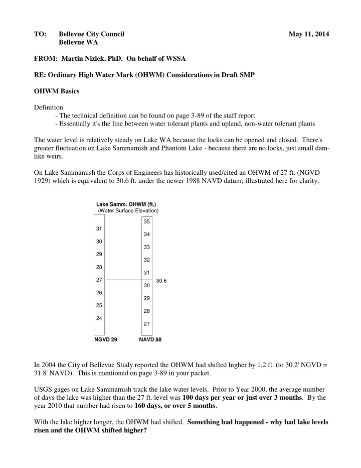
The water level is relatively steady on Lake WA because the locks can be opened and closed. There's greater fluctuation on Lake Sammamish and Phantom Lake - because there are no locks, just small dam- like weirs. On Lake Sammamish the Corps of Engineers has historically used/cited an OHWM of 27 ft. (NGVD 1929) which is equivalent to 30.6 ft. under the newer 1988 NAVD datum; illustrated here for clarity. Lake Samm. OHWM (ft.) (Water Surface Elevation) 35 31 34 30 33 29 32 28 31 27 30.6 30 26 29 25 28 24 27 NGVD 29 NAVD 88 In 2004 the City of Bellevue Study reported the OHWM had shifted higher by 1.2 ft. (to 30.2' NGVD = 31.8' NAVD). This is mentioned on page 3-89 in your packet. USGS gages on Lake Sammamish track the lake water levels. Prior to Year 2000, the average number of days the lake was higher than the 27 ft. level was 100 days per year or just over 3 months . By the year 2010 that number had risen to 160 days, or over 5 months . With the lake higher longer, the OHWM had shifted. Something had happened - why had lake levels risen and the OHWM shifted higher?

  2. CITIZENS IDENTIFY OHWM PROBLEM IS REDUCED OUTFLOW Basics of Weir and Outflow - Lake Sammamish The OHWM issue is intrinsically related to outflow. That outflow was significantly altered about 15 years ago. Following reconstruction of the weir (small dam) at Marymoor, the County requested to place a narrow strip of vegetation along each side of the center, low-flow channel. (Note: there are two outer channels that are critical, as they were intended to carry flow when the lake rises above the weir.) Cross Section of Sammamish River Below Weir at Marymoor Park The Corps allowed this vegetation placement as long as it was maintained annually. Documentation in the early 2000's shows the Corps warned King County that their maintenance was insufficient and recommended the public be forewarned (of possible consequences). And, in 2008, the Corps decertified the entire length of the river project as deficient because of alterations made along its length to Lake WA. It remains decertified today. Under the early 2000 letter of agreement, the County was to maintain the vegetation each year, but went to a 4 year cycle - cutting alternate sides every other year AND allowing the cuttings to remain in the outer channels. (About 2 years ago the depth of the resulting sediment had reached 3 ft. in places. This is reflected in the figure above.) A group of residents (primarily engineers and scientists) around the lake used County & USGS data in 2010 to show the causative relationship between lack of maintenance and degraded (reduced) outflow and higher lake levels. Several in the group agreed to a plan by the County to take corrective actions. (Marty Nizlek, Gil Pauley, and Dwight Martin of Sammamish were signers.)

  3. The County returned to annual maintenance, removed the cuttings and an illegal dam found in the channel ("transition zone" is the technical term) below the weir. They said they would evaluate possible benefits of removal of the sediment. Last summer King County removed half of the sediment (the half closest to the weir) in both outside channels. Because our visual experience suggests there's been an improvement, we have pushed for complete removal. The County recommends no further action (except routine maintenance) until a major improvement project is undertaken. It's called the Willowmoor Project. WILLOWMOOR PROJECT The project aims to replace the channels described earlier with a more natural area. It is in early planning stages, with concepts being developed by an advisory committee. While alternatives are developed, a series of technical analyses are underway; one of which has been completed. It's called the hydrology report, and looked at flows in and out of the lake, both historically and into the future. Several pertinent findings of the study include: > Flow into the lake is projected as stable for the foreseeable future. > The consultant does not foresee major, weather related changes causing increased in-flow. > Lake outflow has diminished in the period mentioned above (late 90's and beyond). > The report implicates poor vegetation maintenance in the channels as a key cause. > It also notes that reduced downstream river capacity (Redmond and beyond) is an issue. The last item in the list is significant. The Willowmoor project managers have declared that the project cannot result in downstream flooding AND the County may not be able to return outflows to the Corps' design level. The net result would be a project resulting in permanently higher water levels on the lake. CONCLUSION A series of issues beyond property owner control have shifted the OHWM on Lake Sammamish higher. The impact to property owners has been documented and shows damages to docks and loss of property. The Planning Commission recognized this and designated an "administrative" OHWM on Sammamish (and one on Phantom, as well). This line would be used to establish setbacks. Docks would continue to require a professional survey/study, and an applicant could also have their property's OHWM established independently by survey. WSSA seeks Council support to have the "administrative" water level recognized, so that setbacks are not moved landward on Lake Sammamish shoreline properties due to the artificially shifted water levels. In addition, WSSA urges Council support to assure that the County Willowmoor Project does not lead to a permanent shift of the OHWM on Sammamish.

Download Presentation
Download Policy: The content available on the website is offered to you 'AS IS' for your personal information and use only. It cannot be commercialized, licensed, or distributed on other websites without prior consent from the author. To download a presentation, simply click this link. If you encounter any difficulties during the download process, it's possible that the publisher has removed the file from their server.

Recommend


More recommend