
SLIDE 1
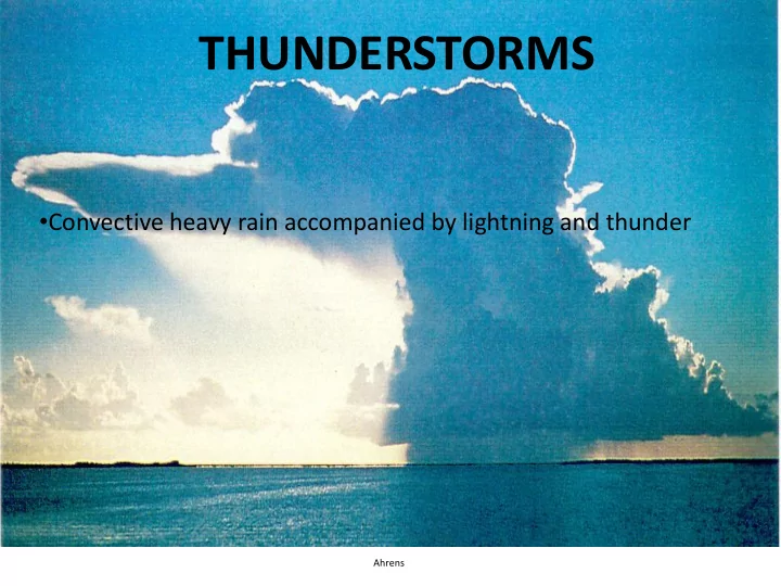
THUNDERSTORMS
- Convective heavy rain accompanied by lightning and thunder
Ahrens
THUNDERSTORMS Convective heavy rain accompanied by lightning and - - PowerPoint PPT Presentation
THUNDERSTORMS Convective heavy rain accompanied by lightning and thunder Ahrens Thunderstorms About 1,800 T-storms occur around the world at any instant Where do they occur the most? National Lightning Safety Institute Satellite lightning
Ahrens
About 1,800 T-storms occur around the world at any instant Where do they occur the most?
National Lightning Safety Institute
Satellite lightning frequency: flashes per km2 per year
National Lightning Safety Institute
Where do Thunderstorms occur the most often?
Supercell thunderstorms on a visible satellite image
CUMULUS STAGE
UPDRAFTS An “Air Mass” Thunderstorm, caused by heated surface parcels
MATURE STAGE
DISSIPATING STAGE (DOWNDRAFTS)
Microbursts and aviation dangers
Development of the sea breeze and formation of convection
How can the front be “seen” by radar?
Charge separation:
surfaces
charges get transferred
positive charge and then get carried toward the cloud top
but it can be much more complex
1: Stepped Leader A series of steps about 50 meters (160 ft) in length and 1 microsecond (0.000001 seconds) in duration. Studies of individual strikes have as many as10,000 steps! 2: Upward streamer Induction causes positive charges to trace an upward path from high, sharp points until channels meet 3: Connection Ionized path allows easy-flow of charge downward from cloud to surface 4: Return stroke Positive charge from the ground flows back upward along the path. This is where most of the current is: 30000 Amps produces heat, glow, and thunder
Lightning and the rumbling thunder: an issue of path distance
Red Sprites discharging from the top of a thunderstorm
(a dime is 11/16" which the NWS accepts as 3/4")
NWS definition of a severe thunderstorm
THREE MAIN TYPES: 1) SQUALL LINE THUNDERSTORMS 2) MESOSCALE CONVECTIVE COMPLEX (MCC) 3) SUPERCELL THUNDERSTORMS All three types last much longer than
All three types need warm air and other factors in order to form.
SQUALL LINE ON RADAR
*Develop ahead of cold fronts *Multi-cell storms *Often produce wind damage (DOWNBURSTS)
North, Northwest winds Cold air Clearing skies South, Southwest winds Warm air Clearing skies behind warm front Until cumulus clouds and thunderstorms ahead of the cold front Cooler air Stratus clouds Snow, sleet, rain ahead of warm front
Nebraska MCC moving Southeast, July 1997 – 7 hour difference between satellite images CIMMS, WISC U *MCC must live more than 6 hrs *MCC high cloud cover must be larger than 18,000 square miles (size of CT, RI, MA) *MCC high cloud cover must be circular in shape
Minnesota MCC moving Southeast, June 1994 NCDC
1993 Mississippi River, Grafton IL Flooding, USGS – the “500-year” flood
*Vertical Wind Shear *Two Downdrafts
Chaseday.com
A rotating column of air
http://esminfo.prenhall.com/science/geoanimations/animations/Tornadoes.html
Development of Spin in a thunderstorm: Divergence and Wind Shear
Tornado Tracks: Width, length, and intensity vary widely
http://www.spc.noaa.gov/faq/tornado/ef-scale.html http://whyfiles.org/013tornado/3.html http://www.pbs.org/wgbh/nova/tornado/dam age.html
NSSL
Tornadoproject.com
Area most likely to find favorable conditions for tornados
NSSL
NWS
NWS Norman
NWS Norman
Doppler on Wheels: 301 mph record measured wind speed
NWS Norman
NWS Norman
SPC
BOM Australia