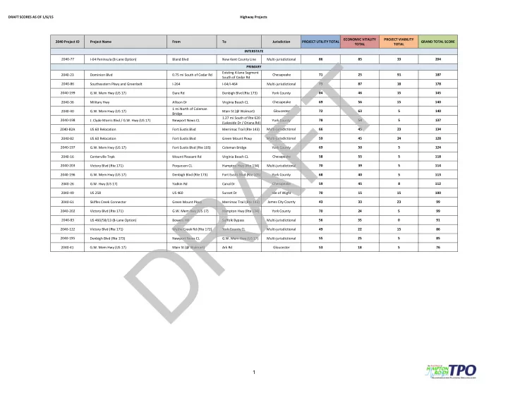

DRAFT SCORES AS OF 1/6/15 Highway Projects 2040 Project ID Project Name From To Jurisdiction PROJECT UTILITY TOTAL ECONOMIC VITALITY TOTAL PROJECT VIABILITY TOTAL GRAND TOTAL SCORE 2040-77 I-64 Peninsula (8-Lane Option) Bland Blvd New Kent County Line Multi-jurisdictional 86 85 33 204 2040-23 Dominion Blvd 0.75 mi South of Cedar Rd Existing 4-lane Segment South of Cedar Rd Chesapeake 71 25 91 187 2040-86 Southeastern Pkwy and Greenbelt I-264 I-64/I-464 Multi-jurisdictional 73 87 18 178 2040-199 G.W. Mem Hwy (US 17) Dare Rd Denbigh Blvd (Rte 173) York County 84 46 15 145 2040-36 Military Hwy Allison Dr Virginia Beach CL Chesapeake 69 56 15 140 2040-40 G.W. Mem Hwy (US 17) 1 mi North of Coleman Bridge Main St (@ Walmart) Gloucester 72 63 5 140 2040-198
- J. Clyde Morris Blvd / G.W. Hwy (US 17)
Newport News CL 1.27 mi South of Rte 620 (Lakeside Dr / Oriana Rd) York County 78 54 5 137 2040-82A US 60 Relocation Fort Eustis Blvd Merrimac Trail (Rte 143) Multi-jurisdictional 66 45 23 134 2040-82 US 60 Relocation Fort Eustis Blvd Green Mount Pkwy Multi-jurisdictional 59 45 24 128 2040-197 G.W. Mem Hwy (US 17) Fort Eustis Blvd (Rte 105) Coleman Bridge York County 69 50 5 124 2040-16 Centerville Tnpk Mount Pleasant Rd Virginia Beach CL Chesapeake 58 55 5 118 2040-203 Victory Blvd (Rte 171) Poquoson CL Hampton Hwy (Rte 134) Multi-jurisdictional 70 39 5 114 2040-196 G.W. Mem Hwy (US 17) Denbigh Blvd (Rte 173) Fort Eustis Blvd (Rte 105) York County 68 40 5 113 2040-26 G.W. Hwy (US 17) Yadkin Rd Canal Dr Chesapeake 59 45 8 112 2040-49 US 258 US 460 Sunset Dr Isle of Wight 70 15 15 100 2040-61 Skiffes Creek Connector Green Mount Pkwy Merrimac Trail (Rte 143) James City County 43 33 23 99 2040-202 Victory Blvd (Rte 171) G.W. Mem Hwy (US 17) Hampton Hwy (Rte 134) York County 70 24 5 99 2040-83 US 460/58/13 (8-Lane Option) Bowers Hill Suffolk Bypass Multi-jurisdictional 56 35 91 2040-122 Victory Blvd (Rte 171) Wythe Creek Rd (Rte 172) York County CL Multi-jurisdictional 49 22 15 86 2040-195 Denbigh Blvd (Rte 173) Newport News CL G.W. Mem Hwy (US 17) Multi-jurisdictional 55 25 5 85 2040-41 G.W. Mem Hwy (US 17) Main St (@ Walmart) Ark Rd Gloucester 53 18 5 76 INTERSTATE PRIMARY
1