RFAAP Site Status - URS Group December 2009 Current Site Status - - PowerPoint PPT Presentation

rfaap site status urs group december 2009
SMART_READER_LITE
LIVE PREVIEW

RFAAP Site Status - URS Group December 2009 Current Site Status - - PowerPoint PPT Presentation

RFAAP Site Status - URS Group December 2009 Current Site Status Final Action SSP RFI/CMS IM SSP RFI Action Workplan Fieldwork Workplan Fieldwork Workplan Description LTM MNA LUC NFA Location Report Report Complete SWMUs


slide-1
SLIDE 1

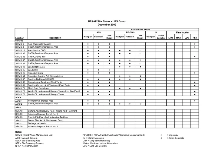
Location Description

Workplan Fieldwork SSP Report Workplan Fieldwork RFI Report Workplan Action Complete

LTM MNA LUC NFA SWMUs SWMU 6 Acid Wastewater Lagoon

  • SWMU 8

CaSO4 Treatment/Disposal Area

  • SWMU 13

Area Outside OBG

SWMU 35 CaSO4 Treatment/Disposal Area

SWMU 36 CaSO4 Drying Bed

  • SWMU 37

CaSO4 Treatment/Disposal Area

SWMU 38 CaSO4 Treatment/Disposal Area

SWMU 40 Landfill Nitro Area

  • SWMU 45

Landfill #3

SWMU 46 Propellant Burial

  • SWMU 54

Propellant Burning Ash Disposal Area

  • SWMU 57

Pond by Building 4931/4932

  • SWMU 68

Chromic Acid Treatment Plant Tanks

  • SWMU 69

Pond by Chromic Acid Treatment Plant Tanks

  • SWMU 71

Flash Burn Parts Area

  • SWMU 75

Waste Oil Underground Storage Tanks (Inert Gas Plant)

  • SWMU 76

Waste Oil Underground Storage Tanks

  • AOCs

AOC F Former Drum Storage Area

  • AOC Q

CaSO4 Treatment/Disposal Area

SSAs SSA 18 Sulfuric Acid Recovery Plant - Waste Acid Treatment

SSA 30 Asbestos Disposal Trench No. 1

SSA 60 Rubble Pile East of Administration Building

SSA 72 Oleam Plant Acidic Wastewater Sump

SSA 77 Garbage Incinerator

SSA 79 Asbestos Disposal Trench No. 2

Notes: SWMU = Solid Waste Management Unit RFI/CMS = RCRA Facility Investigation/Corrective Measures Study

= Underway AOC = Area of Concern IM = Interim Measures

  • = Action Complete

SSA = Site Screening Area LTM = Long-Term Monitoring SSP = Site Screening Process MNA = Monitored Natural Attenuation NFA = No Further Action LUC = Land Use Controls

RFAAP Site Status - URS Group December 2009

Final Action

RFI/CMS IM Current Site Status SSP

slide-2
SLIDE 2

N

SWMU 38/ AOC Q SWMU 13 SWMUs 40 and 71 SWMU 54 SWMU 37 SWMU 45 SWMU 35

Site Location Map

SWMU 57

slide-3
SLIDE 3

Radford Army Ammunition Plant

FACT SHEET SWMU 13

(December 2009)

Introduction This fact sheet describes the proposed RCRA Facility Investigation (RFI) investigation in the Solid Waste Management Unit (SWMU) 13 RFI study area located outside the current operational area of the open burning ground (OBG) at Radford Army Ammunition Plant (RFAAP). Background The SWMU 13 RFI study area is located in the western section of the Horseshoe Area (HSA) between the perimeter berm of the OBG and the north bank of the New River. The SWMU 13 RFI study area is the area adjacent to the OBG not addressed under the RCRA Subpart X Permit. Groundwater in the area of OBG is currently being evaluated under the facility’s Subpart X permit issued by the Virginia Department of Environmental Quality (VDEQ) in October 2005. Groundwater monitoring and any required corrective action for groundwater will be addressed under the facility’s Subpart X permit; therefore, groundwater will not be further investigated or addressed under this RFI. Soil sampling and any required corrective action within the OBG also will be addressed under the facility’s Subpart X permit; therefore, the soil located within the OBG will not be investigated as part of this RFI. The RFAAP RCRA Corrective Action Permit identified SWMU 13 as an area of concern that had the potential to pose a threat or potential threat to human health and the environment. SWMU 13 was a part of the Site Screening Process (SSP) investigation completed in 2007 which resulted in a recommendation of a focused RFI for the site. RCRA Facility Investigation (RFI) RFI field efforts were completed at the site in November 2008. The investigation focuses on soil conditions in this area and evaluates soil within the SWMU 13 RFI study area as a potential source for future impacts to the New River. A soil sampling grid was established within the SWMU 13 RFI study area to further assess the spatial distribution of lead in soil. Data was collected on a central aligned rectangular grid to provide coverage across the entire study area providing for approximately 79 sample point locations across the site, with two to three rows of samples between the OBG berm and the New River. Additional chemical data for semi-volatile organic compounds (SVOCs), explosives including nitroglycerin, and Target Analyte List metals were collected from 10 specific grid sample locations. These data was used to confirm SSP sample results and provide additional data for use in the risk assessments and background evaluations (for metals). Conclusions and Recommendations Lead was the primary chemical of concern identified in soil at the site. Based on the results of the risk assessments and fate and transport assessment, the RFI resulted in a recommendation of no further action for the study area. The data, findings, assessments, and recommendations are contained in the SWMU 13 RFI Report (Draft), July 2009, and is currently being reviewed by the USEPA and VDEQ.

slide-4
SLIDE 4
slide-5
SLIDE 5

Radford Army Ammunition Plant

FACT SHEET SWMUs 35, 37, 38, and AOC Q

(December 2009)

Introduction This fact sheet outlines the RCRA Facility Investigation (RFI) activities conducted at Solid Waste Management Units (SWMUs) 35, 37, and 38 – Calcium Sulfate Drying Beds and Area of Concern (AOC) Q – Calcium Sulfate Treatment and Disposal Area at Radford Army Ammunition Plant (RFAAP). RFI activities were completed in accordance with the United States Environmental Protection Agency (USEPA) RCRA Corrective Action Permit to the U.S. Department of the Army (Army) and Alliant Ammunition and Powder Company (Alliant) issued on October 31, 2000. Background SWMU 35 is an approximately 160 ft by 80 ft calcium sulfate drying bed located in the northeast section of the MMA at RFAAP between SWMU 8 (east) and SWMU 10 (west). The drying bed is an enclosed depressed area (approximately 5 ft from surrounding areas). A USEPA RCRA Facility Assessment (RFA) conducted at RFAAP identified the SWMU 35 calcium sulfate drying bed as having the potential to release contaminants into the environment. SWMU 37, SWMU 38, and AOC are calcium sulfate drying beds located along the New River in the northwestern section of the MMA. SWMU 37 is densely vegetated area comprising approximately 0.62 acres. It is located immediately southwest of, and adjacent to, the SWMU 9 Calcium Sulfate Settling Lagoons. SWMU 38 is a smaller densely vegetated area comprising approximately 0.23 acres. AOC Q is a densely wooded depression comprising approximately 0.076 acres. Each unit is surrounded by an earthen berm and has an approximate depth of 4 to 8 feet. Within the RCRA Corrective Action permit (Part II, Section D.4), there is a provision allowing for SWMUs or AOCs which are determined to represent negligible or minimal impact to be investigated in accordance with the EPA approved Site Screening Process (SSP). In 2007, a site screening process was performed at SWMU 37, SWMU 38, and AOC Q to assess whether releases of hazardous substances, pollutants, contaminants, hazardous wastes, or hazardous constituents have occurred to the environment at the sites. Based on the results of the site screening process, a focused RFI was recommended for the sites RCRA Facility Investigation (RFI)/Corrective Measures Study (CMS) RFI field efforts were conducted in 2007. At SWMU 35, 6 borings were completed inside and 4 borings were completed outside the drying bed to assess the nature and extent of contamination within the source area and the extent and volume of sludge inside the drying bed and two monitoring wells were installed at the site. Four monitoring wells (2 existing and 3 newly installed) were sampled as part of the RFI. At SWMU 37, 4 additional borings were completed inside and 3 additional borings were completed outside the drying bed to assess the nature and extent of contamination within the source area and the extent and volume of sludge inside the drying bed and two monitoring wells were installed at the site. During the SSP investigation, 3 soil borings had been completed inside the drying bed and 1 boring had been completed outside the drying bed. Three newly installed monitoring wells were sampled as part of the RFI. At SWMU 38/AOC Q, 5 additional borings were completed inside and 3 additional borings were completed outside the drying beds to assess the nature and extent of contamination within the source area and the extent and volume of sludge inside the drying bed and two monitoring wells were installed at the site. During the SSP investigation, 4 soil borings had been completed inside the drying beds and 2 borings had been completed outside the drying beds. Three newly installed monitoring wells were sampled as part of the RFI. Conclusions and Recommendations Metals and Aroclor 1254 were the primary chemicals of concern identified in soil at the sites. Based on the results of the risk assessments and fate and transport assessment, the RFI resulted in a recommendation of no further action for the study area. The data, findings, assessments, and recommendations are contained in the SWMUs 35, 37, 38, and AOC Q RFI Report (Draft), July 2009, and is currently being reviewed by the USEPA and VDEQ.

slide-6
SLIDE 6
slide-7
SLIDE 7