
SLIDE 1
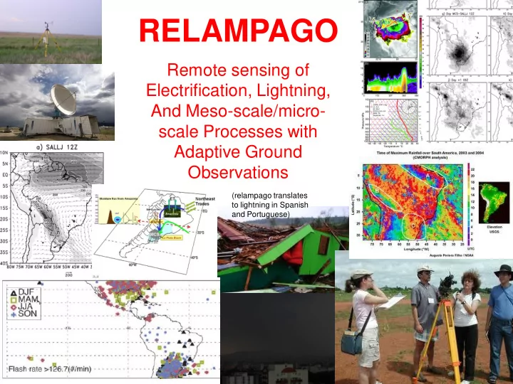
RELAMPAGO
Remote sensing of Electrification, Lightning, And Meso-scale/micro- scale Processes with Adaptive Ground Observations
(relampago translates to lightning in Spanish and Portuguese)
RELAMPAGO Remote sensing of Electrification, Lightning, And - - PowerPoint PPT Presentation
RELAMPAGO Remote sensing of Electrification, Lightning, And Meso-scale/micro- scale Processes with Adaptive Ground Observations (relampago translates to lightning in Spanish and Portuguese) RELAMPAGO (a working acronym) is envisioned to be
(relampago translates to lightning in Spanish and Portuguese)
Zipser et al. 2006 Rasmussen and Houze 2011
Severe weather
Argentina (north of the area indicated by surface-based reports, and more heavily studied in the past) stand out as among the strongest on earth in satellite observations, without having ground-based verification or a strong reputation about the violence of these storms?
for ground-truth-confirmed severe thunderstorms in South America display a loaded-gun profile? Is an elevated mixed layer (leading to early convective inhibition) also observed
thunderstorms? If so, is there an unobserved South American dry line triggering such storms?
and forecasts with new information that might be applicable within and beyond this region?
Cnv wx Hail Gusts Hvy Rain Cecil and Blankenship (2012) Matsudo and Salio (2011)
Cloud microphysics/electrification
reflectivity vertical structure (e.g. high reflectivities near the homogeneous freezing temperature) of storms in the region? Is this structure due to high conditional instability, low entrainment, aerosol environments, or strong mesoscale lift? What are the implications for charging rates in these storms?
dense ice production in these storms lead to unique drop size distributions in these storms (i.e. large drops stabilized by ice cores)?
to enhanced charging and lightning in the anvil and stratiform regions of the storms?
lead to enhanced sprites/TLE production compared with the US Central Plains?
Zipser et al. (2006) Extreme 1%
convective system intensity (vertical structure) and mesoscale organization in the lee of the Andes?
kinematic processes in leading to the upscale growth of convective clouds into MCSs and ultimately MCCs?
convection in the region impact the morphology of the convective systems (or vice versa), and how?
for these processes from
resolving models and regional NWP models represent this morphology from case study to seasonal time scales?
flow features in the region, and how do they dictate the triggering of convective systems and the environment for storms to grow upscale into MCSs?
the LLJ and the evolution of MCSs considering different initiation times?
evolve and generate the initiation of large MCSs over plain areas close to the mountains?
between Amazonia, Paraguay and northern Argentina of biomass aerosols, as well as dust outbreaks from the south. How is the influence of the these aerosols on the development
mesoscale NWP scales to climate models, have very low skill in this region? Are they missing important data for assimilation or are there missing physical processes in numerical models?
gradient in Northern Argentina control the intensity, structure, and predictability of convective systems?
provide for more accurate nowcasting and short term NWP predictions in the region?
limits of predictability on synoptic to intraseasonal time scales for subtropical South American convection?
Ezeiza Canguzu Santiago Parana Pergamino Corboba Anguil Bariloche Asuncion Mendoza Jujuy Bariloche and Cordoba Are the new radars for 2014 C doppler dual pol Ezeiza and Pergamino – C Doppler Parana and Anguil – C – Doppler – Dual Pol Each circle has 480km diameter RELAMPAGO TARGET REGION Target region has: Satellite and ground based indications of severe weather Good roads, connectivity Proximity to soundings and radars
MAJOR CONCERN Need to enhance soundings and surface data collection surrounding convection to capture environment of convective systems and flows they generate Use a combination of mobile/fixed radiosonde sites, cloud drift winds, and pilot balloon observations to form a multi-scale upper observing network Deploy a stick net mobile observation network surrounding convection to capture mesoscale environments and storm-produced flows
S-POL-Ka LMA Mobile StickNet Santiago (BR) Foz de Igacu (BR-DP) Pergamino (AR-DP) Parana (AR-DP) Cordoba (AR-DP) Mendoza (AR) Operational sounding sites RELAMPAGO sounding sites
DOW – used for dual-Doppler
Precip SuperSite NPOL NASA/NOAA Line of disdrometers rain gauges NASA ER-2
Downward looking radar Passive MW Radiometers GLM Airb. Sim.r + LIP Dropsondes
sounding coverage (8 x per day)
– SPOLKa – convective structure and microphysics, refractivity moisture retrievals and cloud water retrivals – NCAR ISS and/or university sounding platforms (U. Alabama/U. Illinois/others?) – DOW for dual-doppler coverage – TTU StickNet or similar platform
– NASA Global Precipitation Measurement (GPM) mission disdrometers, radiometers – Planned discussion with Wayne Higgins (CPC)
– Sounding launch facilities – Sticknet (UFSM) – Lightning mapping array (INPE) – Ground-based electric field mills – EFM balloon profiles/video charge particle measurements (Japan) – High-speed (10,000 fps) video camera
– 2 operational C-Band dual-pol radars (installed by 2014), existing dual-pol radar at Parana – Mobile sounding facility/PIBAL operations – Aerosol /thermodynamics UAV
– Cooperation established, can host instrumentation, possible enhanced radiosonde/PIBAL ops
Science steering group
USA
Brazil
Argentina
Near term plans Will be reaching out to other scientists with observational and modeling interests following the crafting of a white paper in 2013. Seeking WMO World Weather Research Programme (WWRP)/World Climate Research Program (WCRP) endorsement in 2013.