Monday, February 11 th 2019 We lc ome T odays Pr e se ntation - - PDF document
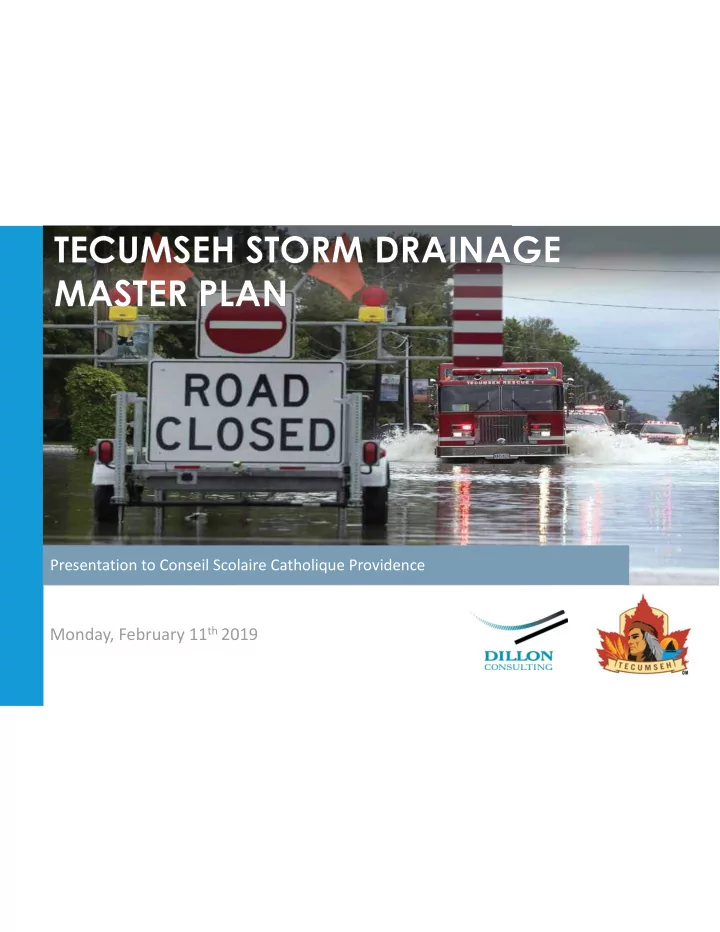
Presentation to Conseil Scolaire Catholique Providence Monday, February 11 th 2019 We lc ome T odays Pr e se ntation Obje c tive s OUTLINE why and how the study is being completed PROVIDE background information and results of the study area
We lc ome
T
- day’s Pr
e se ntation Obje c tive s OUTLINE why and how the study is being completed PROVIDE background information and results of the study area drainage modelling PRESENT the alternative and preferred solutions to reduce surface flooding along
- St. Gregory’s fronting École Secondaire Catholique L'Essor.
SUMMARIZE the next steps in finalizing the study
The Town of Tecumseh is completing a Storm Drainage Master Plan to:
- Identify and address the impacts of surface flooding on the community.
- Identify and evaluate a range of solutions to reduce and minimize the risk of surface flooding.
- Recommend a phased approach to implementation that requires action by the Town and property owners.
- Develop recommendations to ensure no adverse impacts from future development on existing neighbourhoods.
This study does not address the following:
- Basement flooding resulting from sanitary sewer surcharging, which the Town of Tecumseh has been addressing
separately through other studies, initiatives, and subsidy programs since 2010.
- Surface flooding due to high Lake Levels, which is to be addressed in a future study outlined within the Town’s
Flood Mitigation Strategy.
Pr
- je c t Ove r
vie w
Study Stor m Outle ts and Se r vic e Ar e as
Pr
- ble m and Oppor
tunity State me nt
The Town of Tecumseh is completing a Storm Drainage Master Plan to address the impacts of surface flooding on the communities that currently discharge storm water to Lake St. Clair and Pike Creek. This Master Plan will:
- Confirm the factors contributing to surface flooding that exceeds standard depth criteria resulting from significant
storm events.
- Identify and evaluate alternative solutions to reduce the risk and impacts of surface flooding and define
recommended solutions.
- Outline a recommended long-term implementation strategy.
Grace Road: September 2016 Little River Boulevard: September 2016
- St. Gregory’s Road:
September 2016
Study Pr
- c e ss and Sc he dule
The Master Plan is following the requirements of the Municipal Class Environmental Assessment (Class EA) (2000, as amended) - Approach No. 2.
Class E nvir
- nme ntal
Asse ssme nt
The Class EA Process ensures:
- All relevant social, environmental and
engineering factors are considered in the planning and design process.
- Public and agency input is integrated into the
decision making process. The Master Plan will fulfill the requirements of Phases 1 and 2 of the Class EA including the requirements for the noted Schedule B projects.
Sur fac e F looding Conside r ations
Climate Change
- Shift in weather patterns associated
with an increase in global average temperatures.
- The Storm Drainage Master Plan will
look at ways to improve the resiliency
- f drainage infrastructure, taking into
consideration the impacts of climate change and recommend the required level of service.
- A decision matrix is used to
determine a preferred design solution and identify areas that require either a traditional or enhanced level of service.
- Enhanced level of service adds more
resiliency to the storm system, but at a higher capital cost.
TRADITIONAL
Storm Drainage Master Plan Approach
Static design criteria established by regulatory agencies Standard level of service and flood risk mitigation
ENHANCED
Storm Drainage Master Plan Approach
Flexible and sustainable solutions that account for a reasonable degree of uncertainty due to climate change Enhanced and variable level of service and flood risk mitigation
E xisting Condition 1:100 Ye ar Sur fac e F looding We st of Manning R
- ad
E xisting Condition 1:100 Ye ar Sur fac e F looding We st of Manning R
- ad
E xisting Condition 1:100 Ye ar Sur fac e F looding E ast of Manning R
- ad
Public Infor mation Ce ntr e #1 Summar y
During Public Information Centre #1, Tecumseh residents were informed about:
- The causes of both surface and basement flooding;
- Location of problem areas and extent of current surface flooding conditions; and
- Steps being taken to resolve surface flooding, including alternative and preliminary
recommended solutions. Alternatives solutions to alleviate surface flooding included:
- Aboveground and underground storage;
- Improved pump stations;
- Local and trunk storm sewer upgrades; and
- Surface grading improvements.
R e c omme nde d Sur fac e F looding Mitigation Str ate gie s - We st Of Manning R
- ad
REGIONAL PROBLEM AREA ID LOCATION RECOMMENDED FLOODING MITIGATION STRATEGIES (STORM INFRASTRUCTURE IMPROVEMENTS)
STORM TRUNK SEWER LOCAL STORM SEWER ROADWAY GRADING RE-DIRECTION OF STORM DRAINAGE INCORPORATION OF SEWER OVERFLOWS PUMP STATION UNDERGROUND STORAGE SURFACE STORAGE CATHCBASIN INLET EFFICIENCY BACKFLOW PREVENTION
W-1
LESPERANCE ROAD NORTH OF COUNTY ROAD 22, GAUTHIER, EVERGREEN, PAPINEAU
- W-1
- ST. PIERRE STREET
- W-1
MEANDER CRESCENT AND CLAPP STREET
- W-1
LITTLE RIVER DRIVE
- W-1
LACASSE BOULEVARD
- W-1
CORONADO DISH AREA
- W-2
GREEN VALLEY DRIVE AND AMBERLY CRESCENT
- W-3
- ST. ANNE ST BLOCK
SOUTH OF COUNTY ROAD 22
- W-3
LESPERANCE ROAD AND CHARLENE LANE
- LEMIRE STREET/LANOUE
STREET
- Traditional Level of Service Applied
Enhanced Level of Service Applied for Added Resiliency
R e c omme nde d Sur fac e F looding Mitigation Str ate gie s - E ast Of Manning R
- ad
REGIONAL PROBLEM AREA ID LOCATION RECOMMENDED FLOODING MITIGATION STRATEGIES (STORM INFRASTRUCTURE IMPROVEMENTS)
STORM TRUNK SEWER LOCAL STORM SEWER ROADWAY GRADING RE-DIRECTION OF STORM DRAINAGE INCORPORATION OF SEWER OVERFLOWS PUMP STATION SURFACE STORAGE CATHCBASIN INLET EFFICIENCY BACKFLOW PREVENTION
E-1
- ST. GREGORY'S ROAD
- E-1
CADA CRES, FAIRWAY CRES AND GRANT AVE
- E-1
EDGEWATER BLVD
- E-1
- ST. MARK'S ROAD
- E-1
ARLINGTON BLVD
- E-1
Riverside Drive
- E-1
KENSINGTON DISH AREA
- TECUMSEH ROAD
- STARWOOD
LANE/SOUTHWIND CRESCENT
- Traditional Level of Service Applied
Enhanced Level of Service Applied for Added Resiliency
Sc he dule B Pr
- je c t Summar
y
The Tecumseh Storm Drainage Master Plan followed the requirements of Approach #2 of the Class EA and has identified alternative solutions to address surface flooding. The evaluation of solutions took into consideration the existing environment and improvements to the system to establish preferred solutions which took into account both public and review agency input. Provided below is a list of the Schedule B projects determined through this study: Pump Station Improvements
- Construction of a new storm pump station at the Lesperance pump station site;
- Expansion of the West St. Louis pump station;
- Decommission of the St. Mark’s storm pump station and construction of a new consolidated storm pump
station at the existing Scully pump station site;
- Construction of a new storm pump station and outlet at the PJ Cecile pump station site; and
- Incorporation of a new storm pump station along Southwind Crescent.
Underground/Aboveground Storage
- Incorporate surface storage within the “Tecumseh Soccer Fields” owned by École Secondaire L'Essor;
- Incorporate surface storage within municipal owned Buster Reaume Park; and
- Incorporate underground/surface storage behind municipal owned Tecumseh Town Hall property.
R e c omme nde d Sur fac e F looding Mitigation Str ate gie s - E ast Of Manning R
- ad
SCHEDULE B ALTERNATIVES: ST. GREGORY’S ROAD LOCAL SOLUTION
ALTERNATIVE 1 (aboveground storage outside of roadway) ALTERNATIVE 1 ALTERNATIVE 2 ADVANTAGES
- Effective solution for surface flooding within localized
problem area.
- Limited traffic disruption during construction.
- Does not disrupt use of soccer fields.
- No maintenance easement required along private property.
- Greater level of service for storm sewer conveyance during more
frequent storm events.
DISADVANTAGES
- Temporary disruption to soccer fields during construction
and during storm events beyond a 1:100 year rainfall.
- Maintenance easement required around depressed area.
- Higher capital cost than Alternative 1.
- Difficult to construct: Utility conflicts within the roadway.
- Higher traffic disruption during construction
EVALUATION OF ALTERNATIVES
ALTERNATIVE 2 (underground storage within roadway)
RECOMMENDED SOLUTION
R e c omme nde d Sur fac e F looding Mitigation Str ate gie s - E ast Of Manning R
- ad
LOCALIZED SOLUTIONS
Surface Storage (Enhanced Level of Service) Storm Sewer Conveyance, Road Grading and Catchbasin Improvements Overflow Sewer Backflow Prevention
A B C
RECOMMENDED DESIGN: ST. GREGORY’S ROAD LOCAL SOLUTION
A B C D
D Bottom = 176.00m
Sur fac e F looding Compar isons
Existing 1:100yr Surface Flooding Future 1:100 year Surface Flooding Existing 1:100 year + 40% Surface Flooding Future 1:100 year + 40% Surface Flooding
Maximum roadway surface ponding depth of 0.20m Maximum roadway surface ponding depth of 0.30m
Ne xt Ste ps
Continue public and agency consultation and review comments arising from PIC#2. Consider Public/Agency input in refining/continuing the recommended solutions Prepare the long-term implementation strategy Finalize the Storm Drainage Master Plan Report (April 2019) and issue Notice of Completion. The Plan will be presented to Council and will be available for a 30-day public review period.
THANK YOU FOR ATTENDING
Your input is important to the outcome of this study. Please complete a comment form or send comments to tecumsehdrainagemp@dillon.ca
From: McLeod, Brad <bmcleod@dillon.ca> Date: Fri, Dec 7, 2018 at 11:15 AM Subject: Information Request - Town of Tecumseh Pump Station Locations To: ESA-Aylmer (MNRF) <ESA.Aylmer@ontario.ca> Cc: Flavio Forest <fforest@dillon.ca>, Ryan Langlois <rlanglois@dillon.ca>, Mark Brobbel <mbrobbel@dillon.ca>, 164880 <164880@dillon.ca>
Morning, Dillon is currently seeking information for seven pump station properties located in the Town of Tecumseh, Essex County, Ontario (see attached figures; 12280 Riverside Drive, 12920 Riverside Drive, 13079 and 13102 Riverside Drive, 13698 Riverside Drive, 13770 Riverside Drive, 14080 Riverside Drive, and 262 and 270 Brighton Road). At this time, we kindly ask that you provide relevant SAR information for the areas identified, as well as any
- ther information you may have on natural heritage features (PSW's, ANSI's, etc.), species of conservation
concern, fish dot records, etc. If you have any questions, please feel free to give me a call. Thank you
Brad McLeod, M.S. Dillon Consulting Lim ited 3200 Deziel Drive Suite 608 Windsor, Ontario, N8W 5K8 T - 519.948.5000 ext. 3250 C - 519.791.0855 F - 519.948.5054 BMcLeod@dillon.ca www.dillon.ca Please consider the environment before printing this email
7Attachments
Figure 1 12280 Riv… Figure Figur 1 122 122 Figure 2 12920 Riv… Figure Figur 2 129 2 129 Figure 3 13079_13… Figure Figur 3 130 3 130 Figure 4 13698 Riv… Figure Figur 4 136 4 136 Figure 5 13770 Riv… Figure Figur 5 137 5 137 Figure 6 14080 Riv… Figure Figur 6 140 6 140 Figure 7 262_270 … Figure Figur 7 262 7 262
Town of Tecumseh
Tecumseh Master Drainage Study
12280 Riverside Dr (Lesperance Road Pump Station)
FIGURE 1
10 20 5 Meters
²
MAP DRAWING INFORMATION: DA TA PROVIDED BY MNR MAP CREATED BY: PFM MAP CHECKED BY: PK MAP PROJECTION: NAD 1983 UTM Zone 17N FILE LOCA TION: \\DILLON.CA\DILLON_DFS\LONDON\LONDON CAD\ GIS\VISUAL COMMUNICATIONS DI\MXD TEMPLATES\ GREY - 8.5X11 LANDSCAPE - LEGEND BOTTOM.MXD PROJECT: 11-1234 STA TUS: DRAFT DA TE: 08/24/11
ELC OAO - Open Aquatic CGL - Green Lands
Town of Tecumseh
Tecumseh Master Drainage Study
12920 Riverside Dr (West St. Louis Pump Station)
FIGURE 2
10 20 5 Meters ² MAP DRAWING INFORMATION: DA TA PROVIDED BY MNR MAP CREATED BY: PFM MAP CHECKED BY: PK MAP PROJECTION: NAD 1983 UTM Zone 17N FILE LOCA TION: \\DILLON.CA\DILLON_DFS\LONDON\LONDON CAD\ GIS\VISUAL COMMUNICATIONS DI\MXD TEMPLATES\ GREY - 8.5X11 LANDSCAPE - LEGEND BOTTOM.MXD PROJECT: 11-1234 STA TUS: DRAFT DA TE: 08/24/11
ELC OAO - Open Aquatic CGL - Green Lands
Town of Tecumseh
Tecumseh Master Drainage Study
13079, 13102 Riverside Dr (East St. Louis Pump Station)
FIGURE 3
10 20 5 Meters
²
MAP DRAWING INFORMATION: DA TA PROVIDED BY MNR MAP CREATED BY: PFM MAP CHECKED BY: PK MAP PROJECTION: NAD 1983 UTM Zone 17N FILE LOCA TION: \\DILLON.CA\DILLON_DFS\LONDON\LONDON CAD\ GIS\VISUAL COMMUNICATIONS DI\MXD TEMPLATES\ GREY - 8.5X11 LANDSCAPE - LEGEND BOTTOM.MXD PROJECT: 11-1234 STA TUS: DRAFT DA TE: 08/24/11
ELC OAO - Open Aquatic CGL - Green Lands
Town of Tecumseh
Tecumseh Master Drainage Study
13698 Riverside Dr (Skully Pump Station)
FIGURE 4
10 20 5 Meters
²
MAP DRAWING INFORMATION: DA TA PROVIDED BY MNR MAP CREATED BY: PFM MAP CHECKED BY: PK MAP PROJECTION: NAD 1983 UTM Zone 17N FILE LOCA TION: \\DILLON.CA\DILLON_DFS\LONDON\LONDON CAD\ GIS\VISUAL COMMUNICATIONS DI\MXD TEMPLATES\ GREY - 8.5X11 LANDSCAPE - LEGEND BOTTOM.MXD PROJECT: 11-1234 STA TUS: DRAFT DA TE: 08/24/11
ELC OAO - Open Aquatic CGL - Green Lands
Source: Esri, DigitalGlobe, GeoEye, Earthstar Geographics, CNES/Airbus DS, USDA, USGS, AeroGRID, IGN, and the GIS User Community
Town of Tecumseh
Tecumseh Master Drainage Study
13770 Riverside Dr (St. Mark's Pump Station)
FIGURE 5
10 20 5 Meters
²
MAP DRAWING INFORMATION: DA TA PROVIDED BY MNR MAP CREATED BY: PFM MAP CHECKED BY: PK MAP PROJECTION: NAD 1983 UTM Zone 17N FILE LOCA TION: \\DILLON.CA\DILLON_DFS\LONDON\LONDON CAD\ GIS\VISUAL COMMUNICATIONS DI\MXD TEMPLATES\ GREY - 8.5X11 LANDSCAPE - LEGEND BOTTOM.MXD PROJECT: 11-1234 STA TUS: DRAFT DA TE: 08/24/11
ELC OAO - Open Aquatic CGL - Green Lands
Town of Tecumseh
Tecumseh Master Drainage Study
14080 Riverside Dr (Peter Cecile Pump Station)
FIGURE 6
10 20 5 Meters
²
MAP DRAWING INFORMATION: DA TA PROVIDED BY MNR MAP CREATED BY: PFM MAP CHECKED BY: PK MAP PROJECTION: NAD 1983 UTM Zone 17N FILE LOCA TION: \\DILLON.CA\DILLON_DFS\LONDON\LONDON CAD\ GIS\VISUAL COMMUNICATIONS DI\MXD TEMPLATES\ GREY - 8.5X11 LANDSCAPE - LEGEND BOTTOM.MXD PROJECT: 11-1234 STA TUS: DRAFT DA TE: 08/24/11
ELC OAO - Open Aquatic CGL - Green Lands
Town of Tecumseh
Tecumseh Master Drainage Study
262, 270 Brighton Rd (Brighton Road Pump Station)
FIGURE 7
10 20 5 Meters
²
MAP DRAWING INFORMATION: DA TA PROVIDED BY MNR MAP CREATED BY: PFM MAP CHECKED BY: PK MAP PROJECTION: NAD 1983 UTM Zone 17N FILE LOCA TION: \\DILLON.CA\DILLON_DFS\LONDON\LONDON CAD\ GIS\VISUAL COMMUNICATIONS DI\MXD TEMPLATES\ GREY - 8.5X11 LANDSCAPE - LEGEND BOTTOM.MXD PROJECT: 11-1234 STA TUS: DRAFT DA TE: 08/24/11
ELC OAO - Open Aquatic CVR - Residential