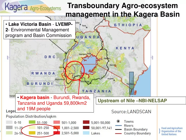
SLIDE 1 Upstream of Nile –NBI-NELSAP
- Kagera basin - Burundi, Rwanda,
Tanzania and Uganda 59,800km2 and 19M people
- Lake Victoria Basin - LVEMP-
2- Environmental Management program and Basin Commission
Transboundary Agro-ecosystem management in the Kagera Basin
SLIDE 2
Pressures on land resources in the Kagera basin
Bush burning
SLIDE 3
State: Degradation (soil erosion & fertility loss, less water quality & flow, loss of vegetation cover, biodiversity & ecosystem functions) Impacts: poverty, food insecurity, conflict over resources, youth out-migration (labour shortage)
Kagera Basin Challenges
To treat these symptoms we need to address the cause ses Direct Pressures: reduced farm size, fragmented, poor land use/
management practices, differential access (herds; land) conflict
Drivers: population growth, market driven crop/ livestock intensification
(urban demand), low knowledge base, lack of support (policy, incentives)
SLIDE 4 Theory of change from a degradation scenario to adoption and buy in of integrated SLaM
approach
- to restore degraded lands and
improve productivity
- to sequester carbon and adapt to
climate change
- to conserve agro-biodiversity and
ensure its sustainable use
- to improve food security and rural
livelihoods
- and thereby, contribute to the
protection of international waters
- 1. Support for SLM adoption for range of land uses and land user types (FFS
grants, facilitation/extension, technical support teams, investment)
- 2. Capacity developed at all levels: farmers, technicians, decision makers.
- 3. Participatory Land Planning: farm-catchment-community bye laws, district
- 4. Transboundary Cooperation & harmonisation
SLIDE 5 DRIVING FORCES (indirect causes)
Diagnostics using DPSIR Framework
PRESSURES (direct causes) STATE OF THE LAND (processes) IMPACTS (on ecosystem services) IMPACTS (on livelihood assets) RESPONSES Vegetation, soil, water
Drivers Pressures Status and trends Impacts Responses
Build understanding
for each land use type and for each land user group
SLIDE 6 Z A
Soil erosion / soil properties Vegetation Water resources
Transect
LADA local assessment- Characterize
the area/catchment, status and trends of vegetation, soil, water Compare good and poor land use and management practices Responses & their Impacts on ES
SLIDE 7 Key Informant & land user typology and HH livelihoods assessment
Interviews with sample households in catchment Score each asset for interviewed households
- Natural assets- land area, land quality, trees, …
- Physical assets- access to transport, market …
- Human assets- education level, knowledge
- Social assets- water users organisation, FFS …
- Financial assets- capital, access to credit/bank
Draw asset pentagons to compare the assets (& capacities) of the different land user profiles and trends Better off Average Poor
SLIDE 8
Field visits to select best practices (Tanzania)
Visits with locals and extension and FFS study plots to select and adapt existing crop, grazing, tree, forest and livestock management practices
SLIDE 9
Identify, Assess and Document SLM Technologies and Approaches using WOCAT
SLIDE 10
SLIDE 11
Well made ridges on a radical terrace planted with Round potato for Umurava FFS group field FFS group agroforestry tree nursery, Kamonyi district FFS group dynamics Ballet box to assess knowledge change
FFS Learning & Experimentation Range of SLAM interventions
SLIDE 12
- Bring together FFS approach, catchment
planning & management and bye laws/ local governance
- Identify, assess and document best practices
using WOCAT tools (QA, QT),
- Share best practices through WOCAT database
and pilot QW and QC
- Asses and raise awareness understanding on
multiple benefits of SLM:
- Productivity,
- CC A&M, short and long term resilience
- Agro-biodiversity (diverse genetic resources,
species and habitats- pollination, pest control etc)
- Food security and nutrition
- Sustaining ecosystem services (C, nutrients
water, flood & drought management)
http://www.fao.org/in-action/kagera/home/en/a www.fao.org/landandwater
Integrated landscape/production systems for multiple benefits and resilience