Joint Review Board Meeting February 6, 2018 10:00 AM Sources: ESRI, - - PowerPoint PPT Presentation

joint review board meeting
SMART_READER_LITE
LIVE PREVIEW

Joint Review Board Meeting February 6, 2018 10:00 AM Sources: ESRI, - - PowerPoint PPT Presentation

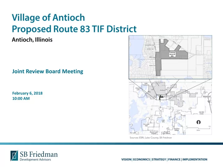
Joint Review Board Meeting February 6, 2018 10:00 AM Sources: ESRI, Lake County, SB Friedman The RPA comprises vacant property RPA characteristics 73 acres 58 acres of vacant land 15 acres of right-of-way


slide-1
SLIDE 1

Joint Review Board Meeting

February 6, 2018 10:00 AM

Sources: ESRI, Lake County, SB Friedman

slide-2
SLIDE 2
slide-3
SLIDE 3
  • The RPA comprises vacant

property

  • RPA characteristics

73 acres

  • 58 acres of vacant land
  • 15 acres of right-of-way

19 parcels

  • 10 vacant parcels
  • 9 right-of-way parcels

(excluded from eligibility)

Two subdivisions were recorded on 11/1/2017

  • Eligibility analyzed using

existing tax parcels at the time of analysis (June 2017)

Sources: ESRI, Lake County, SB Friedman

slide-4
SLIDE 4

Two Paths to Blighted Eligibility for “Vacant” Land

  • At least two (2) of 6 possible factors

must be present to a meaningful extent and reasonably distributed

  • Potential factors
  • Obsolete platting of vacant land
  • Diversity of ownership
  • Tax and special assessment delinquencies
  • Deterioration of structures or site

improvements in neighboring areas adjacent to the vacant land

  • Environmental contamination
  • Lack of growth in equalized assessed value

(“EAV”)

  • At least one (1) of 6 possible factors

must be present to a meaningful extent and reasonably distributed

  • Potential factors
  • The area contains unused quarries, strip mines or

strip mine ponds

  • The area contains unused rail yards, rail track, or

railroad rights-of-way

  • The area, prior to its designation, is subject to or

contributes to chronic flooding

  • The area contains unused or illegal dumping sites
  • The area was designated as a town center prior to

January 1, 1982, is between 50 and 100 acres, and is 75% vacant land

  • The area qualified as blighted prior to becoming

vacant

slide-5
SLIDE 5
  • Collected parcel-level data from Lake County
  • Conducted parcel-by-parcel fieldwork to document external property

conditions

  • Analyzed historic trends in property value (EAV) from 2012-2017
  • Compiled and analyzed all data using GIS to evaluate eligibility factors
  • Evaluated evidence of private investment prior to TIF district designation
  • Reviewed current Village Comprehensive Plan
slide-6
SLIDE 6

The RPA qualifies as a “Blighted Area” based on the following two (2) eligibility factors:

  • 1. Lack of Growth in Equalized Assessed Value (“EAV”)
  • 2. Adjacent Deterioration
slide-7
SLIDE 7

SOURCE: Lake County Assessor’s Office; SB Friedman; U.S. Bureau Of Labor Statistics, Chicago-Gary-Kenosha, IL-IN-WI, All Consumer Items. Analysis updated with revised EAV January 2018. [1] CPI Based on monthly average through August 2017

Percent Change in Annual Equalized Assessed Value (“EAV”)

  • For three of the last five year-to-year periods, the total EAV of the area must have

either: a) Declined; b) Increased at an annual rate that is less than the balance of the Village; or c) Increased at a rate that is less than the Consumer Price Index (CPI) for All Urban Consumers

  • EAV increased at a rate less than CPI
  • Area-wide factor

2012 - 2013 2013-2014 2014-2015 2015-2016 2016-2017 RPA Parcels

  • 1.6%

0.1%

  • 3.8%

2.8%

  • 72.9%

Decline in RPA EAV YES NO YES NO YES Consumer Price Index (CPI) 1.1% 1.7%

  • 0.3%

0.7% 1.6% [1] RPA Parcels Growth Less than CPI YES YES YES NO YES

slide-8
SLIDE 8
  • Parcels throughout RPA are adjacent

to deterioration, including:

  • Cracked and crumbling roadway
  • n Grimm Road
  • Cracked and alligatoring of

parking surfaces on adjacent property

  • Uneven parking surfaces and

puddling

  • Cracked building foundation
  • This factor was found to be present
  • n 10 out of 10 (100%) vacant land

parcels within the RPA

Cracking in the private drive of an adjacent parcel Cracking/crumbling in Grimm Road Sources: ESRI, Lake County, SB Friedman

slide-9
SLIDE 9
  • Lack of growth and private investment

EAV increased at a rate that is less than the CPI in four of the last five year-to-year periods

No building permit activity over the last five years

  • But for…

But for the creation of a TIF district, critical resources would be lacking that would

  • therwise support the redevelopment of the TIF district, and the TIF district would not

reasonably be anticipated to be developed

  • RPA includes only the contiguous real property that is expected to

substantially benefit from the TIF District

  • Conformance to Village Plans

Future land use conforms with the Village’s Comprehensive Plan from 1991

slide-10
SLIDE 10
  • Replacement, repair, construction and/or improvement of public

infrastructure (utilities, sidewalks, streets, curbs, underground water and sanitary systems, and stormwater)

  • Streetscaping, landscaping and signage to improve image, attractiveness and

accessibility

  • Support the goals and objectives of other overlapping plans:

Including the 2017-2020 Strategic Plan Summary Report and the Comprehensive Plan

  • Coordinate available federal, state and local resources to further the goals of

the Redevelopment Plan and Project

slide-11
SLIDE 11

[1] See Redevelopment Plan for additional details.

Project/Improvement [1] Estimated Project Costs

Administration and Professional Service Costs $2,000,000 Site Marketing Costs $500,000 Property Assembly and Site Preparation Costs $6,500,000 Costs of Building Rehabilitation $200,000 Costs of Construction of Public Works or Improvements $13,000,000 Costs of Job Training or Retraining (Businesses) $200,000 Financing Costs $600,000 Taxing District Capital Costs $200,000 Relocation Costs $200,000 Payments in Lieu of Taxes $200,000 Costs of Job Training (Community College) $200,000 Interest Costs (Developer or Property Owner) $200,000 TOTAL REDEVELOPMENT PROJECT COSTS $24,000,000

slide-12
SLIDE 12

The mixed-use designation allows for the following land uses within the RPA:

  • Commercial

(Retail/Office/Service)

  • Industrial
  • Right-of-Way
  • Conservation Areas
slide-13
SLIDE 13
slide-14
SLIDE 14