
SLIDE 1
| |
ICC Dresden 2013
August/2013
- I. Iosifescu & L. Hurni
Institute of Cartography and Geoinformation, ETH Zurich, Switzerland
1
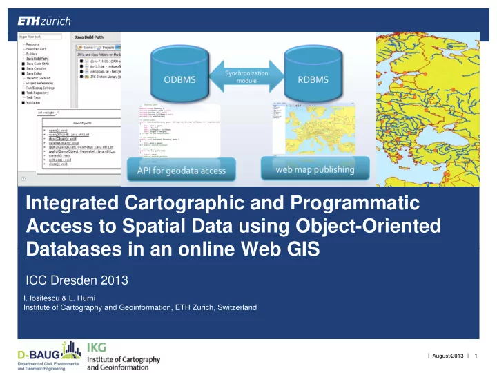
Integrated Cartographic and Programmatic Access to Spatial Data - - PowerPoint PPT Presentation
Integrated Cartographic and Programmatic Access to Spatial Data using Object-Oriented Databases in an online Web GIS ICC Dresden 2013 I. Iosifescu & L. Hurni Institute of Cartography and Geoinformation, ETH Zurich, Switzerland | |
| |
August/2013
Institute of Cartography and Geoinformation, ETH Zurich, Switzerland
1
| |
August/2013
2
| | August/2013
3
| | August/2013
4
| | August/2013
5
| |
August/2013
6
| | August/2013
7
| | August/2013
8
Synchronization module Synchronization module
| | August/2013
9
| | August/2013
10
| | August/2013
11
| | August/2013
12
| | August/2013
13
| | August/2013
14
| | August/2013
15
// opening the API GeoObjects.open(); // create a new point geometry for the query GeometryFactory geometryFactory = new GeometryFactory(); WKTReader reader = new WKTReader( geometryFactory ); Point point = null; try { // we assume that a GeocodedAddress object is available point = (Point) reader.read("POINT (" + GeocodedAddress.getLat() + " " + GeocodedAddress.getLong() + ")"); } catch (ParsingException e) { //handle exception in parsing the coordinates } if (point != null) { // define the geometry of the buffer for the neighbouring query area as desired Geometry geom = point.buffer(0.025); // retrieve the objects of interest from the immediate area sensors_list = GeoObjects.spatialQuery(Sensor.class, geom); // implement the application logic as needed or simply display the query results } // closing the API GeoObjects.close();
| |
August/2013
16
| |
August/2013 17