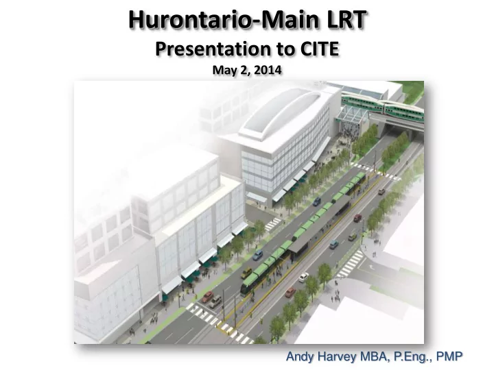
Hurontario-Main LRT Presentation to CITE May 2, 2014 Andy Harvey - - PowerPoint PPT Presentation

hurontario main lrt
SMART_READER_LITE
LIVE PREVIEW

Hurontario-Main LRT Presentation to CITE May 2, 2014 Andy Harvey - - PowerPoint PPT Presentation

Hurontario-Main LRT Presentation to CITE May 2, 2014 Andy Harvey MBA, P.Eng., PMP Agenda Introduction Background Context LRT Update Closing Comments Mississauga: Strategic Location Mississauga City of Mississauga


slide-1
SLIDE 1

Hurontario-Main LRT

Presentation to CITE

May 2, 2014

Andy Harvey MBA, P.Eng., PMP

slide-2
SLIDE 2

Agenda

  • Introduction
  • Background
  • Context
  • LRT Update
  • Closing Comments
slide-3
SLIDE 3

Mississauga: Strategic Location

slide-4
SLIDE 4
  • City of Mississauga

– Incorporated 1974 – Canada’s 6th Largest City – Population 741,000 – Employment 422,000 – 60 of Canada’s Fortune 500

Mississauga

slide-5
SLIDE 5

Mississauga - THEN

Mississauga City Centre, 1970’s

slide-6
SLIDE 6

Mississauga - NOW

Mississauga City Centre, 2009

slide-7
SLIDE 7

Port Credit to Sunnyside Streetcar

slide-8
SLIDE 8

Port Credit to Sunnyside Streetcar

slide-9
SLIDE 9

Mississauga, 2009 New York, 1880

Old Ideas are New Again

slide-10
SLIDE 10

Competing Interests

Landscape

Trucks

Cars

Transit Seniors

Construction Maintenance Snow Clearing

Freeways

School Zone Railways Parade

Jurisdiction Environment Multi Use Trails

Region

Province

Federal Utilities

slide-11
SLIDE 11

Accommodating Needs

slide-12
SLIDE 12

Accommodating Needs

slide-13
SLIDE 13
slide-14
SLIDE 14

14

How The City Works

slide-15
SLIDE 15

Leadership

slide-16
SLIDE 16

Transportation Master Plan

  • 2031 Time Horizon Analysis
  • Vision, Goals, Principles
  • Multi-modal approach to issues
  • Best practices, policies, and programs
  • Micro-simulation and detailed analysis

Typical Approach Mississauga Approach

Typical Class EA approach to a City-wide TMP is not practical for a built-out municipality that needs to retro-fit the road network to be multi-modal

  • 2031 Time Horizon
  • Provides the basis for how transportation funding is spent
  • Uses Municipal Class Environmental Assessment Guidelines
  • Uses traditional strategic transportation modeling tools
slide-17
SLIDE 17

2031 Network Conditions

Driving Factors

  • Significant growth

surrounding Mississauga

  • Increase in 905-to-905

travel patterns

  • Increasing traffic outside

the traditional morning and evening rush hour periods

2031 Percentage Increase In GTHA Population Growth

slide-18
SLIDE 18

Transportation In the GTHA

If Current Trends Continue………

  • Average time spent commuting will increase from 82 minutes to 109 minutes
  • Travel time by car from Hamilton to Downtown Toronto will take approximately 3 hours
  • Annual cost of congestion to the GTHA economy will increase from $2.7 billion to $7.2

billion

Source: Ontario Ministry of Transportation GGH Transportation Model, Metrolinx “The Big Move”

slide-19
SLIDE 19

Travel Time In Mississauga

If Current Trends Continue……..

Source: City of Mississauga Transportation Model For AM Peak Period

slide-20
SLIDE 20

MOVE – The need for improved mobility

slide-21
SLIDE 21
slide-22
SLIDE 22
slide-23
SLIDE 23

DO DOWNT WNTOWN21 WN21 PRINCIPL PRINCIPLES ES

slide-24
SLIDE 24

Overall New Street Network Existing Network

New Network

slide-25
SLIDE 25

Hurontario Rathburn

Confederation

Cleary Park Main Street Sussex Mississauga Valley Square One Civic

Create Districts

slide-26
SLIDE 26

Population Units Employment Office (sf) PPJ/Ha Parks (ha) Today 30,000 14,000 19,000 3,600,000 176 19.57 DT21 Master Plan 72,000 33,000 72,000 16,000,000 487 32.73 2031 Hemson Forecast 61,000 27,000 35,000 5,700,000 325

slide-27
SLIDE 27

Placemaking Objectives Business Case

Business Plan

slide-28
SLIDE 28

HURONTARIO-MAIN LRT PROJECT

slide-29
SLIDE 29

Metrolinx and the Big Move

slide-30
SLIDE 30

Metrolinx

slide-31
SLIDE 31

Metrolinx

slide-32
SLIDE 32

Corridor Master Plan (2010)

Guiding Principles for the Project

The Vision for Hurontario-Main LRT Project

  • Light Rail Transit (LRT) system providing fast and efficient public transit

corridor wide - connecting to various east-west local/regional systems.

  • A vibrant sustainable beautiful street
  • Shift the focus from moving vehicles to moving people *
slide-33
SLIDE 33
  • Intensification corridor that connects

Mississauga/ Brampton Urban Growth Centres

  • Linkages to GO network and 5 Mobility Hubs

Urban Growth Centre Urban Growth Centre

Hurontario/Main Street Corridor

slide-34
SLIDE 34

Transit Oriented Development transit parking

pedestrian cycle

extended tree canopy active uses at grade level active public realm wider sidewalks enhanced crosswalks

Hurontario-Main Corridor

slide-35
SLIDE 35

critical mass of people and activities consistent building podium (street-wall) distinct streetscaping buildings face the street with active uses at grade level pedestrian crossings at regular intervals integrated rapid transit system

Hurontario-Main Corridor

slide-36
SLIDE 36

Presentation Scope

PHASE2: Preliminary Design and Transit Project Assessment Process

  • High frequency urban styled Light Rail

Transit

  • Connecting Brampton and Mississauga

from north to south with key transit links and major destinations

  • 26 stops spaced approximately 800m

apart

slide-37
SLIDE 37

Modern, Electrically Powered, Urban-style LRT

slide-38
SLIDE 38

Proven to Operate in All Weather Conditions

slide-39
SLIDE 39

Designated Lanes (Segregation) for Speed and Reliability

slide-40
SLIDE 40

LRT Priority- Re-allocating Road Space

slide-41
SLIDE 41

LRT Stops

41

slide-42
SLIDE 42

A Complete Street Design Approach

slide-43
SLIDE 43

TOD Development

slide-44
SLIDE 44

Access to LRT

slide-45
SLIDE 45

Integrate Into Neighbourhoods

slide-46
SLIDE 46

Typical LRT Stop Layout

slide-47
SLIDE 47

Simple Stops, Easy to Integrate

slide-48
SLIDE 48

Low Floor Level Boarding- Access for All

slide-49
SLIDE 49

Easy Transit Transfer

slide-50
SLIDE 50

LRT and the Public Realm

slide-51
SLIDE 51

Colour and Style help define “City Style”

slide-52
SLIDE 52

A Complete Street Design Approach

slide-53
SLIDE 53

Main Street Mathews Gate Robert Speck Rathburn Civic

Lots of Challenges

slide-54
SLIDE 54

Downtown Mississauga Movement Plan

slide-55
SLIDE 55

Project Schedule Next Steps

slide-56
SLIDE 56

Transit Project Assessment Process

  • Assesses the potential

environmental impacts, including:

  • Noise
  • Air Quality
  • Traffic
  • Cultural and Natural

Heritage

  • Socio-economic

impacts

  • Approved by the Minister of

the Environment

  • Establishes commitments

for work to be completed during implementation

slide-57
SLIDE 57

CHALLENGES

Mineola: Character, Traffic, Access , transition zones

slide-58
SLIDE 58

QEW: Existing QEW: With LRT

slide-59
SLIDE 59

Hwy 403: LRT Design Hwy 403: Existing

slide-60
SLIDE 60

Rathburn Road: Existing

slide-61
SLIDE 61

Rathburn Road: LRT Design

slide-62
SLIDE 62

Duke of York Blvd: Existing

slide-63
SLIDE 63

Duke of York Blvd: Existing

slide-64
SLIDE 64
  • Hwy. 407: Existing

Hwy 407: LRT Design

slide-65
SLIDE 65

Maintenance and Storage Facility (MSF)

slide-66
SLIDE 66

Brampton Heritage

slide-67
SLIDE 67

Brampton Downtown

slide-68
SLIDE 68

Utilities

slide-69
SLIDE 69

Developing a Complete Street- Existing Condition

Traffic dominated low density development

slide-70
SLIDE 70

Developing a Complete Street –Introducing LRT

Re-allocated road space for segregated LRT

slide-71
SLIDE 71

Developing a Complete Street –The full package

Segregated LRT, higher people-capacity corridor Higher density TOD development

slide-72
SLIDE 72

Eglinton Today

slide-73
SLIDE 73

Eglinton Stop Full Buildout

slide-74
SLIDE 74

Overhead Wires Mixed Use Development Simple Shelter Driver Controlled Low-level Platform Step free access Rail level with surfacing

Desirable Elements

slide-75
SLIDE 75

a) PIC #1 – Future LRT

Burnhamthorpe Today

slide-76
SLIDE 76

a) PIC #1 – Future LRT

Burnhamthorpe Initial LRT

slide-77
SLIDE 77

c) PIC #2 - Ultimate

Burnhamthorpe Station

slide-78
SLIDE 78

Port Credit GO station Today

slide-79
SLIDE 79

Port Credit GO Station With LRT

slide-80
SLIDE 80

Dundas Street Today

slide-81
SLIDE 81

Dundas Street LRT Stop

slide-82
SLIDE 82

Cooksville Stop - Ultimate

Cooksville GO Ultimate

slide-83
SLIDE 83

TITLE

slide-84
SLIDE 84

Transit Today

slide-85
SLIDE 85

Transit Tomorrow

slide-86
SLIDE 86

Traffic Management

slide-87
SLIDE 87

Smart Bus/Smart LRT

slide-88
SLIDE 88 City of Mississauga WAN 1 5 C i t y C e n t r e

400 Fixed Route Buses City Data Centre

OnStreet /

12 Supervisor Vehicles 20 Operator Relief Cars 4 Service Trucks

Signal Priority Arrival Departure Information at Transit Centers

3555 Enrindale Station Rd 975 Central Parkway

WLAN WLAN 1 5 C i t y C e n t r e 1 5 C i t y C e n t r e 1 5 C i t y C e n t r e 1 5 C i t y C e n t r e

Back up Work Station 6780 Professional Court 4th Garage for the Future Primary Dispatch 975 Central Parkway

Workstations

1 5 C i t y C e n t r e

15 BRT Buses Redundant System Location

Supervisor Laptop

V M S a t K e y L

  • c

a t i

  • n

s HP C-Class Blade Center SAN

Phase 3

HastInfo

Smart Bus

Wireless

slide-89
SLIDE 89

Transportation Demand Management (TDM)

slide-90
SLIDE 90
slide-91
SLIDE 91

Stay On-track With Us

Questions