Humber Creek Erosion Control Chapman Valley Park Class - - PowerPoint PPT Presentation
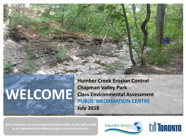
Humber Creek Erosion Control Chapman Valley Park Class Environmental Assessment PUBLIC INFORMATION CENTRE July 2018 Your comments are encouraged and appreciated, as this will provide us an opportunity to address project issues and concerns.
Humber Creek Erosion Control Class Environmental Assessment
PURPOSE OF TONIGHT’S MEETING
To gain community input on:
- Existing conditions information
- Identification of opportunities and restoration
preferences
- Alternative evaluation criteria and scoring
This Public Information Centre (PIC) is Designed to:
- Present information on existing conditions
- Present alternative approaches to restoration
- Present evaluation approach
- Present study process and timelines
2
Humber Creek Erosion Control Class Environmental Assessment
STUDY PURPOSE / PROBLEM DEFINITION
The study is being carried out because channel erosion and deterioration of the Humber Creek corridor has created risks to the environment, sanitary sewer infrastructure, private properties, and public safety.
STUDY OBJECTIVES
3
- Reduce channel erosion and stabilize slopes in the Humber Creek corridor
- Restore reaches and repair deteriorated storm outfalls in the Humber Creek
- Protect exposed or at risk City sewer infrastructure within the Humber
Creek corridor
- Improve aquatic habitat and fish passage in the Humber Creek
Humber Creek Erosion Control Class Environmental Assessment
STUDY AREA
The study area includes the portion of the Chapman Valley spanning from a city right-of-way connecting the Leggett Avenue to Westmount Park Road, to the confluence with the Lower Humber River. The general extents are shown on the figure below, with the sanitary sewer lines in red and storm sewers in green.
Humber Creek
Humber Creek Erosion Control Class Environmental Assessment
MUNICIPAL CLASS ENVIRONMENTAL ASSESSMENT PROCESS
CLASS EA PROCESS - SCHEDULE B Many projects related to municipal systems are similar in nature, are carried out routinely, and have predictable and mitigatable environmental effects which are investigated according to the Municipal Engineers Association “Municipal Class Environmental Assessment” (October 2000, as amended in 2007 & 2015). This study is being undertaken as a Schedule B project under the Municipal Class Environmental Assessment process. The flow chart illustrates the key steps to be undertaken as part of the EA process.
5
Phase 1 – Identify Problems
Identify Problem or Opportunity Public Consultation
Phase 2 – Alternate Solutions
Identify Alternative Solutions Inventory Natural, Social, Economic Environment Environmental Impacts and Mitigation Alternatives Evaluation Review Agency and Public Consultation Select Preferred Solution Review and Confirm Choice of Schedule Notice of Completion to Review Agency & Public Implementation
We Are Here
Humber Creek Erosion Control Class Environmental Assessment
EXISTING CONDITIONS
A B A Confluence of Humber Creek with Humber River. B Downstream Scarlett Road Headwall and Scour Pool Deteriorated and Undermined. C C Scarlett Road CSP Culvert with Concrete Lining in Disrepair.
Humber Creek Erosion Control Class Environmental Assessment
EXISTING CONDITIONS
F E D Exposed Sanitary Sewer Siphon E Deeply Incised Channel Along Saxony Crescent Valley Slope. D F Bedrock Headcut Along Heritage Place Valley Slope.
Humber Creek Erosion Control Class Environmental Assessment