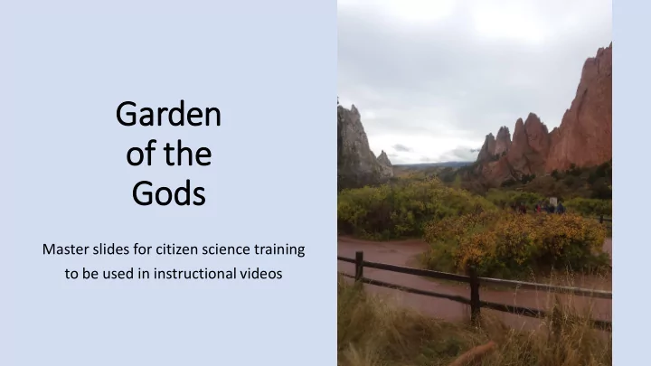
Garden of f th the Gods Master slides for citizen science - - PowerPoint PPT Presentation

garden of f th the gods
SMART_READER_LITE
LIVE PREVIEW

Garden of f th the Gods Master slides for citizen science - - PowerPoint PPT Presentation

Garden of f th the Gods Master slides for citizen science training to be used in instructional videos Garden of f th the Gods Garden of the Gods Park in Colorado Springs, CO owned by the City of Colorado Springs National Natural


slide-1
SLIDE 1

Garden

  • f

f th the Gods

Master slides for citizen science training to be used in instructional videos

slide-2
SLIDE 2

Garden of f th the Gods

Garden of the Gods Park in Colorado Springs, CO

  • owned by the City of

Colorado Springs

  • National Natural

Landmark

  • busiest city park in the

United States

slide-3
SLIDE 3

Rec ecreation Imp Impacts ts

In 2014, Garden of the Gods was awarded Trip Advisor’s Travelers’ Choice Award as the best park to visit in the United States.

1,300 acres x 0.0015 = 2.03 square miles for 2 million visitors/yr. Perspective: Rocky Mountain National Park is 265,761 acres (415.25 sq mi) for 3 million users/yr. What does this mean? The Garden of the Gods’ visitor density is 100 times greater than that of Rocky Mountain National Park.

slide-4
SLIDE 4

Most of the trails in the Garden were established in the 1930’s and were never designed to accommodate the current level of use. Many of the climbing access trails are straight lines up to the base of climbs, and do not consider the surrounding topography and effects of water.

Rec ecreation Imp Impacts ts

slide-5
SLIDE 5

The primary goals of RMFI’s Garden of the Gods Community Restoration Program are to:

  • Provide stewardship opportunities for a broad

spectrum of the community including individuals, local schools, community organizations, businesses, and religious institutions

  • Foster community awareness about the ecology and

natural history of the Garden of the Gods Park

  • Educate the community about the current threats to

the park

  • Complete critical restoration work in the most

severely degraded areas of the park.

Rec ecreation Imp Impacts ts

slide-6
SLIDE 6

Res estoratio ion Mon

  • nit

itorin ing Que uestio ions

  • How does the trail change over time?
  • How do slope and aspect relate to trail tread

depth and width?

  • Do structures slow the rate of change on a

trail? Is this correlated with slope and aspect?

slide-7
SLIDE 7

Rese esearch Obj bjectiv ives

  • Create a long-term monitoring data set that

records trail depth and width over time.

  • Analyze the effect of slope and aspect on trail

dynamics over time.

  • Compare depth and width before and after

structures are implemented.

slide-8
SLIDE 8

Data a Col

  • lle

lectio ion Obje bjectiv ives

  • Measure the trail tread depth and width over

time

  • Measure the slope and aspect of trail
  • Collect photo point data over time
slide-9
SLIDE 9

Lea earning Obje jectiv ives for Citiz itizen Sci cience e Trai aining Init Initia iativ ive

  • Explain how recreational impacts affect trails and their

environs

  • Describe the effects of erosion and identify erosion in

landscape photos

  • Identify flora and fauna present
  • Define slope and aspect and know how to measure it
  • Take tread depth and width measurements in the field

and record them in the datasheet

Barrel cactus (Ferocactus spp.)

slide-10
SLIDE 10

Landscape dynamics and erosion instruction

  • These slides will be used to develop instructional
slide-11
SLIDE 11

Slo lope

  • The angle of the land surface
  • Measured by ecologists
  • Effect of gravity on the movement of materials-

erosion

  • Recreational impact by trail users
  • The steeper the slope, the more materials

tend to movement downward rather than stay in place

  • Ex. Extent of erosion
  • Ex. Avalanche danger
slide-12
SLIDE 12

Aspe spect

  • The geographic direction towards

which the land surface faces

  • Causes variation in vegetation on

the land surface

  • Moisture
  • Solar radiation and therefore

temperature

  • In Colorado, due to the position of

the sun at this latitude (41°N)

  • south- and west-facing slopes are

similar (drier, warmer, shorter vegetation)

  • North- and east-facing slopes are

similar (wetter, colder, taller vegetation)

Can you see which aspect is north-facing based on the vegetation?

slide-13
SLIDE 13

Er Eros

  • sio

ion

  • How does erosion affect the landscape and how can you detect it?
  • http://jornada.nmsu.edu/files/RSQIS9.pdf
slide-14
SLIDE 14

Er Eros

  • sio

ion in in Gar arden of

  • f the

the God

  • ds
slide-15
SLIDE 15

Er Eros

  • sio

ion in in Gar arden of

  • f the

the God

  • ds
slide-16
SLIDE 16

Er Eros

  • sio

ion in n Gar arden of

  • f the

the God

  • ds
slide-17
SLIDE 17

Trail dynamics instruction

  • These slides will be used in the instructional video that trains citizen

scientists perform the trail dynamics and photo point measurement protocols

slide-18
SLIDE 18

Data a Col

  • lle

lectio ion Obje bjectiv ives

  • Measure the trail tread depth and

width over time

  • Measure the slope and aspect of

trail

  • Collect photo point data over

time

slide-19
SLIDE 19

Mon

  • nit

itorin ing In Informatio ion

  • Schedule: once per month and after

storm events

  • Location: Garden of the Gods
  • Equipment needed: camera, map of

photo points, trail map, 1 meter tape, 1 meter stick, compass, clinometer

  • Field notebook includes: Diagram of

measurements, brief explanation for measurement of aspect and slope, data collection sheet, photo point diagram

slide-20
SLIDE 20

Trail width: Using the meter stick if it is long enough, or the meter tape if necessary, measure the distance across the trail. Measure from the plant/soil interface on either side. Record in cm. Trail depth: Using the meter stick if it is long enough, or the meter tape if necessary, measure the depth from the center of the width measurement to the trial surface. Record in cm. Soil sample: collect a small sample in a baggie. Back in the lab, characterize the soil according to texture and material, if non-native (ie crusher fines, gravel). Slope and aspect: Using a clinometer, record the slope of the fall line and trail at the site of width/depth measurement. Use the compass to measure the aspect.

Take these measurements every 10 meters along the trail, starting at the permanent marker

slide-21
SLIDE 21

How to

  • mea

easure sl slope

  • Use a slope meter (clinometer)
  • Trail slope: rest the slope meter on the

ground right under the depth measurement site.

  • Fall line slope: rest the slope meter on

the meter stick used for the width measurement

  • on level ground
  • avoid setting it on a rock or other debris

in the trail that is not the trail surface

  • Record measurement on the data

sheet

slide-22
SLIDE 22

How to

  • mea

easure as aspect

  • Stand in the trail facing downhill
  • Hold the compass at your chest in your level

palm

  • You and the compass are one; the direction of

travel arrow should be pointing out from your chest in the direction of your line of site

  • Turn the dial under red fred (the compass

needle) is in the shed (the hollow arrow on the dial that moves with the compass dial)

  • Read the bearing at the direction of travel

arrow

  • Record measurement on the data sheet
slide-23
SLIDE 23

Pho hoto po poin ints

  • Photo points are permanently

established photos that show change

  • ver time
  • Taken at easily identifiable landscape

feature

  • Like trail junctions, specific trees, etc.
  • Photo points are not taken at every

trail measurement

  • They characterize the larger context
  • Each site has 3-5 photo points
  • Record the photo number from digital

camera in the data sheet

slide-24
SLIDE 24

Data a col

  • llectio

ion she sheet

  • Data can be collected
  • on paper data sheet
  • using smartphone and google sheets
slide-25
SLIDE 25

Vegetation Monitoring Instruction

  • The following slides will be used for the instructional video that trains

citizen scientists in plant identification, which will be pertinent if we resume measurement of established vegetation plots near Spring Canyon picnic area.

  • Additional slides not yet created will describe the measurement

protocol.

slide-26
SLIDE 26

Restoration mix nati tive pla lants

Bouteloua curtipendula sideoats grama Pascopyrum smithii western wheatgrass Bouteloua gracilis blue grama Schizachyrium scoparium little bluestem Festuca ovina sheep fescue Nassella viridula green needlegrass Panicum virgatum Switchgrass

slide-27
SLIDE 27

Flo Flora see seen in n the the Gar arden

Oxytropis locoweed Salvia sage Solanaceae nightshade

slide-28
SLIDE 28

Flo Flora see seen in n the the Gar arden

Bromus inermis smooth brome Ferocactus barrel cactus Opuntia prickly pear Castilleja Indian paintbrush Oryzopsis hymenoides Indian ricegrass Agropyron cristatum crested wheatgrass

slide-29
SLIDE 29

Ex Exot

  • tic

ic pla plants

Colorado Noxious Weed Law https://www.colorado.gov/pacific/sites/ default/files/Current%20Noxious%20W eed%20List_123015.pdf Tamarix pentandra saltcedar

slide-30
SLIDE 30

Ex Exot

  • tic

ic pla plants

Linaria dalmatica Dalmatian toadflax Circium vulgare Canada thistle Euphorbia esula leafy spurge Centaurea diffusa diffuse knapweed Convolvus arvensis field bindweed

slide-31
SLIDE 31

Conium maculatum poison hemlock Cardaria draba hoary cress Clematis orientalis

  • riental clematis

Toxicodendron rydbergii Poison ivy

Ex Exot

  • tic

ic pla plants

slide-32
SLIDE 32

Transect

  • A line along which measurements are taken
  • Can be random…in several ways
  • Can be systematic…in several ways
  • Where will it start?
  • Where will it end?
  • What will you measure along the transect?
  • How will you know when you have sampled enough?
slide-33
SLIDE 33

Qua uadrat

  • 1 meter square with cross lines so that

each square = 1cm2

  • There are lots of ways to interpret this

measurement schema

  • All protocols must be established prior to

measurement

  • Talk with your peers- come up with one

way to use the square to measure percent cover

  • Hint: you will have to decide what percent

cover means…among other considerations

slide-34
SLIDE 34

Qua uadrat

Let’s practice How many squares contain flowers? If you count presence/absence per square, what is the percent cover? If you estimate what percentage using each square as a frame of reference, what is the percent cover?