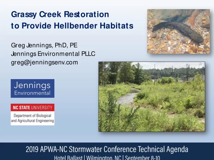
SLIDE 1
Grassy Creek Restoration to Provide Hellbender Habitats
Greg Jennings, PhD, PE Jennings Environmental PLLC greg@jenningsenv.com
SLIDE 2
Stream Restoration
Adjusting physical, biological, and chemical conditions to set the stream ecosystem on a trajectory toward improved ecological functions and services
Beeson Creek, Kernersville, NC
SLIDE 3 Stream Restoration Project Components
- Channel & floodplain morphology (Fluvial Geomorphology)
- In-stream structures (grade control, bank protection, bedform)
- Streambank bio-engineering
- Native riparian buffers
- Watershed management
UT Sentell Creek Dam Removal, Hendersonville, NC
SLIDE 4 Fluvial Geomorphology
- How are stream channels & floodplains shaped by flowing water?
- How to restore natural equilibrium to disturbed stream systems?
- How to manage flood flows and sediment transport?
UT Crabtree Creek, M orrisville, NC
SLIDE 5 Grassy Creek, Spruce Pine, NC: 2015
- Streambank erosion
- Lack of riparian buffer
- Incised, straightened channel (plane bed, poor habitats)
- Stormwater runoff from shopping center
SLIDE 6 Grassy Creek, Spruce Pine, NC
- French Broad River Basin, Blue Ridge Ecoregion 65
- 3,000 linear feet surrounded by commercial development
- Drainage area = 9.4 sq mi
SLIDE 7
Grassy Creek, Spruce Pine, NC: 2015
SLIDE 8 Eastern Hellbender (Cryptobranchus a. alleganiensis)
- Needs fast flow in order to absorb DO through skin
- Needs large flat shelter rocks, sand for nesting, deep pools, and
cobble riffles for young
- Needs food supply of crayfish
SLIDE 9
Eastern Hellbender (Cryptobranchus a. alleganiensis)
SLIDE 10 Grassy Creek Project Partners
T
Blue Ridge RC&D US Fish & Wildlife Service NC Clean Water Management Trust Fund NC Division of Water Resources NC Wildlife Resources Commission Design-Build Team:
- North State Environmental
- Jennings Environmental
- Zink Environmental
- Stantec
- Equinox
- Penrose Environmental
SLIDE 11
Project Objectives: 2015-2020
1. Improve water quality by reducing sediment & nutrients 2. Improve aquatic and terrestrial habitats 3. Provide educational opportunities for community 4. Connect Overmountain Victory Trail
SLIDE 12
Overmountain Victory Trail
Route of the Overmountain Men march to the Battle of Kings Mountain, October 7, 1780
SLIDE 13 Grassy Creek Restoration Timeline
- Survey, design, permitting in early 2015
- Construction and planting completed in early 2016
- Channel realignment, floodplain connection, riparian
planting, in-stream structures, stormwater wetlands
SLIDE 14 Grassy Creek Restoration Plan (as-built)
SF SF
SF S F S F
+ 2+00 4+00 6+00 8+00 1 + 1 2 + 14+00 1 6 + 1 8 + 20+00 2 2 + 24+00 2 6 + 28+00 30+00 31+89
EXISTING PIPE IN CONCRETE EXPOSED PIPE CROSSING EXPOSED PIPE CROSSING GRAVEL DRAINAGE DITCH 18'' CPP 18'' CPP 24'' CPP 18'' CPP 24'' CPP 48'' CMP TWO - 48'' CMP STREAM 1 - PERENNIAL 24'' CPP NON-FUNCTIONING STORMWATER BASIN BOULDER WALL ROCK ARMOR ROCK ARMOR STREAM 3 PERENNIAL PIPE CLEANOUT PIPE CLEANOUT LOW HANGING POWER LINE REACH 1: ENHANCE EXISTING BED FEATURES TO PROMOTE STABILITY AND HABITAT DIVERSITY ADD HABITAT ENHANCEMENT FEATURES REACH 2: ENHANCE EXISTING BED FEATURES TO PROMOTE STABILITY AND HABITAT DIVERSITY REACH 3: REALIGN CHANNEL AWAY FROM STEEP AND ERODING BANKS. ADJUST BED PROFILE TO MINIMIZE IMPACTS OF WATER AND SEWER CROSSINGS. INCORPORATE HABITAT ENHANCEMENT FEATURES. REACH 1:CHANNEL BED AND HABITAT ENHANCEMENT REACH 2: CHANNEL BED AND HABITAT ENHANCEMENT REACH 3: CHANNEL REALIGNMENT AND HABITAT ENHANCEMENT HWY 226 C A R T E R S R I D G E R D PRIVATE DRIVEWAY
XX
STREAM 2 PERENNIAL STREAM 4 INTERMITTENT WETLAND C WETLAND B WETLAND D STORMWATER TREATMENT SWALE
SLIDE 15 Upstream Reaches 1 & 2 (1,800 ft)
- Bank stabilization
- In-stream habitat structures
- Grade control at utility crossing
- Native riparian vegetation
SLIDE 16 J
STATION 2+00 meander bend streambank protection and scour pool maintenance
Before J anuary, 2016
SLIDE 17 August, 2016 August, 2019
J
STATION 2+00 meander bend streambank protection and scour pool maintenance
SLIDE 18
Bank Grading & Planting
STATION 8+00 to 18+00 streambank sloping with native woody plants
Before December, 2015
SLIDE 19
Bank Grading & Planting
STATION 8+00 to 18+00 streambank sloping with native woody plants
August, 2016 August, 2019
SLIDE 20
Boulder Cross Vane
STATION 14+00 grade control and streambank protection downstream of water line crossing
Before J anuary, 2016
SLIDE 21
Boulder Cross Vane
STATION 14+00 grade control and streambank protection downstream of water line crossing
August, 2016 August, 2019
SLIDE 22 Downstream Reach 3 (1,300 ft)
- Realign 900 ft channel away from parking lot
- Excavate floodplain to match bankfull elevation
- In-stream habitat structures
- Native riparian vegetation
SLIDE 23
Channel Relocation
STATION 18+00 to 27+00 meandering stream with habitat enhancements, floodplain, and native plants
Before November, 2015
SLIDE 24
Channel Relocation
STATION 18+00 to 27+00 meandering stream with habitat enhancements, floodplain, and native plants
November, 2015
Transferring bed substrate and fish from old channel to new
SLIDE 25
Channel Relocation
STATION 18+00 to 27+00 meandering stream with habitat enhancements, floodplain, and native plants
September, 2018 August, 2019
SLIDE 26
Toe Wood Revetment
STATION 25+00 streambank protection & meander pool enhancement
November, 2015 J anuary, 2016
SLIDE 27
August, 2016 August, 2019
Toe Wood Revetment
STATION 25+00 streambank protection & meander pool enhancement
SLIDE 28
Sewer Crossing
STATION 26+00 stream realignment for perpendicular crossing with bank protection
Before J anuary, 2016
SLIDE 29
Sewer Crossing
STATION 26+00 stream realignment for perpendicular crossing with bank protection
J uly, 2016 August, 2019
SLIDE 30
Habitat Structures
Flat boulders in glides tilted up on downstream end
M ay, 2016 August, 2019
SLIDE 31
Habitat Structures
Flat boulders in glides tilted up on downstream end
SLIDE 32
Habitat Structures
Log Vanes for bank protection and scour pools August, 2019
SLIDE 33
Constructed Stormwater Wetlands (CSWs)
SLIDE 34
Constructed Stormwater Wetlands (CSWs)
SLIDE 35 Vegetation
Native plants to replace invasives
eed (temp & perm)
SLIDE 36
Vegetation
Native plants to replace invasives
Live stakes: silky dogwood, silky willow, ninebark, elderberry
SLIDE 37 Education
T
Community access
SLIDE 38
- Morphology, Vegetation, Macroinvertebrates
- Hellbenders
M onitoring
SLIDE 39
- eDNA evidence of Hellbender in Spring, 2017
- Photographic evidence in Spring, 2017
- Live specimens in Spring, 2018
Hellbenders?
2018 2017
SLIDE 40
Hellbenders in 2018
SLIDE 41
- Urban constraints limit design &
construction
- Habitat focus (food chain):
- “Natural” rocks & logs
- Riffles, pools, glides, steps
- Fine roots
- Hyporheic connections
- Floodplain connection & riparian
vegetation critical
- Patience required for ecological
recovery
Lessons Learned