goodhue county bedrock geology relevance to silica sand
play

Goodhue County Bedrock Geology relevance to silica sand mining Tony - PowerPoint PPT Presentation

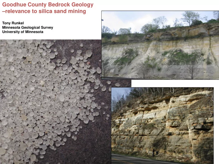
Goodhue County Bedrock Geology relevance to silica sand mining Tony Runkel Minnesota Geological Survey University of Minnesota The Goodhue County Geologic Atlas describes and shows the distribution of bedrock, loose sediment on top of


  1. Goodhue County Bedrock Geology – relevance to silica sand mining Tony Runkel Minnesota Geological Survey University of Minnesota

  2. The Goodhue County Geologic Atlas describes and shows the distribution of bedrock, loose sediment on top of bedrock, and water within the rock and SAND, GRAVEL, CLAY sediment BEDROCK BEDROCK VERSUS QUATERNARY SEDIMENT (unconsolidated sand/gravel/clay) Tony Runkel Minnesota Geological Survey University of Minnesota

  3. GOODHUE COUNTY BEDROCK MAP A’ A A’ A Tony Runkel Minnesota Geological Survey University of Minnesota

  4. Quartz- rich sand grains from bedrock (“silica sand”) Typical “glacial” sand on top of bedrock Tony Runkel Minnesota Geological Survey University of Minnesota

  5. A’ Quartz-rich bedrock layers generally near land surface Jordan Sandstone St Peter Sandstone Tony Runkel A Minnesota Geological Survey University of Minnesota A’ A Kenyon area White Rock area Red Wing area

  6. Example: Jordan Sandstone ~500ft Red Wing area Kenyon area White Rock area Tony Runkel Minnesota Geological Survey University of Minnesota

  7. Example: St Peter Sandstone ~500ft Kenyon area Red Wing area White Rock area Tony Runkel Minnesota Geological Survey University of Minnesota

  8. Quartz-rich bedrock layers generally near land surface Jordan Sandstone St Peter Sandstone Tony Runkel Minnesota Geological Survey University of Minnesota

  9. Thickness of unconsolidated (glacial” sediment in feet) = bedrock “cover” Tony Runkel Minnesota Geological Survey University of Minnesota

  10. Quartz-rich bedrock layers Covered by less than 50 ft unconsolidated sediment Jordan Sandstone St Peter Sandstone Tony Runkel Minnesota Geological Survey University of Minnesota

  11. Quartz-rich sandstone bedrock layers at or near (approx 50 ft) land surface St Peter at/near surface Jordan at/near surface Draft (unreviewed) Map by Minnesota Geological Survey Tony Runkel Tony Runkel Minnesota Geological Survey Minnesota Geological Survey University of Minnesota University of Minnesota

  12. Tony Runkel Minnesota Geological Survey University of Minnesota

  13. Tony Runkel Minnesota Geological Survey University of Minnesota

Download Presentation
Download Policy: The content available on the website is offered to you 'AS IS' for your personal information and use only. It cannot be commercialized, licensed, or distributed on other websites without prior consent from the author. To download a presentation, simply click this link. If you encounter any difficulties during the download process, it's possible that the publisher has removed the file from their server.

Recommend


More recommend