g eotechnical p roblems in the 2011 t ohoku p acific e
play

G EOTECHNICAL P ROBLEMS IN THE 2011 T OHOKU P ACIFIC E ARTHQUAKE - PDF document

JOINT CONFERENCE PROCEEDINGS ! 9th International Conference on Urban Earthquake Engineering/ 4th Asia Conference on Earthquake Engineering March 6-8, 2012, Tokyo Institute of Technology, Tokyo, Japan G EOTECHNICAL P ROBLEMS IN THE 2011 T OHOKU P


  1. JOINT CONFERENCE PROCEEDINGS ! 9th International Conference on Urban Earthquake Engineering/ 4th Asia Conference on Earthquake Engineering March 6-8, 2012, Tokyo Institute of Technology, Tokyo, Japan G EOTECHNICAL P ROBLEMS IN THE 2011 T OHOKU P ACIFIC E ARTHQUAKE Kohji Tokimatsu 1) , Shuji Tamura 2) , Hiroko Suzuki 3) and Kota Katsumata 4) 1) Professor, Dept. of Architecture and Building Engineering, Tokyo Institute of Technology, Japan 2) Associate Professor, Disaster Prevention Research Institute, Koto University, Japan 3) Assistant Professor, Dept. of Architecture and Building Engineering, Tokyo Institute of Technology, Japan 4) Graduate Student, Dept. of Architecture and Building Engineering, Tokyo Institute of Technology, Japan kohji@o.cc.titech.ac.jp Abstract: An overview of the geotechnical aspects of the building damage in the 2011 Tohoku Pacific earthquake is presented, based on field reconnaissance made after the quake. It is shown that: (1) Extensive soil liquefaction occurred along the coast of Tokyo Bay and around the Tonegawa River floodplain. Liquefaction primarily occurred within relatively new reclaimed area, with large ground settlement up to 60 cm, accompanied by settlement/tilting of wooden and reinforced concrete buildings supported on spread foundations; (2) Numerous houses in Sendai’s hilly residential areas constructed with cut-and fill methods were badly damaged not only by simple collapse of retaining walls, but also by slope failures of fill; (3) Several pile-supported buildings tilted and settled not only in the Tohoku region but also in the Kanto plain, implying damage to pile foundations; and (4) Within Onagawa and Rikuzen-Takata, several steel and reinforced concrete structures were knocked over by tsunami surges, probably after having suffered damage to their pile foundations. damage mainly in the Tohoku region, leaving about 20,000 1. INTRODUCTION people dead or missing. Furthermore, soil liquefaction and A massive earthquake shook northeastern Japan at 2:46 other ground disasters have left extensive damage to p.m. on March 11, 2011. At magnitude 9.0, the infrastructure, lifelines, houses and other structures. Tohoku-Pacific Ocean Earthquake, centering off the A group of researchers including these authors carried Sanriku coast, was the strongest jolt ever recorded in Japan. out a field survey starting on March 12 with a focus on The earthquake triggered giant tsunami, which caused huge geotechnical problems, damage on structure foundations and ground behaviors near K-NET strong motion stations. This paper reports on the results of the survey. But we must note that a survey by individual researchers can cover only a small portion of the vast stretches of land affected by the disaster. Furthermore, the survey on the reaches of the Tone River and on the Tohoku region was conducted after mid-March and early April, respectively. This paper, therefore, may not necessarily present the entire picture of the damage and that the findings were as of the time of the survey, which means aftershocks’ effects are included. 2. SOIL LIQUEFACTION DAMAGE IN TOKYO 
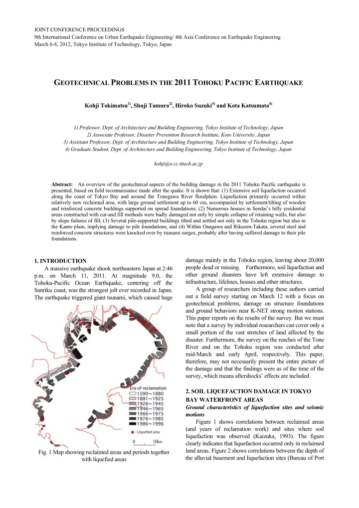
BAY WATERFRONT AREAS Ground characteristics of liquefaction sites and seismic motions Figure 1 shows correlations between reclaimed areas (and years of reclamation work) and sites where soil liquefaction was observed (Kaizuka, 1993). The figure clearly indicates that liquefaction occurred only in reclaimed land areas. Figure 2 shows correlations between the depth of Fig. 1 Map showing reclaimed areas and periods together the alluvial basement and liquefaction sites (Bureau of Port with liquefied areas

  2. and Harbor, Tokyo Metropolitan Government, 2001; Kanto liquefaction was observed near two stations: at K-NET Regional Development Bureau, Ministry of Land, Inage (CHB024) and K-NET Tatsumi (TKY017). No Infrastructure, Transportation and Tourism, 2011; Ministry liquefaction was spotted in the neighborhood of K-NET of Land, Infrastructure, Transportation and Tourism, 2011). Urayasu (CHB008), which is located north of the old It is interesting to note that most of the extensively liquefied coastline in Urayasu city. sites are located in areas where the basement depth is 35-40 The acceleration time history at K-NET Inage (a meters or more. duration of 100 seconds including principal motions) is shown in Figure 3. The peak acceleration was 2.34m/s 2 in Among the K-NET strong motion stations along the the north-south direction and 2.03m/s 2 in the east-west Tokyo Bay coast at which digitized time-history data of the main shock are available (National Research Institute for direction. Spiky waves occurring around 120 seconds Earth Science and Disaster Prevention, 2011), soil suggest a possibility of cyclic mobility of sand in a liquefaction process. Figure 4 shows the running spectrum at K-NET Inage, normalized at the spectral peak of each 10-second interval. The periods become elongated from 0.7 s to about 4 s between 110 seconds to 140 seconds. This suggests that the ground liquefied gradually with cyclic loading during the 30 seconds. Figures 5-6 present similar data for K-NET Urayasu, where no liquefaction occurred. Unlike that at K-NET Inage, the running spectrum at K-NET Urayasu shows no apparent changes in the spectral peak period. Considering the fact that the principal motion with accelerations greater than about 1 m/s 2 at the non-liquefied Urayasu site lasted about 30 s from 110 to 140 seconds, complete liquefaction at Inage likely to have occurred in the latter part of the principal motion. Soil liquefaction damage in Urayasu city Extensive soil liquefaction occurred in reclaimed area along the coast Tokyo Bay, including Shinkiba in Koto ward, Urayasu city, Ichikawa city, Funabashi city, Fig. 2 Map showing depth of alluvial deposit and liquefied area Fig. 3 Acceleration time histories at K-NET Inage Fig. 5 Acceleration time histories at K-NET Urayasu during the main shock ! ! ! ! ! ! ! ! ! ! during the main shock Fig. 4 Normalized running spectra at Inage Fig. 6 Normalized running spectra at Urayasu

  3. Narashino city, and Mihama ward in Chiba city. This section reports liquefaction damage in Urayasu city, Chiba Prefecture. Figure 7 shows a map of Urayasu city, Chiba Prefecture, which was covered by this survey, and the years when reclamation work was done for each area. The work in the area started in around 1964 outside levees along the old coastline. In the areas reclaimed in the first phase of the project through 1975, many houses, commercial buildings and public facilities have been built. Meanwhile, the areas completed in the second phase through 1980 have many high-rise condominium buildings, universities, hotels and storehouses. Vacant lots still dot areas near the coast. Sand excavated from the seabed off Urayasu was mainly used to fill the reclamation sites. In Urayasu city, a magnitude-6.7 Fig. 7 Map showing reclaimed period and investigated area quake that occurred off eastern Chiba Prefecture on Dec. 17, caused by the magnitude-9.0 earthquake. 1987 (Chibaken Toho-oki Earthquake), reportedly caused 2) In areas where liquefaction occurred, many sand boils, liquefaction in such areas as Kairaku 1-chome, Mihama ground settlements as well as settlements and tilts of 3-chome and Irifune 4-chome. building and houses on spread foundations (Photos 1-3) The authors’ group carried out a survey in the area were observed, and gaps were created between circled with the dotted line in Figure 7. In the survey area, pile-supported structures and surrounding ground (Photo 3), no liquefaction damage was observed northwest of the old causing damage to piping and other facilities. Underground coastline, including the neighborhood of Urayasu Station facilities, such as manholes, emergency water tanks and and K-NET Urayasu site. The survey made the following parking lots were uplifted (Photo 4), damage was done to findings that are common to the areas covered. tap water and sewerage systems, roads had dents and utility 1) In many areas where no liquefaction occurred, including poles were toppled. But little or no damage to the Tokyo Disneyland, ground improvement work of some superstructures induced by seismic force was observed. kind has been carried out. This has confirmed the Even where foundations settled or tilted, few upper effectiveness of ground improvement work against structures suffered damage as a result. That was because earthquake jolts with a peak ground acceleration of 2.0m/s 2 ���������� ���������� �� Photo 1 Large settlement of a building ������� Photo 3 Pile-supported building and settled building ����� Photo 2 Largely tilted building ����������� Photo 4 Uplift of underground parking lot

Download Presentation
Download Policy: The content available on the website is offered to you 'AS IS' for your personal information and use only. It cannot be commercialized, licensed, or distributed on other websites without prior consent from the author. To download a presentation, simply click this link. If you encounter any difficulties during the download process, it's possible that the publisher has removed the file from their server.

Recommend


More recommend