
SLIDE 1
Forecasting at the National Hurricane Center Tokyo, March 2014
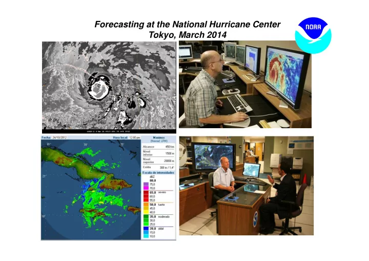
Forecasting at the National Hurricane Center Tokyo, March 2014 Lix, - - PowerPoint PPT Presentation
Forecasting at the National Hurricane Center Tokyo, March 2014 Lix, report to WMO National Hurricane Center Organizational Structure Hurricane Hurricane Tropical Technology Specialists Specialist Analysis and and Science Unit Unit
Forecasting at the National Hurricane Center Tokyo, March 2014
Lix, report to WMO
Hurricane Specialists Unit
Develop, coordinate (domestically and abroad), and issue tropical cyclone warnings, forecasts, and outlooks in text and graphical formats, mostly
Applied research and public awareness programs.
Tropical Analysis and Forecast Branch Technology and Science Branch
Marine/ocean and satellite analyses, forecasts and warnings in text and graphical formats, 24x7, (~100 products/day) Conduct tropical cyclone (Dvorak) analyses for the hurricane specialists Augments operational support staffing Computer systems support 24x7 Applications development and technology infusion Storm surge guidance (real time; community planning; preparedness) Emergency operational support staffing Develop, coordinate (domestically and abroad), and issue tropical cyclone warnings, forecasts, and
graphical formats (~700 full advisory packages/yr) “Off-season” outreach and public awareness programs Applied research
Hurricane Specialist Unit
Organizational Structure
2010
2 vacancies -> 1 vacancy -> 3 vacancies
(third begins in April)
}
SCEP
<- vacant
National Hurricane Center National Weather Service M iami Forecast Office National Hurricane Center National Weather Service M iami Forecast Office
reinforced with 45 miles of steel reinforcing rods
reinforced with 45 miles of steel reinforcing rods
1955: Regularly scheduled numerical model forecasts began 1961: 2-day tropical cyclone forecasts introduced 1964: 3-day tropical cyclone forecasts began 1980: NHC begins issuing all Atlantic advisories 1988: NHC assumes responsibility for the E. Pacific mid 1990s: NHC web site developed and graphics produced 2001: Cone graphic introduced 2003: 4-day and 5-day forecasts began 2007: Graphical Tropical Weather Outlook first issued 2010: Tropical cyclone watch/warning lead times increased 2013: Tropical Weather Outlook expanded from 48 h to 5 days
NHC Operations NHC Operations TAFB Operations TAFB Operations WFO Operations WFO Operations FEM A Operations FEM A Operations CARCAH (Reconnaissance) Operations CARCAH (Reconnaissance) Operations
Hurricane Liaison Team M edia Interviews
WORLD METEOROLOGICAL ORGANIZATION Regional Association IV (RA-IV) Coordination
RSMC= Regional Specialized Meteorological Center; RA-IV countries include Caribbean area, Central America, Mexico, Canada, and Bermuda.
issuing watches/ warning for their respective country or jurisdiction – NHC issues watches/ warnings for
Haiti
placement of watches/ warnings
Offices throughout the region
Watches and Warnings are currently not issued prior to the formation of a tropical depression
Hurricane Dean watches and warnings
W O R L D M E T E O R O L O G I C A L O R G A N I ZA T I O N T E C H N I C A L D O C U M E N T
TROPICAL CYCLONE PROGRAMME Report No. TCP-30 Regional Association IV (North and Central America and the Caribbean) Hurricane Operational Plan) 2013 Edition SECRETARIAT OF THE WORLD METEOROLOGICAL ORGANIZATION – GENEVA SWITZERLAND World Meteorological Organization 2013
L-0311 at Nat. Hurr. Conference State L-0320 Course
Plus two National Weather Service Training Courses in 2014!
“Battle is won (or lost) during the off-season…”
Highlights of annual NHC involvement with federal partners and Caribbean countries:
international meteorologists (2-week course at NHC)
evacuation decision making training courses
“Battle is won (or lost) during the off-season…”
Highlights of annual NHC involvement with federal partners and Caribbean countries:
international meteorologists (2-week course at NHC)
evacuation decision making training courses
among countries
watches and warnings to 30 WMO member nations
government meteorologists.
WMO RA-IV Hurricane Committee. Annual meeting updates the Region’s “Hurricane Operational Plan”
Awareness Tour
NHC provides the “big picture” that complements and guides local NWS forecast office products, and provides guidance for international partners
Plain-language text product
read”.
forecast
tornadoes, and generalized timing of wind arrival
information
are in effect
defined center within NWS radar range
warnings
advisories
data
software
pressure, and eye diameter
wind radii
probabilities of tropical-storm- force, 50 kt, and hurricane-force winds.
individual time period onset probabilities for a fixed set of locations
Wind Speed Probabilities
forecasts and warnings
and the forecast uncertainties
intensity forecasts
Track Forecast/ Cone Graphic – Five Day
Track Forecast/ Cone Graphic – Three Day
Shows:
watches & warnings
Shows:
affected so far by sustained winds of tropical storm force (in orange) and hurricane force (in red).
TROPICAL STORM CLAUDETTE TROPICAL CYCLONE UPDATE NWS TPC/NATIONAL HURRICANE CENTER MIAMI FL AL042009 1215 PM EDT SUN AUG 16 2009 ...DEPRESSION BECOMES TROPICAL STORM CLAUDETTE... DATA FROM THE NOAA DOPPLER RADAR IN TALLAHASSEE FLORIDA INDICATE THAT SURFACE WINDS ASSOCIATED WITH THE DEPRESSION HAVE INCREASED TO 40 MPH...65 KM/HR...MAKING THE DEPRESSION TROPICAL STORM CLAUDETTE.
....SUMMARY OF 1215 PM AST INFORMATION... LOCATION...28.7N 84.6W MAXIMUM SUSTAINED WINDS...40 MPH PRESENT MOVEMENT...NORTHWEST OR 320 DEGREES AT 14 MPH MINIMUM CENTRAL PRESSURE...1011 MB
$$ FORECASTER ROBERTS/BRENNAN
This product is issued when: (1) cyclone makes landfall (2) unexpected changes occur in the cyclone (3) to issue international watches and warnings (4) for 1-hourly position estimates when system with eye is nearing land
ABNT30 KNHC 011156 TWSAT MONTHLY TROPICAL WEATHER SUMMARY NWS TPC/NATIONAL HURRICANE CENTER MIAMI FL 800 AM EDT FRI OCT 01 2010 FOR THE NORTH ATLANTIC...CARIBBEAN SEA AND THE GULF OF MEXICO... EIGHT TROPICAL STORMS FORMED IN THE ATLANTIC BASIN DURING THE MONTH OF SEPTEMBER. THREE OF THESE STORMS...IGOR...JULIA...AND KARL... BECAME MAJOR HURRICANES...AND LISA REACHED HURRICANE STATUS. THESE NUMBERS ARE WELL ABOVE THE LONG-TERM (1944-2009) AVERAGES OF 4 TROPICAL STORMS...2 HURRICANES...AND ABOUT 1 MAJOR HURRICANE FOR THE MONTH OF SEPTEMBER. ALSO...THE FORMATION OF EIGHT NAMED STORMS TIES 2002 FOR THE RECORD NUMBER OF NAMED STORMS FORMING IN THE MONTH OF SEPTEMBER. IN TERMS OF ACCUMULATED CYCLONE ENERGY... ACE...WHICH MEASURES THE COMBINED STRENGTH AND DURATION OF TROPICAL STORMS AND HURRICANES...TROPICAL CYCLONE ACTIVITY IN SEPTEMBER WAS ABOUT 78 PERCENT ABOVE AVERAGE. SO FAR THIS SEASON...OVERALL TROPICAL CYCLONE ACTIVITY TO DATE IS ABOUT 53 PERCENT ABOVE THE LONG-TERM MEDIAN. REPORTS ON INDIVIDUAL CYCLONES...WHEN COMPLETED...ARE AT THE WEB SITE OF THE NATIONAL HURRICANE CENTER...USE LOWER-CASE LETTERS...HTTP://WWW.NHC.NOAA.GOV/2010ATLAN.SHTML SUMMARY TABLE NAME DATES MAX WIND (MPH)
TD TWO 7-8 JUL 35 TS BONNIE 22-24 JUL 40 TS COLIN 2-8 AUG 60 TD FIVE 10-11 AUG 35 MH DANIELLE 21-31 AUG 135 MH EARL 25 AUG-5 SEP 145 TS FIONA 30 AUG-4 SEP 60 TS GASTON 1-2 SEP 40 TS HERMINE 6-8 SEP 65 MH IGOR 8-21 SEP 155 MH JULIA 12-20 SEP 135 MH KARL 14-18 SEP 120 H LISA 21-26 SEP 80
month from J uly-Dec
that occurred during the previous month
website around the 1st of each month
tracks of the season’s tropical cyclones to date
intensities shown until final “best- track” issued
weeks to a couple of months after each storm
intensity, and size information
casualties, and provides forecast critique
– Changes to the 48-hour Graphical Outlook
Probability Table
available
Outlook and Tropical Cyclone Discussion
pertaining to tropical cyclone formation
potential for formation (into a tropical cyclone) during the next 5 days
Issued at 2 AM , 8 AM , 2 PM , 8 PM EDT During EST issuance times become- 1 AM , 7 AM , 1 PM , 7 PM
the first 48 hours and entire 5-day period are provided
P r
y p e
N e w 48 h
r G T WO
N e w 5
a y G T WO
P r e v i
s G r a p h i ca l O u t l
Corresponding text provided as mouse-over
Necessary but not sufficient conditions
MADDEN-JULIAN OSCILLATION: RELATED TO INTRASEASONAL VARIABILITY IN TC ACTIVITY?
200 MB VELOCITY POTENTIAL 5°N-5°S 5- DAY RUNNING MEAN
ACTIVE PERIOD IN ATLANTIC BASIN
realistically
models has a low false alarm rate
disturbances of non-tropical origin
latter guidance often is more consistent and can help resolve run to run changes of the former
to a model’s performance in one season will have to reacquaint himself/herself with the new model each season
and moisture has shown some promise for anticipating TC formation.
– No closed isobars – No organized cloud pattern (unclassifiable by the Dvorak Technique)
– Low pressure persists through forecast period – Reasonable spatial and temporal scale – At least one closed isobar (at 4 mb interval) with lowered central pressure – Reasonable structure (warm core, deep vertical extent) – NHC issued advisories (verification)
systematic verification is needed
seem to do better when large-scale influences are the dominant mechanism (e.g. monsoonal flow near western Africa)
forecasts
since models have difficulty depicting genesis in that region (smaller-scale processes play a bigger role?)
systematic verification is needed
seem to do better when large-scale influences are the dominant mechanism (e.g. monsoonal flow near western Africa)
forecasts
since models have difficulty depicting genesis in that region (smaller-scale processes play a bigger role?)
57
TROPICAL WEATHER OUTLOOK NWS NATIONAL HURRICANE CENTER MIAMI FL 200 AM EDT FRI SEP 6 2013 FOR THE NORTH ATLANTIC...CARIBBEAN SEA AND THE GULF OF MEXICO... THE NATIONAL HURRICANE CENTER HAS ISSUED THE LAST ADVISORY ON TROPICAL DEPRESSION GABRIELLE WHICH DISSIPATED NEAR THE DOMINICAN REPUBLIC.
LITTLE LESS THAN A HUNDRED MILES EAST OF TAMPICO IS MOVING
AREA OF CLOUDINESS AND A FEW SQUALLS. ALTHOUGH THE SYSTEM IS ALREADY APPROACHING LAND...A TROPICAL DEPRESSION COULD FORM BEFORE THE LOW MOVES INLAND ALONG THE COAST OF MEXICO LATER THIS MORNING. THIS SYSTEM HAS A MEDIUM CHANCE...50 PERCENT...OF BECOMING A TROPICAL CYCLONE DURING THE NEXT 48 HOURS...AND A MEDIUM CHANCE...50 PERCENT...OF BECOMING A TROPICAL CYCLONE DURING THE NEXT 5 DAYS. REGARDLESS OF TROPICAL CYCLONE FORMATION...HEAVY RAIN AND GUSTY WINDS WILL BE SPREADING ALONG THE COAST OF THE MEXICAN STATES OF VERACRUZ AND TAMAULIPAS TODAY. FORECASTER AVILA
Another formation near the coast (TS Fernand)
August 24 800 PM A LOW PRESSURE AREA ASSOCIATED WITH A TROPICAL WAVE LOCATED OVER THE WESTERN YUCATAN PENINSULA IS ACCOMPANIED BY A LARGE AREA OF CLOUDINESS AND THUNDERSTORMS. THIS DISTURBANCE IS FORECAST TO MOVE TOWARD THE WEST-NORTHWEST TONIGHT AND SUNDAY ACROSS THE SOUTHERN BAY OF CAMPECHE...WHERE ENVIRONMENTAL CONDITIONS APPEAR TO BE FAVORABLE FOR SOME DEVELOPMENT. THIS SYSTEM HAS A MEDIUM CHANCE...50 PERCENT...OF BECOMING A TROPICAL CYCLONE DURING THE NEXT 48 HOURS...AND A MEDIUM CHANCE...50 PERCENT...OF BECOMING A TROPICAL CYCLONE DURING THE NEXT 5 DAYS. AN AIR FORCE PLANE IS SCHEDULED TO INVESTIGATE THE SYSTEM ON SUNDAY AFTERNOON...IF
DISTURBANCE IS LIKELY TO MOVE INLAND OVER THE STATE OF VERACRUZ MEXICO IN A COUPLE OF DAYS.
TROPICAL WEATHER OUTLOOK NWS NATIONAL HURRICANE CENTER MIAMI FL 800 PM EDT SUN SEP 2 2012 FOR THE NORTH ATLANTIC...CARIBBEAN SEA AND THE GULF OF MEXICO... A SMALL LOW PRESSURE AREA LOCATED ABOUT 1150 MILES NORTHWEST OF THE CAPE VERDE ISLANDS IS PRODUCING DISORGANIZED SHOWERS AND
UNFAVORABLE FOR SIGNIFICANT DEVELOPMENT...AND THIS SYSTEM HAS A LOW CHANCE...10 PERCENT...OF BECOMING A TROPICAL CYCLONE DURING THE NEXT 48 HOURS. ELSEWHERE...TROPICAL CYCLONE FORMATION IS NOT EXPECTED DURING THE NEXT 48 HOURS. $$ FORECASTER PASCH
Genesis of small systems
ZCZC MIATWOEP ALL TTAA00 KNHC DDHHMM TROPICAL WEATHER OUTLOOK NWS NATIONAL HURRICANE CENTER MIAMI FL 1100 AM PDT SAT SEP 7 2013 FOR THE EASTERN NORTH PACIFIC...EAST OF 140 DEGREES WEST LONGITUDE.. THE NATIONAL HURRICANE CENTER IS ISSUING ADVISORIES ON TROPICAL DEPRESSION LORENA...WHICH IS LOCATED JUST WEST OF THE SOUTHERN BAJA CALIFORNIA PENINSULA. TROPICAL CYCLONE FORMATION IS NOT EXPECTED DURING THE NEXT 48 HOURS. OTHER SYSTEMS WITH FORMATION POTENTIAL BEYOND 48 HOURS... A LOW PRESSURE AREA IS EXPECTED TO FORM SOUTH OF THE COAST OF MEXICO EARLY NEXT WEEK...AND CONDITIONS APPEAR CONDUCIVE FOR SOME
BECOMING A TROPICAL CYCLONE DURING THE NEXT 48 HOURS AND A LOW CHANCE...20 PERCENT...OF BECOMING A TROPICAL CYCLONE DURING THE NEXT FIVE DAYS. && FIVE-DAY FORMATION PROBABILITIES ARE EXPERIMENTAL IN 2013. COMMENTS ON THE EXPERIMENTAL FORECASTS CAN BE PROVIDED AT... HTTP://WWW.NWS.NOAA.GOV/SURVEY/NWS-SURVEY.PHP?CODE=ETWO $$ FORECASTER BEVEN NNNN
TROPICAL WEATHER OUTLOOK NWS NATIONAL HURRICANE CENTER MIAMI FL 1100 AM PDT WED SEP 11 2013 FOR THE EASTERN NORTH PACIFIC...EAST OF 140 DEGREES WEST LONGITUDE. A BROAD AREA OF LOW PRESSURE HAS FORMED JUST SOUTH OF THE GULF OF
THUNDERSTORMS AND IS FORECAST TO MOVE LITTLE DURING THE NEXT FEW
A TROPICAL CYCLONE DURING THE NEXT 48 HOURS...AND A LOW CHANCE...20 PERCENT...OF BECOMING A TROPICAL CYCLONE DURING THE NEXT 5 DAYS. REGARDLESS OF DEVELOPMENT...THIS SYSTEM IN COMBINATION WITH ANOTHER DISTURBANCE EXPECTED TO BE IN THE BAY OF CAMPECHE...WILL BRING HEAVY RAINS TO PORTIONS OF EASTERN MEXICO FOR THE NEXT SEVERAL DAYS. FIVE-DAY FORMATION PROBABILITIES ARE EXPERIMENTAL IN 2013. COMMENTS ON THE EXPERIMENTAL FORECASTS CAN BE PROVIDED AT... HTTP://WWW.NWS.NOAA.GOV/SURVEY/NWS-SURVEY.PHP?CODE=ETWO FORECASTER AVILA
TROPICAL WEATHER OUTLOOK NWS NATIONAL HURRICANE CENTER MIAMI FL 500 PM PDT WED SEP 11 2013 FOR THE EASTERN NORTH PACIFIC...EAST OF 140 DEGREES WEST LONGITUDE..
TEHUANTEPEC IS PRODUCING A LARGE AREA OF DISORGANIZED SHOWERS AND
LAND ARE EXPECTED TO INHIBIT SIGNIFICANT DEVELOPMENT DURING THE NEXT FEW DAYS WHILE THIS DISTURBANCE DRIFTS NORTHWARD TOWARD THE COAST OF SOUTHERN MEXICO. THIS SYSTEM HAS A LOW CHANCE...10 PERCENT...OF BECOMING A TROPICAL CYCLONE DURING THE NEXT 48 HOURS...AND A LOW CHANCE...20 PERCENT...OF BECOMING A TROPICAL CYCLONE DURING THE NEXT 5 DAYS. REGARDLESS OF DEVELOPMENT...THIS SYSTEM IN COMBINATION WITH ANOTHER DISTURBANCE EXPECTED TO BE IN THE BAY OF CAMPECHE...WILL BRING HEAVY RAINS TO PORTIONS OF EASTERN MEXICO FOR THE NEXT SEVERAL DAYS. THESE RAINS COULD CAUSE LIFE-THREATENING FLASH FLOODS AND MUD SLIDES. FIVE-DAY FORMATION PROBABILITIES ARE EXPERIMENTAL IN 2013. COMMENTS ON THE EXPERIMENTAL FORECASTS CAN BE PROVIDED AT... HTTP://WWW.NWS.NOAA.GOV/SURVEY/NWS-SURVEY.PHP?CODE=ETWO FORECASTER BROWN
AN AREA OF LOW PRESSURE IS EXPECTED TO FORM ACROSS THE NORTHWESTERN CARIBBEAN SEA OR THE SOUTHERN GULF OF MEXICO BY THURSDAY OR FRIDAY...AND ENVIRONMENTAL CONDITIONS ARE FORECAST TO BECOME SOMEWHAT CONDUCIVE FOR DEVELOPMENT DURING THAT TIME. THIS SYSTEM HAS A LOW CHANCE...NEAR 0 PERCENT...OF BECOMING A TROPICAL CYCLONE DURING THE NEXT 48 HOURS...AND A LOW CHANCE...20 PERCENT...OF BECOMING A TROPICAL CYCLONE DURING THE NEXT 5 DAYS.
GFS 126-h forecast valid at 00Z 17 August 2013 850-mb relative vorticity and wind and MSLP
CLOUDINESS AND SHOWERS EXTENDING FROM THE SOUTHWESTERN CARIBBEAN SEA NORTHEASTWARD ACROSS MOST OF THE CENTRAL CARIBBEAN TO NEAR HISPANIOLA ARE ASSOCIATED WITH A TROPICAL WAVE AND A BROAD AREA OF LOW PRESSURE INTERACTING WITH AN UPPER- LEVEL TROUGH. ENVIRONMENTAL CONDITIONS ARE FORECAST TO GRADUALLY BECOME MORE CONDUCIVE FOR DEVELOPMENT OVER THE NEXT SEVERAL DAYS AS THE LARGE DISTURBANCE MOVES TOWARD THE YUCATAN PENINSULA AND THE SOUTHERN GULF OF MEXICO. THIS SYSTEM HAS A LOW CHANCE...NEAR 10 PERCENT...OF BECOMING A TROPICAL CYCLONE DURING THE NEXT 48 HOURS...AND A MEDIUM CHANCE...30 PERCENT...OF BECOMING A TROPICAL CYCLONE DURING THE NEXT 5 DAYS.
GFS 102-h forecast valid at 00Z 17 August 2013 850-mb relative vorticity and wind and MSLP
A TROPICAL WAVE OVER THE WESTERN CARIBBEAN SEA IS PRODUCING A LARGE AREA OF CLOUDINESS... SHOWERS...AND A FEW THUNDERSTORMS EXTENDING FROM CENTRAL AMERICA NORTHEASTWARD TO JAMAICA AND EASTERN CUBA. UPPER-LEVEL WINDS HAVE BECOME MORE FAVORABLE...AND SOME DEVELOPMENT OF THIS DISTURBANCE IS POSSIBLE OVER THE NEXT COUPLE OF DAYS AS IT MOVES NORTHWESTWARD AT 10 TO 15 MPH TOWARD THE YUCATAN PENINSULA AND SOUTHERN GULF OF
MORE MARGINAL FOR DEVELOPMENT WHILE THE SYSTEM IS OVER THE GULF OF MEXICO LATER THIS WEEK. THIS SYSTEM HAS A MEDIUM CHANCE... 30 PERCENT...OF BECOMING A TROPICAL CYCLONE DURING THE NEXT 48 HOURS...AND A MEDIUM CHANCE...40 PERCENT...OF BECOMING A TROPICAL CYCLONE DURING THE NEXT 5 DAYS.
GFS 84-h forecast valid at 06Z 17 August 2013 850-mb relative vorticity and wind and MSLP
THE LOW PRESSURE SYSTEM IN THE NORTHWESTERN CARIBBEAN SEA IS MOVING TOWARD THE WEST-NORTHWEST AT 10 MPH...AND IS PRODUCING WIND GUSTS TO GALE FORCE IN SQUALLS TO THE EAST OF THE CENTER. ASSOCIATED SHOWER AND THUNDERSTORM ACTIVITY CONTINUES TO SHOW SIGNS OF ORGANIZATION...AND A TROPICAL DEPRESSION COULD FORM BEFORE THE DISTURBANCE REACHES THE YUCATAN PENINSULA ON
INTO THE SOUTHERN GULF OF MEXICO...WHERE UPPER- LEVEL WINDS COULD BECOME A LITTLE LESS FAVORABLE FOR DEVELOPMENT. THIS SYSTEM HAS A HIGH CHANCE...70 PERCENT...OF BECOMING A TROPICAL CYCLONE DURING THE NEXT 48 HOURS...AND A HIGH CHANCE...80 PERCENT...OF BECOMING A TROPICAL CYCLONE DURING THE NEXT 5 DAYS. REGARDLESS OF WHETHER OR NOT A TROPICAL CYCLONE FORMS...HEAVY RAINS AND GUSTY WINDS ARE FORECAST TO SPREAD OVER THE YUCATAN PENINSULA...WESTERN CUBA...AND BELIZE DURING THE NEXT DAY OR TWO...AND INTERESTS IN THESE AREAS SHOULD MONITOR THE PROGRESS OF THIS DISTURBANCE.
GFS 78-h forecast valid at 00Z 18 August 2013 850-mb relative vorticity and wind and MSLP
GFS 126-h forecast valid at 00Z 2 September 2013 850-mb relative vorticity and wind and MSLP
A TROPICAL WAVE OVER WEST AFRICA IS EXPECTED TO MOVE OVER THE FAR EASTERN ATLANTIC IN ABOUT THREE DAYS. SOME DEVELOPMENT IS POSSIBLE AFTER THAT TIME WHILE THE SYSTEM MOVES WEST- NORTHWESTWARD AT 10 TO 15 MPH. THIS SYSTEM HAS A LOW CHANCE...NEAR 0 PERCENT...OF BECOMING A TROPICAL CYCLONE DURING THE NEXT 48 HOURS...AND A LOW CHANCE...20 PERCENT...OF BECOMING A TROPICAL CYCLONE DURING THE NEXT 5 DAYS.
At genesis Sandy had winds of 30 kt and a central pressure of 1002 mb F168 F156 F144 F132 F120 F108 F96 F84 F72 F60 F48 F36 F24 F12 F00
73
Karen – GFS Forecasts Valid 06Z 3 October 2013
At genesis, Karen had winds of 45 kt and a central pressure of 1006 mb
http://www.ssd.noaa.gov/PS/TROP/TCFP/atlantic.html
TIME SERIES OF TC GENESIS PARAMETERS -- 2012
Sandy: forecasts from 2012102012 (24h prior to genesis) -- Hit
ECMWF, GFS, NOGAPS, and UKMET genesis forecasts from 2004-2011. Full methodology and results available in Halperin et al. (2013), in revision.
for genesis forecasts from CMC, GFS, and NOGAPS at moe.met.fsu.edu/modelgen
model forecast genesis (see right).
5° lat/lon of forecast genesis time and location.
products planned to run in real- time during 2013 hurricane season.
15.5° N, 48° W on Aug 21 00Z. There is a 33% probability that genesis occurs between 10.5- 20.5° N and 43-53° W between Aug 20 00Z and Aug 22 00Z, based on 246 historical GFS forecast cases.
M edium-Range Genesis Forecasts
experimented with medium range genesis forecasts (0-5 and 3-5 day forecasts)
day genesis product is slated for release during the 2013 season
Classification Rapid intensification Guidance disagreement Hurricane Michael Hurricane Leslie
Michael Sandy
Genesis on the coast Rapid intensification near the coast (Raymond)
Communications
Vertical Structure Track Guidance ( Manuel)
ZCZC MIATCDAT5 ALL TTAA00 KNHC DDHHMM TROPICAL STORM ERNESTO DISCUSSION NUMBER 12 NWS NATIONAL HURRICANE CENTER MIAMI FL AL052012 1100 AM AST SAT AUG 04 2012 DESPITE THE EXCELLENT PRESENTATION ON SATELLITE WITH CYCLONICALLY CURVED CONVECTIVE BANDS AND A WELL ESTABLISHED UPPER-LEVEL OUTFLOW...DATA FROM A RECONNAISSANCE PLANE INDICATE THAT ERNESTO HAS NOT BECOME ANY BETTER ORGANIZED. IN FACT...THE WINDS HAVE DECREASED TO 45 KT AND THE PRESSURE HAS RISEN TO 1008 MB. I DO NOT HAVE ANY REASONS FOR THE CURRENT WEAKENING BUT I HAVE NO REASON TO FORECAST ADDITIONAL WEAKENING EITHER. THE SHEAR IS ANTICIPATED TO REMAIN LOW ACROSS THE CARIBBEAN...AND ERNESTO WILL MOVE OVER AN OCEAN WITH HIGHER HEAT CONTENT. GIVEN SUCH CONDITIONS...THE OFFICIAL FORECAST CALLS FOR ERNESTO TO BECOME A HURRICANE IN THE WESTERN CARIBBEAN. THIS FORECAST IS UNCERTAIN SINCE MODELS ARE IN DISAGREEMENT. SHIPS...LGEM AND THE GFDL FORECAST ERNESTO TO BECOME A HURRICANE WHILE THE HWRF EITHER FORECASTS NO CHANGE OR WEAKENING. FORECAST POSITIONS AND MAX WINDS INIT 04/1500Z 14.4N 68.7W 45 KT 50 MPH 12H 05/0000Z 14.8N 71.2W 45 KT 50 MPH 24H 05/1200Z 15.5N 74.5W 50 KT 60 MPH 36H 06/0000Z 15.7N 77.5W 65 KT 75 MPH 48H 06/1200Z 16.5N 80.5W 70 KT 80 MPH 72H 07/1200Z 18.0N 84.0W 80 KT 90 MPH 96H 08/1200Z 19.5N 87.0W 70 KT 80 MPH 120H 09/1200Z 22.0N 90.5W 60 KT 70 MPH $$ FORECASTER AVILA Thanks to AF Hurricane Hunter Plane
Structure
sfc
mid-lvl
Karen
85
86