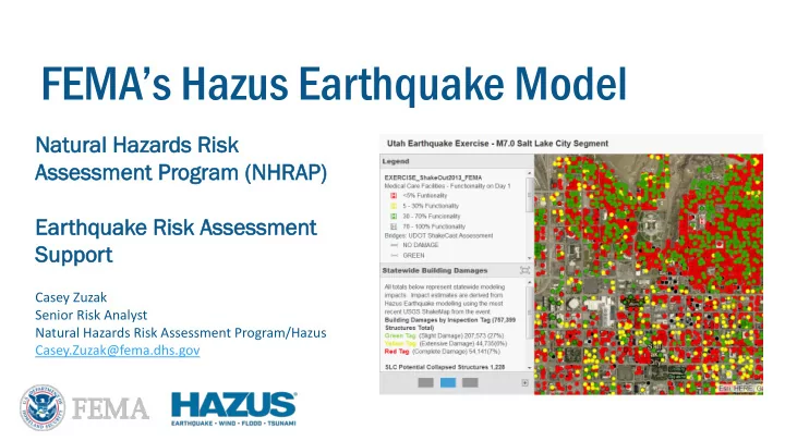
FEMA s Hazus Earthquake Model Na Natural tural Ha Hazar ards ds - - PowerPoint PPT Presentation

fema s hazus earthquake model
SMART_READER_LITE
LIVE PREVIEW

FEMA s Hazus Earthquake Model Na Natural tural Ha Hazar ards ds - - PowerPoint PPT Presentation

FEMA s Hazus Earthquake Model Na Natural tural Ha Hazar ards ds Ri Risk sk As Assessment sessment Pr Program ogram (N (NHRAP HRAP) Earthq Ea thquak uake e Ri Risk sk As Assessment sessment Su Suppor pport t Casey


slide-1
SLIDE 1

Na Natural tural Ha Hazar ards ds Ri Risk sk As Assessment sessment Pr Program

  • gram (N

(NHRAP HRAP) Ea Earthq thquak uake e Ri Risk sk As Assessment sessment Su Suppor pport t

FEMA’s Hazus Earthquake Model

Casey Zuzak Senior Risk Analyst Natural Hazards Risk Assessment Program/Hazus Casey.Zuzak@fema.dhs.gov

slide-2
SLIDE 2
  • Natural Hazards Risk Assessment Program
  • Hazus Earthquake Model Enhancements
  • Catastrophic Events Scenario Planning
  • NHRAP Liaison Role for Real Response Events
  • FEMA/USGS NEIC TwoPager Product

FEMA NHRAP/Hazus Earthquake Risk Assessment Support

NHRAP/Hazus EQ

slide-3
SLIDE 3
  • Newly created program under the FEMA HQ Risk Management Directorate in 2017
  • Goal: Provide risk assessment data, tools, analyses, and methodological guidance

to support FEMA programs and partners in the development of risk communication for all phases of emergency management.

  • NHRAP closely coordinates EQ risk assessment efforts with the USGS National

Earthquake Information Center (NEIC)

  • FEMA’s Hazus Program is now managed by the Natural Hazards Risk Assessment

Program

  • Program Manager: Jesse Rozelle
  • Senior Risk Analyst: Casey Zuzak

Natural Hazards Risk Assessment Program

NHRAP/Hazus EQ

slide-4
SLIDE 4
  • Hazus is FEMA’s natural hazards loss estimation tool for earthquakes,

floods, hurricane winds, and tsunamis

  • Hazus was first released in 1997 to standardize loss estimation

methodology in the federal government

  • It has an open and transparent methodology, vetted by the scientific

community, and made freely available to the public

  • Hazus has been highlighted by the World Bank and the European

Union as one of the leading loss estimation models in the world

  • Used extensively for Utah Wasatch Front Catastrophic Planning

Hazus Earthquake Loss Estimation Model Overview

NHRAP/Hazus EQ

slide-5
SLIDE 5

Hazus Model Supported Hazards

Earthquake Hurricane Wind & Storm Surge Riverine & Coastal Flooding Tsunami (near & distant source)

NHRAP/Hazus EQ

slide-6
SLIDE 6

Hazus Model Development Timeline

slide-7
SLIDE 7

A check mark indicates the hazard module performs some type of analysis (produces output) for that loss or damage category; that analysis should not be assumed to be the same as other hazards checked for the same category, nor should it be assumed to be comprehensive.

slide-8
SLIDE 8

Hazus Spectrum Method for Buildings Damages

NHRAP/Hazus EQ

slide-9
SLIDE 9

Construction Type Specific Collapse Rates

NHRAP/Hazus EQ

slide-10
SLIDE 10

Probability Estimation of Casualty Levels

NHRAP/Hazus EQ

slide-11
SLIDE 11

Recent Improvements to the Hazus EQ Model

NHRAP/Hazus EQ

  • Direct USGS NEIC ShakeMap Integration Feed
  • Directly Imports high resolution grid.xml format for PGA, PGV, PSA 1.0s, PSA 0.3s
  • Recent real events in proximity to your study area show up automatically in the

GUI for import

slide-12
SLIDE 12

Recent Improvements to the Hazus EQ Model

NHRAP/Hazus EQ

  • USGS Vs30 (time-averaged shear wave velocity

to 30M depth) site soil Characterization added as the default source for probabilistic scenarios. https://earthquake.usgs.gov/data/vs30/

  • Follows the recently released FEMA P-366

Methodology “Hazus Estimated Annualized Earthquake Losses for the United States (April 2017)” https://www.fema.gov/media- library/assets/documents/132305

  • Hazus EQ model source code shared with

USGS NEIC for additional review and methodology enhancement suggestions

slide-13
SLIDE 13

Catastrophic Planning – Wasatch Front

NHRAP/Hazus EQ

  • Hazus EQ scenarios used

extensively for planning efforts in the Wasatch Front.

  • Developed in close

coordination with Bob Carey and others at Utah DEM.

  • 2018 updates to model

currently underway by FEMA Region 8 team

  • For any questions contact

zachary.lamb@fema.dhs.gov

slide-14
SLIDE 14

Catastrophic Planning – Wasatch Front 2018 Update

NHRAP/Hazus EQ

  • 7.0 M earthquake on Salt Lake Segment of Wasatch Fault in December
  • Affects 80% of the population of Utah
  • 2,978 Fatalities (▲476)
  • Injured:
  • 9,168 require hospitalization (▼248)
  • 29,298 with minor injuries (▲1,774)
  • Displaced Population:
  • 88,090 households displaced (▲1,758)
  • 54,514 people seek temporary shelter in public shelters (▲653)
  • 55,742 buildings significantly damaged (▼500)
  • 331 bridges impassible and/or significantly damaged (▲191)
  • 443K households without potable water on day 1 (▲64K); 339K on day 90

(▲52K)

  • 251K households without power on day 1 (▼131K); 22K on day 30 (▼8K)
  • 29 million tons of debris generated (▲8M); 1.2 million truckloads at 25

tons/truck (▲369K)

  • Total economic impact: >$79 billion direct loss (▲$49B)

(increase ▲ or decrease ▼ from 2012 Hazus)

Questions contact: zachary.lamb@fema.dhs.gov

slide-15
SLIDE 15

Catastrophic Planning – Hazus Earthquake Loss Atlas

NHRAP/Hazus EQ

  • Currently developing a Hazus

Earthquake Loss Atlas for public viewing.

  • Based on catastrophic

planning Shake Map scenarios developed by the USGS NEIC.

  • Includes a full suite of Hazus

EQ loss estimation results for each ShakeMap scenario.

slide-16
SLIDE 16

Earthquake Information Timeline

NHRAP/Hazus EQ 5min 10-20min 40min 1hr 2-3 hrs 24hrs

Did You Feel It?

FEMA NHRAP Earthquake Response Liaison to USGS

slide-17
SLIDE 17

NHRAP Catastrophic Event Disaster Response Support

Official NHRAP and Hazus Program Loss Estimates

  • When Real Earthquakes Occur
  • NHRAP disaster operations team co

locates at the USGS NEIC

  • Official FEMA Hazus Earthquake runs

are generated, given to NEIC SME’s for QA/QC review before public release

  • TwoPager report and FEMA

earthquake journal data feeds are generated (2-3 hours post event)

  • TwoPager report is released by USGS

NEIC

NHRAP/Hazus EQ

slide-18
SLIDE 18

FEMA NHRAP Earthquake Response TwoPager

USGS OnePAGER (USGS Model) FEMA/USGS TwoPAGER (Hazus)

NHRAP/Hazus EQ

slide-19
SLIDE 19

FEMA’s Hazus Program is now managed by the Natural Hazards Risk Assessment Program under FIMA’s Risk Management Directorate. For any questions or comments regarding Hazus or the NHRAP please feel free to contact FEMA-NHRAP@fema.dhs.gov.

Questions/Comments?

Jesse Rozelle Program Manager Natural Hazards Risk Assessment Program/Hazus Jesse.Rozelle@fema.dhs.gov Casey Zuzak Senior Risk Analyst Natural Hazards Risk Assessment Program/Hazus Casey.Zuzak@fema.dhs.gov NHRAP/Hazus EQ