SLIDE 1
25
Mid-America Earthquake Center Mid-America Earthquake Center
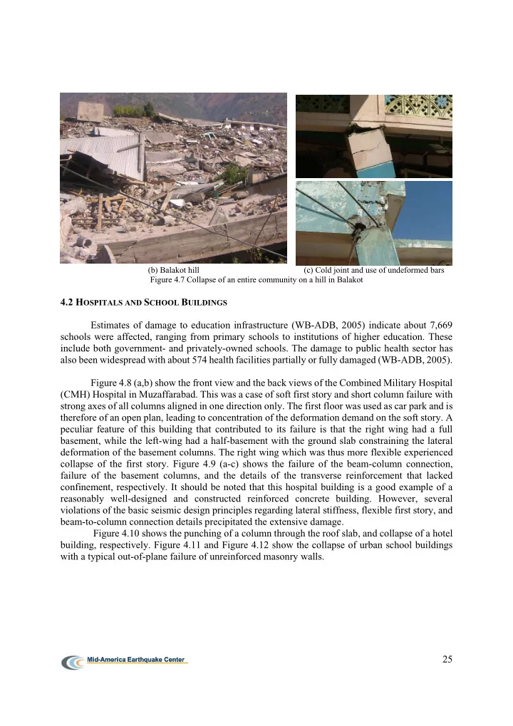
(b) Balakot hill (c) Cold joint and use of undeformed bars Figure 4.7 Collapse of an entire community on a hill in Balakot
4.2 HOSPITALS AND SCHOOL BUILDINGS Estimates of damage to education infrastructure (WB-ADB, 2005) indicate about 7,669 schools were affected, ranging from primary schools to institutions of higher education. These include both government- and privately-owned schools. The damage to public health sector has also been widespread with about 574 health facilities partially or fully damaged (WB-ADB, 2005). Figure 4.8 (a,b) show the front view and the back views of the Combined Military Hospital (CMH) Hospital in Muzaffarabad. This was a case of soft first story and short column failure with strong axes of all columns aligned in one direction only. The first floor was used as car park and is therefore of an open plan, leading to concentration of the deformation demand on the soft story. A peculiar feature of this building that contributed to its failure is that the right wing had a full basement, while the left-wing had a half-basement with the ground slab constraining the lateral deformation of the basement columns. The right wing which was thus more flexible experienced collapse of the first story. Figure 4.9 (a-c) shows the failure of the beam-column connection, failure of the basement columns, and the details of the transverse reinforcement that lacked confinement, respectively. It should be noted that this hospital building is a good example of a reasonably well-designed and constructed reinforced concrete building. However, several violations of the basic seismic design principles regarding lateral stiffness, flexible first story, and beam-to-column connection details precipitated the extensive damage. Figure 4.10 shows the punching of a column through the roof slab, and collapse of a hotel building, respectively. Figure 4.11 and Figure 4.12 show the collapse of urban school buildings with a typical out-of-plane failure of unreinforced masonry walls.
SLIDE 2
26
Mid-America Earthquake Center Mid-America Earthquake Center
Figure 4.8 (a,b). The front and the back views of the Combined Military Hospital (CMH) in Muzaffarabad. Figure 4.9 (a) Failure of the beam-column connection, (b) failure of the ground floor columns, and (c) the details of the transverse reinforcement, CMH Muzaffarabad Figure 4.10 (a) Punching failure of the slab in CMH Hospital. (b) Failure of a Hotel Building in Muzaffarabad.
SLIDE 3
27
Mid-America Earthquake Center Mid-America Earthquake Center
Figure 4.11 Failure of an Urban School Building Figure 4.12 Collapse of a Secondary school
4.3 ROADS AND BRIDGE STRUCTURES Damage to the mountainous roads is largely due to landslides precipitated by the earthquake, as described in more detail in subsequent sections of this report. Figure 4.13 (a,b) show the Balakot Bridge on the Kunhar River which was knocked off its bearing supports. Lack of lateral restraints allowed sliding of the bridge that resulted in one outer girder hanging freely (Figure 4.14 a), and other girders left with minimal bearing over their supports (Figure 4.14 b). Preliminary analysis of the bridge indicates that vertical motion may have played a significant role in reducing the vertical force on the bearings, leading to the large observed lateral displacement. Further detailed analysis will be included in the MAE Center full report. Figure 4.15 shows a Muzaffarabad bridge that also lacked lateral restraints, and was shifted from its supports. Figure 4.16 shows a simply supported bridge over a culvert in the epicentral zone where one of the abutments moved more than 8 feet with respect to the other.
Figure 4.13 (a, b). Balakot bridge that lacked lateral constraint leading to sliding on its bearing supports.
SLIDE 4 28
Mid-America Earthquake Center Mid-America Earthquake Center
Figure 4.14 (a,b). Left girder is hanging free, remaining girders have just 2 inch bearing left, Balakot Bridge Figure 4.15 Lateral sliding of the Balakot Bridge. Figure 4.16 Failure of Bridge abutments.
Bridges along Murree to Muzaffarabad route (Figure 4.17) suffered minor damages such as crushing at expansion joint and abutment due to inadequate expansion/seismic gaps between deck
- segments. Suspension bridges because of their compliant characteristics experienced relatively
little damage. A suspension bridge to the north of Muzaffarabad however completely collapsed as land slides toppled the suspension towers as shown in Figure 4.19.
SLIDE 5
29
Mid-America Earthquake Center Mid-America Earthquake Center
Figure 4.17 Bridges along Murree to Muzaffarabad route, inspect by the MCRU Team (a) Abutment (b) Expansion joint Figure 4.18 Observed damage of bridge at Murree to Muzafarabad Figure 4.19 Collapsed suspension bridge due to land-sliding, North of Muzaffarabad.
SLIDE 6 30
Mid-America Earthquake Center Mid-America Earthquake Center
The MCRU team traveled along the southern Himalayan foothills of Hazara consisting of the Abbottabad and Hazara formations of Cambrian age. The Abbottabad formation extends from the Tarbela area in the west through Abbottabad to Muzaffarabad and Balakot in the east and northeast (Kazmi and Qasim, 1997). The Abbottabad group is formed by a thick dolomite/limestone/marble sequence with quartzitic sandstone layers as well as shale and siltstone. The area is mountainous and is dominated by steep terrain. The city of Muzaffarabad and the town
- f Balakot lie in part within the alluvial valleys of two major rivers, the Jhelum and Kunhar Rivers
- respectively. From a geotechnical perspective the most dominant ground failure mode observed
throughout the earthquake zone is land-sliding and slope instability. The team did not observe first hand evidence of liquefaction or related effects such as lateral spreading and loss of foundation bearing on level ground. However, in meetings with some officials it was noted that there have been cases where “people came out over the roof of a structure, as the entire stories got buried”. We continue to look for evidence of liquefaction as this can be used in the estimate of the level of ground shaking. The following sections highlight the preliminary observations of the site visit team. 5.1 GROUND RUPTURE The causative fault for this earthquake appears to be a blind thrust fault and thus no surface manifestation of fault rupture has been hitherto identified in spite of several teams working in the
- field. The MCRU team received secondary reports about evidence of surface rupture. This issue
remains to be resolved after detailed field investigations by others. It remains unlikely that a confirmed manifestation of the fault rupture will be identified after two months of investigations by land and air, and after the anticipated severe weather. 5.2 LANDSLIDES AND SLOPE INSTABILITY Land-sliding and critical slope stability was a multi-scale problem that ranged from limited sloughing of surficial nature to a scale that encompassed entire mountain sides. The land-sliding problem in the mountains of AJK and NWFP has similarities to land-sliding that occurred in the mountains of Central Taiwan due to the 1999 Chi-Chi earthquake. Figure 5.1 shows a large scale landslide in the Neela Dandi Mountain to the north of Muzaffarabad. The satellite image shows that the landslide blocked the Jhelum River but was rapidly breached. The landslide debris consists
- f shale, limestone and dolomite. Most landslides appear to be in a meta-stable state and can be
readily activated due to aftershocks or rain. Landslide hazard remains high throughout the affected areas. Elsewhere a landslide referred to as the Dandbeh Landslide has blocked tributaries of the Jelhum River (Crone, 2005) and as illustrated in Figure 5.2. Lakes are developing behind these landslides and can potentially result in sudden and significant inundation of areas downstream if the earth dams are breached. These lakes will require careful monitoring to avoid potentially adverse impacts downstream.
SLIDE 7
31
Mid-America Earthquake Center Mid-America Earthquake Center
(a) Satellite image Figure 5.1 Extensive Landsliding in Neela Dandi Mountain, north of Muzaffarabad. Figure 5.2 Development of two lakes south of Muzaffarabad along a tributaries of the Jhelum River due to land-sliding, Dandbeh Landslide, Photo Courtesy of A. Crone, USGS and Digital Globe QucikBird II –Natural Color-Oct 27, 2005.