drone mapping for lora and iot communications
play

Drone Mapping for LoRa and IoT Communications Institute IRNAS Rae - PDF document

IRNAS - Institute for development of advanced applied systems Rae email : info@irnas.eu, web : irnas.eu Drone Mapping for LoRa and IoT Communications Institute IRNAS Rae March 9, 2018 IoT low-power long range networks have become


  1. IRNAS - Institute for development of advanced applied systems Rače email : info@irnas.eu, web : irnas.eu Drone Mapping for LoRa and IoT Communications Institute IRNAS Rače March 9, 2018 IoT low-power long range networks have become widespread and very useful in applications ranging from outdoor agri- cultural and nature observation systems to indoor manufacturing, storage and health and safety applications. The common problem of all these deployments is being unable to clearly map and understand the radio coverage in more complex situations as well as to optimize it for cost effective deployments at scale. We have developed an automated drone RF mapping solution, enabling our customers and ourselves to evaluate the performance of their gateway, ex- actly determine the coverage and understand the effect of the environment on signal coverage. System is applicable for rapid testing of potential gateway locations prior to prematurely investing in infrastructure and to map the radio coverage over large areas and urban environments alike. 
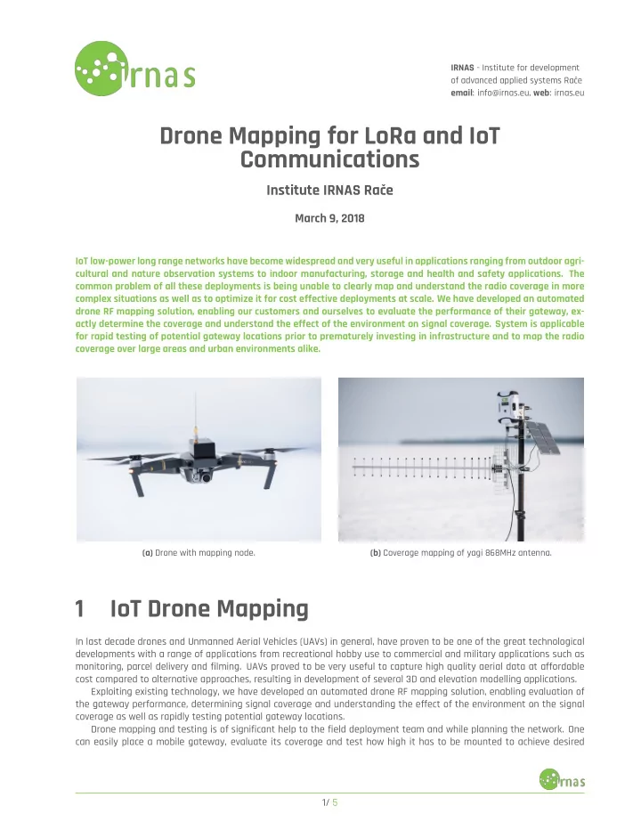
(a) Drone with mapping node. (b) Coverage mapping of yagi 868MHz antenna. 1 IoT Drone Mapping In last decade drones and Unmanned Aerial Vehicles (UAVs) in general, have proven to be one of the great technological developments with a range of applications from recreational hobby use to commercial and military applications such as monitoring, parcel delivery and filming. UAVs proved to be very useful to capture high quality aerial data at affordable cost compared to alternative approaches, resulting in development of several 3D and elevation modelling applications. Exploiting existing technology, we have developed an automated drone RF mapping solution, enabling evaluation of the gateway performance, determining signal coverage and understanding the effect of the environment on the signal coverage as well as rapidly testing potential gateway locations. Drone mapping and testing is of significant help to the field deployment team and while planning the network. One can easily place a mobile gateway, evaluate its coverage and test how high it has to be mounted to achieve desired 1/ 5

  2. IRNAS - Institute for development of advanced applied systems Rače email : info@irnas.eu, web : irnas.eu connectivity from test nodes. Check if trees, forest and other obstacles will limit the performance. 1.1 Optimising LoRa gateway position Gateways in LoRa and LoraWAN networks are the interface between a large area with a significant number of nodes and the cloud. There are a number of scenarios for network coverage provisioning, ranging from public gateway infrastructure to dedicated gateways for specific project and private networks for a particular deployment or a scale deployment of pico gateways. The common factor when rolling out a reliable network is understanding the existing coverage in a given area and determining what coverage has been achieved once gateways have been deployed. The following scenarios can be considered: • No gateways in the area: rolling-out a network to provide connectivity for a new application, where locations of nodes are known. With drone mapping you can rapidly determine the best location for the gateway to provide communication to all nodes. Test the gateway position on a building, tower or other structure by flying the drone next to it, prior to investing into fixed deployment to an incorrect location. • Large-area coverage roll-out: requiring a deployment of multiple gateways. To optimize their placement, avoid coverage blind spots due to land cover and increase the battery life of nodes, the coverage of gateways during deployment can be measured with drone mapping and adjusted in the process to create best coverage with minimal effort and equipment. • Partial public network coverage: where some nodes will be able to connect to existing infrastructure of which coverage may be unknown and some nodes will have no connectivity. With drone mapping the existing coverage in areas of interest can be rapidly determined, blinds spots identified and the locations of additional gateways determined. 1.2 Extending the battery life of node devices The low power nature of LoRaWAN devices enables their battery only operation for a number of years, however it is significantly depending on the signal quality and spreading-factor required to send the information. For example the lower SF7 rate will transmit the message in about 60 ms, while the higher SF12 will require about 1700 ms for the same message, using 28 times more power when transmitting and the operation on a single charge will be that many times shorter, increasing the operating costs of the devices significantly. For example for 1000 devices with battery operation in a given area, if some operate at SF12, they will need to be replaced annually, creating significant costs which can be minimized by using the drone mapping to find optimal gateway positions. Should 30% of devices in the given example require replacing annually, we project the servicing cost in the range of 60.000 EUR annually for the lifespan of devices. Drone mapping and optimization costs are significantly lower then annual cost of servicing. 2 Implementation and Usage Drone mapping implementation has been designed for one of the most cost-efficient and popular drones for aerial pho- tography lately, DJI Mavic Pro with the following key advantages for this use-case: • Widely available: Commonly available around the globe and used by hobby and professional users alike • Flight stability: The drone exhibits very stable flights even under moderate wind conditions and is capable of flying with an additional payload. • Autonomous flight support: Using third-party application complex flight missions can be planned in complex pat- terns. 2/ 5

  3. IRNAS - Institute for development of advanced applied systems Rače email : info@irnas.eu, web : irnas.eu The drone mapping setup for LoRaWAN network we hardware developed consists of a number of software and hard- ware system producing the complete solution. • Drone: DJI Mavic Pro, any latest DJI drone should be easily compatible, other drones subject to additional develop- ment • Drone mapper: A LoRaWAN compatible device sending regular transmissions. With no payload and meeting EU regulations, this results in one packet per about 6s. Velco attached to the drone. • Autonomous flight control: Litcy drone control system is used to runt he flight patch generated by custom software via a CSV file. • Drone path generator: Our custom path generation script which generates a path of concentric circles at a fixed height for coverage mapping, grid of points in a polygon area or a spherical path around the antenna for pattern measurement. • TTN mapper: When used in online mode the drone mapper data is pushed to TTN mapper application, collecting measurements for analysis • LoraWAN gateway: A gateway connected to the TheThingsNetwork system and thus TTN mapper or alternatively a fully offline solution. The user can then select the mapping location and generate the flight path for a specific gateway and plan a path around it accordingly or selects an area to determine the coverage there or one or multiple gateways. Once the flight is completed flight log from the drone and signal log from the TTN mapper are used to create the coverage data. 3 Data Analysis After conducting data during drone flight, the drone measurement log, containing GPS longitude, latitude and altitude position, time-stamp and other flight parameters, needs to be combined with the TTN mapper measurement log containing data on received signal and time. Matching time arrays, obtained data contains information on position and signal. Based on the two flight modes drone path is either a 2D mesh at the same altitude around the antenna or a 3D sphere mesh with the antenna at its central position. Figure 2: 2D coverage map. 3/ 5

  4. IRNAS - Institute for development of advanced applied systems Rače email : info@irnas.eu, web : irnas.eu 3.1 2D coverage Gateway coverage in 2D is most applicable when determining and planning the coverage for a range of devices in a certain area, either connected to one or multiple gateways. When imported into GIS software one can observe effects of the environment, such as shadowing of the trees and other obstacles as well as the coverage contributions of individual gateways. 3.2 Antenna radiation pattern The 3D spherical data is used to determined 3D antenna radiation pattern and corresponding x-y azimuth plane cut and the x-z elevation plane cut. Data is first filtered, eliminating all measurement points during landing stage that could alter the result and then converted to spherical coordinates for further analysis. Signal values are normalised. All points are assumed to be located on a surface of a sphere thus having constant radius, where all points located outside set tolerance bound are discarded. Measured signal is then interpolated on a spherical mesh, then a 3D surface plot can be produced, using interpolated polar and azimuthal angles and signal as the radius. (a) 1/4 wave omni antenna (b) Colinear antenna with visible sidelobes Figure 3: 3D radiation pattern obtained from drone mapping measured data. Direction of the x axis is determined by the maximal signal gain, while for scanned antenna z axis has remained perpendicular to the earth surface. Subsequent x-y azimuth plane cut is produced from the bottom layer at the antenna level, while x-z elevation plane cut has the azimuthal angle set in the direction of maximal gain. While such approach of determining axis orientation works well with antenna settings where z axis is supposed to be perpendicular to the ground, procedure can be adapted based on the produced 3D radiation plot and antenna properties. 4/ 5

Download Presentation
Download Policy: The content available on the website is offered to you 'AS IS' for your personal information and use only. It cannot be commercialized, licensed, or distributed on other websites without prior consent from the author. To download a presentation, simply click this link. If you encounter any difficulties during the download process, it's possible that the publisher has removed the file from their server.

Recommend


More recommend