DONLIN GOLD PROJECT TO M WA LD O an d IR IS KO R HO N E N-PE N N - - PowerPoint PPT Presentation

donlin gold project
SMART_READER_LITE
LIVE PREVIEW

DONLIN GOLD PROJECT TO M WA LD O an d IR IS KO R HO N E N-PE N N - - PowerPoint PPT Presentation

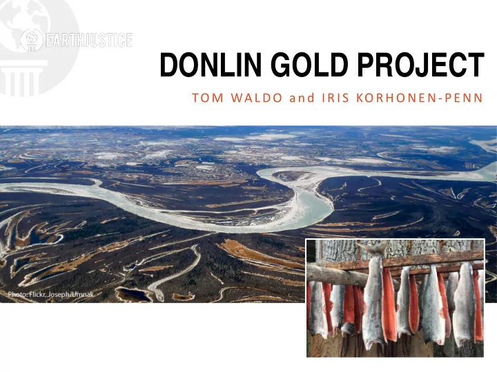
DONLIN GOLD PROJECT TO M WA LD O an d IR IS KO R HO N E N-PE N N DONLIN MINE SITE (2013) DONLIN GOLD PROJECT Located in SW Alaska, along Crooked Creek, a tributary to the Kuskokwim River. One of the biggest gold mines in the


slide-1
SLIDE 1

DONLIN GOLD PROJECT

TO M WA LD O an d IR IS KO R HO N E N-PE N N

slide-2
SLIDE 2
slide-3
SLIDE 3

DONLIN MINE SITE (2013)

slide-4
SLIDE 4

DONLIN GOLD PROJECT

  • One of the biggest gold mines in the world.
  • 27-year mine life.
  • Located in SW Alaska, along Crooked Creek, a

tributary to the Kuskokwim River.

  • 1.6 million tons ore.
slide-5
SLIDE 5
slide-6
SLIDE 6

OPEN PIT

  • 2.2 miles x 1 mile, up to 1800 feet deep.
  • 1,462 acres.
  • Upon closure, pit will fill up with contaminated

water to form a permanent lake that will never meet water quality standards and require water treatment in perpetuity.

  • Two pits, ACMA and Lewis, eventually merged.
slide-7
SLIDE 7

Goldstrike Betze Mine

slide-8
SLIDE 8

TAILINGS

  • Wet storage behind 471 foot high dam
  • 600 million tons of tailings
  • 2,400 acres
slide-9
SLIDE 9

WASTE ROCK

  • 2,500 acres
  • 2.5 billion tons waste rock, some acid

generating.

slide-10
SLIDE 10

INFRASTRUCTURE

  • 122 barge round trips/year in short 4-5 month

season

  • 316-mile natural

gas pipeline from Cook Inlet

  • Water treatment plant—average 2,800

gallons/minute

slide-11
SLIDE 11
slide-12
SLIDE 12
slide-13
SLIDE 13

HABITAT DAMAGE

  • 10 miles of streams destroyed—half with fish
  • Dewatering of salmon streams
  • 6,500 acres wetlands disturbed.
  • Barge damage to spawning areas for

rainbow smelt

slide-14
SLIDE 14
slide-15
SLIDE 15

WATER QUALITY

  • “Mercury belt”—atmospheric deposition
  • Arsenic leaching from waste rock to

groundwater

  • Temperature increases from dewatering
  • Risk of tailings dam failure
  • Post-closure: perpetual water

treatment

  • Mt. Polley Dam Failure
slide-16
SLIDE 16

SOCIAL IMPACTS

  • Constant barge traffic in summer
  • 2,500 construction workers—600+ in
  • perations
slide-17
SLIDE 17

PROJECT STATUS

  • Final Environmental Impact Statement issued

April 2018

  • Joint Record of Decision signed by

Army Corps and BLM on August 13, 2018

  • Army Corps: 404 permit
  • BLM: Pipeline Right-of-Way
slide-18
SLIDE 18

STATE OF ALASKA PERMITS

  • 401 Certification issued by DEC August 10,

2018; appealed by Tribes.

  • Title 16 permits issued by ADF&G August 30,

2018.

  • Reclamation and Closure Plan; comments

submitted to DEC and DNR September 6, 2018.

slide-19
SLIDE 19

MORE STATE OF ALASKA PERMITS

  • Water Use Permits from DNR forthcoming.
  • Dam Safety Permit from DNR forthcoming.
  • State Land Use Authorizations from DNR

forthcoming; Best Interest Finding.

slide-20
SLIDE 20

CONTACT EARTHJUSTICE

  • Olivia Glasscock, Attorney, 907.500.7134,
  • glasscock@earthjustice.org.
  • Iris Korhonen-Penn, Legal Assistant,

907.500.7126, ikorhonen@earthjustice.org.

  • Tom Waldo, Attorney, 907.500.7123,

twaldo@earthjustice.org. On leave Sept. 15, 2018, to Jan. 1, 2019.

slide-21
SLIDE 21

/ e a r t h j u s t i c e @ e a r t h j u s t i c e e a r t h j u s t i c e . o r g