SLIDE 1
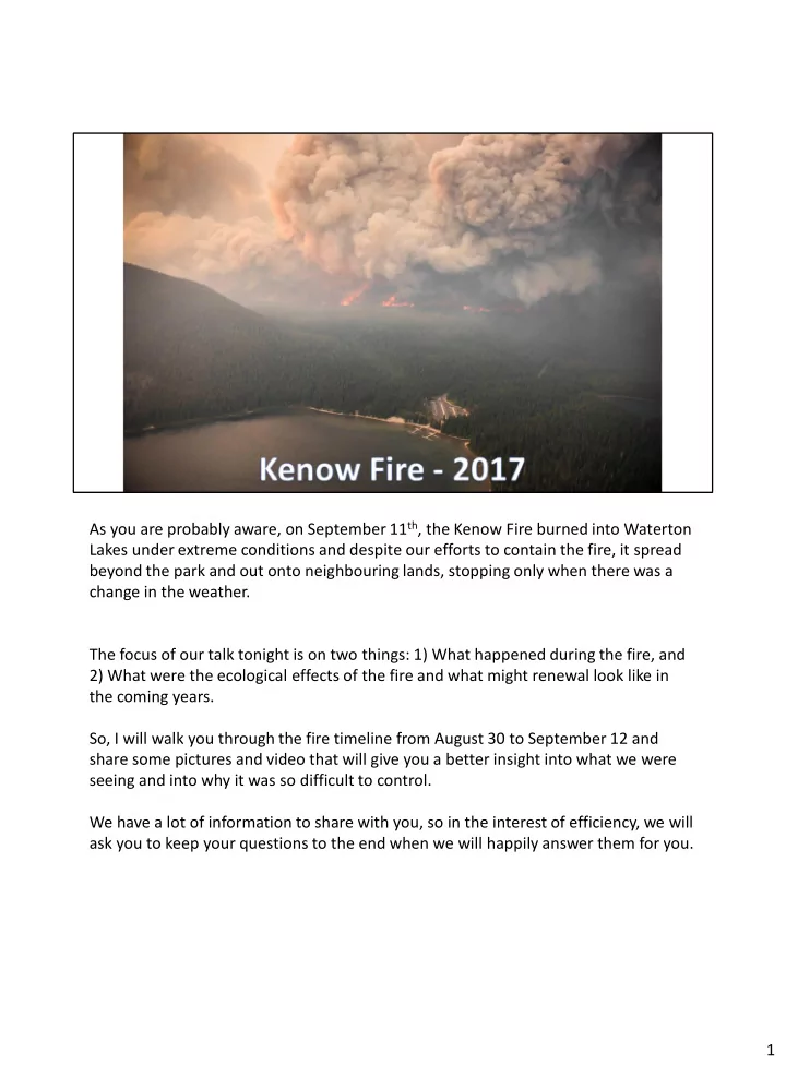
As you are probably aware, on September 11th, the Kenow Fire burned into Waterton Lakes under extreme conditions and despite our efforts to contain the fire, it spread beyond the park and out onto neighbouring lands, stopping only when there was a change in the weather. The focus of our talk tonight is on two things: 1) What happened during the fire, and 2) What were the ecological effects of the fire and what might renewal look like in the coming years. So, I will walk you through the fire timeline from August 30 to September 12 and share some pictures and video that will give you a better insight into what we were seeing and into why it was so difficult to control. We have a lot of information to share with you, so in the interest of efficiency, we will ask you to keep your questions to the end when we will happily answer them for you. 1
SLIDE 2 A quick recap... 2017 was a very dry summer. Third driest on record in Waterton, just barely behind 1969 and 2007. 2007 you will recall, was the last time, before this past season, that the province closed the Forest Reserve to the public because of fire danger. We had 14 fires in the park in 2017, and with the exception of the Kenow Fire, all were extinguished the day they were found, and none grew bigger than this stage. In June, at many of our weather stations around the park, we only received about 1/2
- f our normal precipitation, so by early July we are into Extreme Fire Danger, and the
fire crew and helicopter are on high alert in the park. On July 17th we put on a fire ban, but despite that we continue to find illegal campfires, and so on August 9th we implement a partial backcountry closure: no camping in the backcountry, no travel off of hiking trails. Two reasons: 1) Reduce potential for human-caused fires; 2) New fires are going to grow quickly and we want to be able to locate and evacuate hikers efficiently. We want to be able to sweep the trails and know that we have gotten everyone out of harms way. 2
SLIDE 3
So, as it got drier and fire danger increased, we were stepping up our prevention and preparedness measures in the park. 2
SLIDE 4
This is a series of satellite images from the early evening of August 30th. You can see our location in the middle of that red circle where the B.C. / Alberta / Montana borders meet. The white you see are clouds. Note the large thunder cell that develops in Montana and moves north up the Flathead Valley resulting in many lightning strikes and new fires. 3
SLIDE 5
Orient people to the Alberta / B.C. border, U.S.A. border, Cameron Lake, Waterton townsite. This is a lightning detection map from the night of August 30th... we can watch lighting strikes hit the ground in real time. That night I am sitting in the Warden Office watching those satellite images and watching these lightning strikes pop up on the screen. After the storm passes and it is safe to fly, the crew heads out in the helicopter with all their gear on a smoke patrol and finds a new fire to the west of the park. 4
SLIDE 6
The crew discovered a new, 5 hectare fire on Kenow Mtn about 12 km west of the park boundary at about 6:45 p.m. They take these pictures, which are a good illustration of why the fire could not be immediately extinguished. Within an hour of lightning starting that fire, it was already too big, burning too intensely, and growing too fast in steep and remote terrain. Under these conditions, an initial attack crew and a single helicopter are not effective on that fire. Fire was immediately reported to B.C. Wildfire’s South East Fire Centre in Castlegar, B.C. and the crew continued on patrol looking for a smaller new fire where they could be effective. We would have loved to have put this fire out, but unfortunately, it was beyond us. To be clear, Waterton Lakes is a full suppression park. We do not have a 'let burn' policy in Waterton Lakes. We do have agreements in place with our neighbours that allows us to take initial action inside their jurisdictions... we have put out new fires in B.C., the Forest 5
SLIDE 7
Reserve, Glacier NP and in Cardston County and the MD of Pincher Creek before. So the reason we didn’t put it out was not because we didn’t want to, it was not because we weren’t allowed to, it was because we couldn’t…. At one hour old, it was already beyond our capability to put out: it was too big and burning too intensely. This is the kind of fire that we were concerned about when we put on the backcountry closure… this is the kind of fire that gave fire managers all across western North America trouble in 2017 as they grew larger and larger, out of control, until the rain came. 5
SLIDE 8 Fire grew from 5 ha to over 50 ha overnight and then continued to grow over the next several days. This picture shows the types of conditions we were experiencing many days. Some days the smoke is so thick that we are not able to see or get to the fire, or use aircraft to drop water or retardant on the fire. You can see Mt. Blakiston, tallest mtn in Waterton and Mt. Cleveland, tallest mountain in Glacier NP poking up through the cloud and smoke. So when airtankers are sitting on the ground at the Pincher Creek airport, or helicopters are on the ground in Waterton, it’s not because we haven’t thought to use them. 1) We can't see the fire or other aircraft... Not safe. 2) It's too windy/turbulent... Not
- safe. 3) The topography is too tight for airtankers to work… not safe. Those are big,
heavy loads and they need room to safely manoeuver. 6
SLIDE 9
Aircraft are an incredible tool, but they are not a silver bullet. There are limitations to where, when and how they can be used. 6
SLIDE 10
On the evening of September 2nd, the fire makes a 7km run to the NE and stops at the Continental Divide / park boundary. Ash is raining down on Twin Butte. As soon as we saw this run, we knew that there was potential for the fire to spread into the park and affect the townsite in a short amount of time, given similar conditions. The extended forecast at that point was full of similar conditions and short on any kind of relief. 7
SLIDE 11 When the smoke clears we are able to determine that there is only one small spot fire within the park (0.5 ha) – size of a football field. This is a minor miracle. Orient people: AB/BC border …. Twin Lake / Snowshoe Trail / Red Rock Canyon Helicopters are immediately dispatched to drop buckets of water on the fire. You can see the intensity with which the fire burned… hardly a green tree remains on the B.C. side of the border. Try to imagine what it must have looked like that evening… the number of embers, burning branches, spruce cones, pine cones, flying through the air across the Divide. Incredibly fortunate that we only ended up with
8
SLIDE 12
We have three broad objectives: 1) Keep the fire west of the Divide; 2) Failing that, contain the fire within the park; 3) Prepare for the fire’s arrival– protection of infrastructure in the park, alerts and progressively larger and more restrictive closures and evacuations, ensuring “business continuity” – the ability to operate following a worse-case scenario The fire has a few likely paths into the park over low, treed passes along the Divide. Sage Pass burned out in the initial run, South Kootenay Pass and Akamina Pass near Cameron Lake are problematic. 9
SLIDE 13
Keeping the fire west of the Divide. Knowing that the weather in a couple of days will cause the fire to take a big run at South Kootenay Pass and likely spot and spread into the park, we take advantage of more favourable conditions and burn out fuels along the west side of the Divide beforehand, below South Kootenay Pass, starving the fire of fuel. We’re essentially trying to put a cork in the bottle and keep the Genie inside the bottle. This operation is successful and fire never does cross the Divide at this location…. This probably buys us 2 or 3 days of time and prevents the fire from spreading down the Red Rock Rock parkway sooner than it did. 10
SLIDE 14
In anticipation of the fire entering the park, we identify strategic locations on the landscape where we will attempt to slow or contain the fire. Avalanche paths, rock slides, dry creek beds, bare cliffs all provide some opportunity. We set up a sprinkler line around the perimeter of town and we also cut out fire guards and install big hose and sprinklers along them near Lineham Creek, on Bellevue Hill along the RR Parkway, and across the Eskerine (Badlands). 11
SLIDE 15
1) Protection of infrastructure in the park, 2) Progressively larger and more restrictive closures, evacuation alerts and notices 3) Ensuring “business continuity” – the ability to operate following a worse-case scenario . 12
SLIDE 16
NOTICE IT IS DAYLIGHT IN THESE PHOTOS. Crews can’t work at night. 13
SLIDE 17
14
SLIDE 18
15
SLIDE 19
16
SLIDE 20
On the afternoon and evening of September 10th the fire moves about 5 km down the Akamina Valley. An early morning flight on September 11th reveals a new spot fire (50 ha) in Tamarack Basin. We initially have 4 helicopters bucketing on that 50 ha spot fire, but they are only able to cool down active spots, not put it out, and smoke and swirling winds eventually force them to abandon their mission. 17
SLIDE 21 The fire continues to move south down the Akamina Valley and enters the park at Akamina Pass around 5:30 pm. It is burning with extreme intensity and moving at a fairly rapid rate of speed. Orient them to location: We are in the helicopter basically over the Cameron Lake day use area… Forum Lake and Wall Lake are just off screen to the left. We are going to fly down the flank of the fire towards the head, or front, of the fire. Akamina Parkway will appear in the bottom of the screen. The trees here are 50 – 100 feet tall, so the flames we can see are several hundreds
5:32 p.m. 18
SLIDE 22
Another look from a little closer. Flame heights are several hundreds of feet above the tree tops. We are probably ¼ mile away from the fire and I can feel the heat through the plastic window on the helicopter. 19
SLIDE 23
Here are a series of that show just how explosive the conditions are. The forest was so dry and burning conditions so severe, that even small spot fires ahead of the main fire quickly develop into larger fires. We were seeing spots fires ignite several km in front of the main fire front. The forest was this dry all the way through the event. This is why we put on the partial backcountry closure. This is why the fire grew so quickly on the night it started. 20
SLIDE 24
Here are a series of that show just how explosive the conditions are. The forest was so dry and burning conditions so severe, that even small spot fires ahead of the main fire quickly develop into larger fires. We were seeing spots fires ignite several km in front of the main fire front. The forest was this dry all the way through the event. This is why we put on the partial backcountry closure. This is why the fire grew so quickly on the night it started. 21
SLIDE 25
Here are a series of that show just how explosive the conditions are. The forest was so dry and burning conditions so severe, that even small spot fires ahead of the main fire quickly develop into larger fires. We were seeing spots fires ignite several km in front of the main fire front. The forest was this dry all the way through the event. This is why we put on the partial backcountry closure. This is why the fire grew so quickly on the night it started. 22
SLIDE 26
23
SLIDE 27
1103 p.m. Fire behaviour typically settle down at night as the temperatures drop and the humidity increases, but not this night. 24
SLIDE 28
1109pm 25
SLIDE 29
26
SLIDE 30 This the situation we were faced with… the strategy was to attempt to corral as much
- f the fire as we could within the Entrance Road, Highway 6 and the gravel road down
to Indian Springs. The purpose of a burnout is to remove fuels between a control line and the fire. Similar to what we did at South Kootenay Pass, but on the ground and at a different scale. Crews would start from Indian Springs and from Knight’s Lake Day Use Area and work towards each other, meeting on Hwy 6. The burnout operation had barely begun when a Park Warden travelling down Highway 6 got on the radio and reported that the main wildfire had spread from the Eskerine (Badlands) across Highway 6 and was headed to the northeast. Red = burnout lines Blue = Sprinkler lines 27
SLIDE 31
In this video there is clearly at least 2 fires discontinuous spot fires burning on the Eskerine as can be seen late in the video, plus the fire on Crandell Mtn, plus the fire at the gate, plus the fire across the lake. 28
SLIDE 32
29
SLIDE 33
NOTE THE FAR SIDE OF KNIGHTS LAKE. That night the fire moved through the park at a high rate of spread. The fire entered the park at 5:30 pm and by 10:30 pm was out the park on the other side - about 20 km. (spend a bit of time describing how the fire spread: down Cameron Valley, from Tamarack Basin down Blakiston Valley, into Horseshoe Basin, etc. The townsite and Cameron and Blakiston Valleys were all over run and the fire exited the park to the north east. 31
SLIDE 34
On the morning of the 12th we finally get the change in weather that we had been waiting for. Wind direction and speed become more favourable and humidity's climb well out of the teens. Between 6 am and 7 am the temperature drops from 16 to 12 degrees and the humidity doubles from 33% to 66%. At midnight, it had been 23 degrees and the humidity 16%. The winds have switched direction and are now blowing out of the north, pushing the fire back on to itself, and wind speeds are down from the 30s and 40s and only around 5 km/h. This is a picture taken that morning from the intersection of Hwy 6 and Oil Basin Road, looking west. Rain is on the way. 32
SLIDE 35
Overlay of the Kenow Fire perimeter on the City of Calgary for size comparison. Kenow Fire was 35,000 ha …. Lost Creek Fire in 2003 was 22,000 ha. 2015 FIRE NEAR GOAT HAUNT 2017 KENOW FIRE 2018 BOUNDARY CREEK FIRE 33
SLIDE 36
34