abbey lane verification of slow response flows
play

Abbey Lane Verification of Slow Response Flows By Simon Lewis, - PDF document

Abbey Lane Verification of Slow Response Flows By Simon Lewis, Clear Environmental Consultants Ltd The Abbey Lane Drainage Area Zone (DAZ) is in the south west of Sheffield and was verified as part of the Yorkshire Water AMP5 DAP programme.


  1. Abbey Lane – Verification of Slow Response Flows By Simon Lewis, Clear Environmental Consultants Ltd The Abbey Lane Drainage Area Zone (DAZ) is in the south west of Sheffield and was verified as part of the Yorkshire Water AMP5 DAP programme. The modelled area covers approximately 500 hectares and comprises 2319 nodes. 116 flow and depth monitors were installed across the catchment between May and June 2012. Flow monitor data from approximately 40 flow and depth monitors installed in the Jordanthorpe, Batemoor and Lowedges areas, in the south of the catchment, displayed significant slow response flows induced by rainfall. These areas are served by extensive surface water and foul systems which might appear to be separate on initial inspection. Some of the observed slow response appeared to be made up of two distinct flow profiles, one quicker and one slower, this was predominantly observed in the foul/combined systems. This paper documents the investigations into the sources of the slow response flows and details the technical requirements for representing them in InfoWorks. The Ground Infiltration Module 
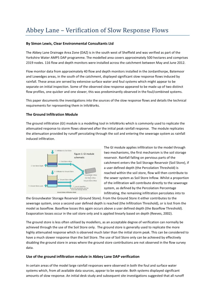
The ground infiltration (GI) module is a modelling tool in InfoWorks which is commonly used to replicate the attenuated response to storm flows observed after the initial peak rainfall response. The module replicates the attenuation provided by runoff percolating through the soil and entering the sewerage system as rainfall induced infiltration. The GI module applies infiltration to the model through two mechanisms, the first mechanism is the soil storage Figure 1: GI module reservoir. Rainfall falling on pervious parts of the schematic catchment enters the Soil Storage Reservoir (Soil Store), if a user defined depth (the Percolation Threshold) is reached within the soil store, flow will then contribute to the sewer system as Soil Store Inflow. Whilst a proportion of the infiltration will contribute directly to the sewerage system, as defined by the Percolation Percentage Infiltrating, the remaining infiltration percolates into to the Groundwater Storage Reservoir (Ground Store). From the Ground Store it either contributes to the sewerage system, once a second user defined depth is reached (the Infiltration Threshold), or is lost from the model as baseflow. Baseflow losses this again occurs above a user defined depth (the Baseflow Threshold). Evaporation losses occur in the soil store only and is applied linearly based on depth (Reeves, 2002). The ground store is less often utilised by modellers, as an acceptable degree of verification can normally be achieved through the use of the Soil Store only. The ground store is generally used to replicate the more highly attenuated response which is observed much later than the initial storm peak. This can be considered to have a much slower response than the Soil Store. The use of Soil Store only can be achieved by effectively disabling the ground store in areas where the ground store contributions are not observed in the flow survey data. Use of the ground infiltration module in Abbey Lane DAP verification In certain areas of the model large rainfall responses were observed in both the foul and surface water systems which, from all available data sources, appear to be separate. Both systems displayed significant amounts of slow response. An initial desk study and subsequent site investigations suggested that all runoff

  2. would drain to the storm system. No evidence of soakaways or any other formal attenuating mechanisms were identified. Initial attempts at verifying the slow response flow in both systems using impermeable and New UK runoff, did not provide a good fit with the observed data. It became evident that very little impermeable area was contributing directly to the foul system therefore it was considered that the majority of the response occurred as a result of ground infiltration processes. The GI module was then utilised to try to replicate the observed slow response. Initial trails using a single GI profile based on Soil Store parameters only, resulted in only partial matches with the observed data. It became evident that two distinct elements of slow response were acting: a relatively quick initial response followed by slower, longer duration, response. Model tests showed that these two elements could not be replicated using a single GI profile using only contributions from the Soil Store. In an attempt to improve verification of the observed slow response flows, the use of two separate Soil Store only ground infiltration profiles, one faster profile and one slower profile, was tested. In order to apply two different ground infiltration profiles upstream of a given flow monitor it was necessary to apply one profile to the existing digitised upstream subcatchments and the other to a new dummy subcatchment. The addition of dummy subcatchments resulted in 156.5 Ha of dummy area being applied to the model in 21 different dummy subcatchments. A Comparison of the various runoff modules available in InfoWorks CS indicated that the very Figure 2: Range of runoff slow response observed on the foul system may responses in InfoWorks potentially be due to contributions from the Ground Store. By altering the properties of the two different Soil Store only profiles to replicate the highly attenuated observed flows the runoff contributions from the ground store, which had not been utilised at this stage, were being replicated through the application of dummy area. In an effort to simplify the modelling approach it was decided to test the application of the ground store element of the ground infiltration module in the Abbey Lane DAP model. If successful this would remove the need to include the 21 dummy subcatchments modelled previously. Utilisation of the Ground Store The ground store was enabled in the GI file by specifying a groundwater level type ‘REL’ in the sub-event parameters. An initial groundwater level of 0.0m was applied to cause contributions from the Ground Store to occur immediately as suggested by the observed data. No groundwater level data was available to suggest an initial groundwater level in the catchment. The subsequent runs produced reasonable model predictions at a number of flow monitor sites in the foul system. Once the ground store had been activated, predicted slow response flows at several flow monitor sites across the catchment, were significantly over predicted. It was considered that the Ground Store was not contributing in these locations, possibly due to lower groundwater levels in these areas (relative to the invert levels of the sewer network), as indicated in areas with separate systems in which the ground store inflows were only observed in the deeper of the two systems. Other factors such as greater structural integrity of the sewer network may also be a contributing factor. In these areas where slow response flows were significantly over predicted the Ground Store was disabled.

Download Presentation
Download Policy: The content available on the website is offered to you 'AS IS' for your personal information and use only. It cannot be commercialized, licensed, or distributed on other websites without prior consent from the author. To download a presentation, simply click this link. If you encounter any difficulties during the download process, it's possible that the publisher has removed the file from their server.

Recommend


More recommend