A training exercise in Cyprus demonstration of services devel- - - PowerPoint PPT Presentation

a training exercise in cyprus
SMART_READER_LITE
LIVE PREVIEW

A training exercise in Cyprus demonstration of services devel- - - PowerPoint PPT Presentation

simulated earthquake. The notional of Cyprus and causing major damage GMES Project (Land/Sea Integrated in the headquarters. The German Agency a joint exercise was carried out by the erating from its General Headquarters and mapping equipment.


slide-1
SLIDE 1

56

W INDOW ON GMES

57

W INDOW ON GMES

demonstration of services devel-

  • ped by the “Humanitarian Relief and

Reconstruction” cluster of the LIMES GMES Project (Land/Sea Integrated Monitoring for European Security). Thus, a joint exercise was carried out by the AMC and LIMES in June and November 2008 in order to test optimised process- ing chains and prototypes developed within a realistic disaster scenario. One of the objectives of the LIMES project is the development of satel- lite-based services providing relevant information and decision-support tools for the organisation and distribution of humanitarian relief and reconstruction. Another objective is to test and dem-

  • nstrate possibilities for collaboration

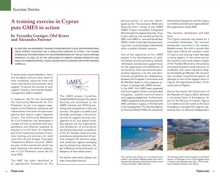
between the European Commission and EU Member States in crisis response ac- tivities, in synergy with LIMES services. In the AMC, the LIMES team prepared technical support actions and provided navigation, satellite communications and mapping equipment. Furthermore, LIMES supported and accompanied the AMC activities in Cyprus, in the field and in the headquarters. The German Agency for Technical Relief (THW), the Johanniter International Assistance and the Cyprus Civil Defence (CCD) were responsible for the organisation of the AMC. The scenario: earthquake and tidal wave The Cyprus exercise was based on a simulated earthquake. The notional earthquake occurred in the eastern Mediterranean Sea with a tsunami-like tidal wave hitting the southern coast

  • f Cyprus and causing major damage

in some regions. In the centre and on the southern and south-eastern slopes

  • f the Troodos Mountains, the scenario

simulated blocked roads because of landslides, with some individual villag- es and dwellings affected. The scenario also included ‘unconfirmed reports’ of damage to one of the biggest dams in Cyprus, the Asprokremnos dam, 15 km south-east of Paphos. Due to the events, the Government of the Republic of Cyprus (GoC) declared a simulated State of Emergency. As part of the Ministry of Interior, Cyprus Civil Defence (CCD) acted as the local emergency management agency op- erating from its General Headquarters In recent years natural disasters, indus- trial accidents and civil wars, seem to have multiplied, requiring more and more international humanitarian relief

  • support. To secure the success of such

support missions, well-trained disaster management staff is needed. In response, the EU has developed the Community Mechanism for Civil

  • Protection. Its aim is to support coop-

eration in Civil Protection assistance and interventions in the event of major emer- gencies that require urgent response

  • actions. The Community Mechanism

for Civil Protection has developed a number of tools to facilitate both pre- paredness and effective response to disasters at an EU level. An important part of the mechanism consists of com- mon training and seminars for relief units from all over Europe. One-week “Assessment Mission Courses” (AMC) are part of this mechanism which has been fostering international coopera- tion in Civil Protection across the EU since 2002. The AMC has been identified as an appropriate framework for the

IN JUNE 2008, AN ASSESSMENT TRAINING COURSE BROUGHT LOCAL AND INTERNATIONAL CRISIS EXPERTS TOGETHER FOR A SIMULATION EXERCISE IN CYPRUS. THE COURSE INTRODUCED THE PARTICIPANTS TO THE APPROPRIATENESS OF THE EU’S MULTI-PARTNER APPROACH, AS WELL AS TO THE USEFULNESS OF REMOTE SENSING PRODUCTS AND SATELLITE COMMUNICATIONS. IT ALSO YIELDED POSITIVE LESSONS FOR FUTURE TRAINING CURRICULA.

A training exercise in Cyprus puts GMES in action

by Veronika Gstaiger, Olaf Kranz and Alexandra Foerster Success Stories

The LIMES project (Land/Sea Integrated Monitoring for European Security) will contribute to the GMES initiative until 2010 by pro- viding core competence in Security

  • services. The goal is to define and

develop prototype information services to support security man- agement at EU and global levels. Key aspects are the organisation and distribution of humanitarian aid and reconstruction; surveillance

  • f the EU borders (land and sea);

surveillance and protection of mari- time transport for sensitive cargo; and, protection against emerging security threats (e.g. terrorism, ille- gal trafficking and proliferation of weapons of mass destruction). For further information please visit http://www.fp6-limes.eu/

The training scenario also included ‘unconfirmed reports’ of damage to one of the biggest dams in Cyprus, the Asprokremnos dam, 15 km south- east of Paphos (Credits: Paul Taylor). The exercise was based on a simulated earth- quake in the eastern Mediterranean Sea with a tsunami-like tidal wave hitting the southern coast

  • f Cyprus (Credits: Willis Davison).
slide-2
SLIDE 2

58

W INDOW ON GMES

59

W INDOW ON GMES

Success Stories

After the Cypriot government sent a (simulated) request for international assistance to the European Union, the European Commission activated the Community Mechanism and delegated an EU Assessment Team consisting of experts from Member States. The training course started with the arrival of the participants and an introduction to the most important information about Cyprus and the ex- ercise itself. After the scenario started, the LIMES consortium trialled, jointly with the AMC team, their communica- tion and analysis capacities. The major mission of the assessment teams was to arrange appointments with key organisations in the disaster area and to gather information about the impact of the disaster on infra- structure and on people. The course participants were therefore divided into three groups taking charge of evaluat- ing the situation in different regions and

  • rganisations.

Support from the LIMES team During the exercise, the LIMES team played a supportive role in rapid situation assessment. It provided products for communication and navi- gation and demonstrated the benefit of in the southern outskirts of Lefkosia and from several Civil Defence District Headquarters under the authority of the respective District Officers. Assessment teams of Cyprus Civil Defence, the District Officers and the Mayor’s Offices of the major cities conducted preliminary evaluations of af- fected buildings and infrastructure. Teams from the Ministry of Communication and Works were mobilised to restore essential infrastructure (water supply, communica- tion, roads, airports etc.).

Briefing in the field using one of the satellite- based maps (Credits: DLR). This overview map shows the simulated spread of the tsunami-like tidal wave and the affected regions in the southern part of Cyprus (Credits: LIMES project, DLR/ZKI).

Organisations responsible for the Cyprus Assessment Mission Course The German Federal Agency for Technical Relief (THW) is the op- erative civil protection organisation of the Federal Government

  • f Germany. THW provides technical assistance both within

Germany and abroad. Nationwide, more than 80,000 citizens volunteer in these activities at 668 local THW sections. THW offers a wide range of services, from acute emergency aid to long-term partnerships for civil reconstruction. Its “Rapid Deployment Units” enable the THW to react quickly and provide emergency humanitarian relief in case of crisis. The Johanniter International Assistance (Johanniter- Unfall-Hilfe (JUH) consists of 200 national, regional, and local associations throughout the Federal Republic

  • f Germany.

It is a professional association of “Diakonisches Werk” of the “Evangelical Church

  • f Germany” (EKD), and it is recognised as a voluntary relief organisation for

charitable and non-profit purposes. Building on the national medical expertise

  • f JUH, Johanniter’s international assistance concentrates on providing basic

medical care to people living in disaster areas and in particularly disadvantaged regions of the world. In the event of a disaster, Johanniter can mobilise and coordinate a number of experienced full-time and volunteer members. The main mission of Cyprus Civil Defence is the performance

  • f various humanitarian tasks intended to protect the civilian

population and help it recover from the immediate effects of hostilities or disaster as well as to provide the conditions neces- sary for survival. The Civil Defence Force is organised by the establishment of civil defence units in almost all the urban areas and all the villages near the ceasefire line. Most of the units consist of conscripts and volunteers. Civil Defence members receive initial training and are further trained and positioned in different divisions of Civil Defence, for example the Sections of First Aid, Telecommunications, Welfare, Fire Fighting, Rescue and the Neighbourhood Watch Sections.

slide-3
SLIDE 3

60

W INDOW ON GMES

61

W INDOW ON GMES

the LIMES team handed out updated situation maps and damage assessment maps which contained information gath- ered by field workers. The maps were sent as pdf-files to the assessment team and integrated into Mapcases – a communication tool de- veloped by the German Aerospace Center (DLR) within the LIMES project. A Mapcase consists of a touch screen computer and several features for com- munication via satellite. It provides the

  • pportunity to add such information

as geo-coded pictures from a digital camera to a Point of Interest (POI). It features a Google Earth-like view with the capacity to adjust the fjnal map to individual requirements (panning, zoom- ing, activating/deactivating layers etc.) and to exchange information with other field teams or the back office. The field workers can also use the Mapcases to write assessment reports with the assistance of an interactive

  • wizard. The reports are produced to

the United Nations Disaster Assessment Coordination (UNDAC) standard and can be linked to selected POIs. satellite-based maps, information and communications, which can be used for situation assessment and preparation of

  • briefings. Several map products (over-

view, situation and damage assessment maps) were generated during the differ- ent phases of the simulated disaster. During a real crisis, input data is available at different points in time depending

  • n the task load of the satellites, the

amount of pre-processing needed, and the information to be extracted from the imagery. During the AMC the map- ping products were delivered as they would have been in a real emergency situation. On the first day of the exercise, the relief units received satellite-based overview (base) maps. These maps showed po- tentially affected regions and the spread

  • f the tsunami-like tidal wave based on

archive satellite image data (see an ex- ample on p. 59). On the next day, the participants re- ceived situation maps presenting a first analysis of the impact of the earthquake and the subsequent tsunami. These maps were based on newly acquired satellite images. Finally, on the third day

Success Stories

The situation map shows a pre- versus post- disaster comparison of the Asprokemmos dam in Cyprus. On the left hand the pre-disaster image is displayed; on the right the simulated dam breach can be

  • seen. (Credits: LIMES project, DLR/ZKI).

Cyprus Civil Defence testing one of the Mapcases (Credits: DLR). One of the field teams works with the Mapcases (Credits: DLR). On the damage assessment map the simulated damage classes are displayed in different colours (red being the colour indicating the worst damages) (Credits: LIMES project, DLR/ZKI).

slide-4
SLIDE 4

62

W INDOW ON GMES

63

W INDOW ON GMES

The joint activities of the AMC and LIMES demonstrated not only that GMES services are of great benefit to disaster managers in the field, but also that a joint approach by different part- ners working at various locations all over Europe can be a very effective and rapid approach for delivering complex disas- ter management services. The division

  • f labour by individual fields of expertise

results in sound and reliable information products that can be rapidly distrib- uted to the organisation that requests

  • it. The latter is of particular importance

in building acceptance for the services being provided, as it is crucial for sup- porting needs assessments. The discussions with almost all course participants and trainers as well as with the course organisers about disaster management in general and the benefit

  • f satellite-based information in particu-

lar resulted in a more precise picture of user requirements. This information pro- vides a basis for further improvements

  • f the products and future training

programmes. LIMES provided five Mapcases for this field exercise. One was used for receiv- ing maps in the field and for making notes about Points of Interest (POI). This information was transmitted to the Mapcases of the other field workers and to the back office. Deliverable: consolidated assessment report Each Assessment Mission Course ends with a final session with the Minister or a substitute. In June 2008 the final brief- ing was presented to Neoklis Silikiotis, the Cypriot Minister of Interior, in the presence of the German Ambassador Rolf Kaiser. The meeting was followed by a final press conference with several national TV and radio stations along with journalists from the local press. The fjnal product of the exercise is a joint, consolidated assessment report, which, in the case of a non-simulated exercise, would be forwarded to the Member States of the European Union through the Monitoring and Information Centre (MIC) of the European Commission in Brussels.

“Not only is GMES of great benefit for disaster manage- ment, but a joint approach by partners at different lo- cations can deliver complex services”.

Results – consensus-building and feedback on user requirements The LIMES Service received positive feedback from the trainees, course or- ganisers and the Cyprus Civil Defence.

Success Stories

Final AMC official meeting on June 11th, 2008: Olaf Kranz (coordinator of the LIMES Humanitarian Relief cluster, DLR) with Cypriot Minister of Interior Neoklis Silikiotis and German Ambassador Rolf Kaiser (Credits: DLR). Press conference at the end of the final briefing at the Ministry of Interior (Credits: DLR).

Veronika GSTAIGER studied Physical Geography in Regensburg, Germany and Innsbruck, Austria, with a focus on soil science and geo-ecology of mountainous areas. She wrote her diploma thesis

  • n floods in Vietnam using TerraSAR-X satellite radar data at the

DFD of the DLR. Since October 2008 she has been working as a research associate at the DFD for the team “Crisis Information and Rapid Mapping” and is involved in the cluster “Humanitarian Relief and Reconstruction” within the LIMES project. Olaf KRANZ, born in Bremen, Germany, in 1973 has a degree in Physical Geography as well as an M.Sc in Geoinformation Science and Systems with key competencies in GIS (Geographical Information Systems), remote sensing, geo-ecology, soil science and land use management. Since March 2007, he has been work- ing with the German Remote Sensing Data Center (DFD) of the German Aerospace Center (DLR) as a member of a research team on “Crisis Information and Rapid Mapping”. He is leading the cluster “Humanitarian Relief and Reconstruction” within the LIMES project and coordinates the work package “Illegal Activities” within G-MOSAIC, the new GMES Security services project. He has more than eight years of international experience in GIS and remote sensing applications in Europe and Africa. Alexandra FOERSTER studied Geography in Bonn. She worked in the ESA GSE (GMES Service Element) Global Monitoring for Food Security (GMFS) project for almost two years. Since December 2007 she has been working in the DFD of the DLR as a member

  • f the research team “Crisis Information and Rapid Mapping”

and she is involved in the Respond project (GMES products and services for Humanitarian Aid operators).