SLIDE 1 1
American University of Beirut- Geology Department- P.O.Box 11-0236- Riad El-Solh, Beirut 1107 2020, E-mail: jd31@aub.edu.lb; 00961-1-35000, Ext 4165
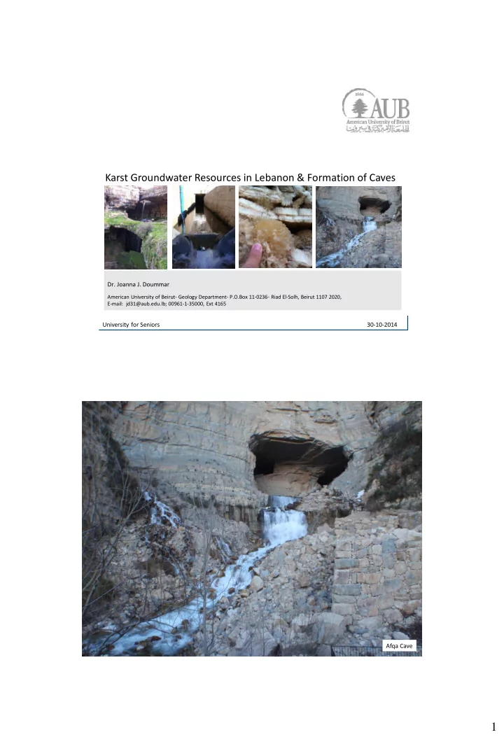
Karst Groundwater Resources in Lebanon & Formation of Caves
University for Seniors 30-10-2014 Afqa Cave
SLIDE 2 2
The amount of water on the earth’s surface:
- 95.96% Ocean water
- 2.97% Ice caps and glaciers
- 1.05% as Groundwater
- 0.009% as Lakes, rivers, and streams.
Importance of Groundwater Importance of Groundwater
- Groundwater is used as main resource in arid to semi arid regions, given the scarcity of
surface water.
- Drinking
- Domestic use
- Agricultural
- Industrial
e.g., Daily consumption (150 l/capita/day) Therefore it is important to
- Assess the availability of groundwater resources
- Ensure a sustainable protection against contamination.
SLIDE 3
3
The Water Cycle
Spring Precipitation
Infiltration Evaporation + Transpiration Surface runoff
Where does Groundwater come from? Catchment areas or GW basins
SLIDE 4
4
Evaporation + Transpiration Infiltration
Precipitation Where does Groundwater come from?
The Water Cycle Aquifers and Aquicludes
The different types of rocks can be considered aquifers or aquicludes depending on their permeability and porosity = ability to convey water.
SLIDE 5 5
Aquifers Aquifers
Aquifers are layers of highly permeable rocks/material with relatively high porosity that can store and transmit large quantities of ground water.
SLIDE 6 6
Fractured Aquifers
Porous aquifers like sand (water flow in between the grains in pores), whereas in fractured aquifers water flows in fractures and dissolved cracks highly heterogeneous and unpredictable
Groundwater outlets: Springs and wells
SPRINGS
- Springs: natural flow of groundwater and occur when water table intersect the earth’s
surface.
SLIDE 7 7
Groundwater: Springs and wells
WELLS
- When drilling water wells, if ground water rises naturally in a well above the level
where it was initially found, it is called artesian well.
- Artesian well can be found in a confined aquifer: aquifer overlain and underlain by two
aquicludes that keep water under pressure . Water will rise under its own pressure.
SLIDE 8 8
Groundwater: Springs and wells
WELLS
- When the water is pumped from a well, it produces a depression in the water
table known as cone of depression occurring around the well.
- Over-pumping causes depression in the water table at a large area; that
sometimes causes nearby wells to become dry.
SLIDE 9
9
Drawdown due to pumping
SLIDE 10 10
Geologic Work of Groundwater= Formation of Caves
- Karst is a term used to describe a special style of landscape containing caves and extensive underground
water systems that is developed on especially soluble rocks such as limestone, marble, and gypsum.
- Limestone is a sedimentary rock (composed of CaCO3),
- About 80 % of rock exposure in Lebanon are mostly limestone or dolostone.
SLIDE 11 11
Geologic Work of Groundwater= Formation of Caves
- The primary erosional work of groundwater is the dissolution of soluble rock such as
limestone, therefore responsible for the creation of caverns and other related features.
- Limestone (insoluble in pure water) can be dissolved by water containing weak carbonic
acid (H2CO3 ) as most natural water dissolves carbon dioxide from the air and from decaying plants.
SLIDE 12 12
Geologic Work of Groundwater
Water containing carbonic acid follows bedding planes, joints and dissolving limestone: The carbonic acid react with calcite to form calcium bicarbonate and calcium (a soluble material carried away in solution), forming limestone caverns. CO2 + H2O → H2CO3 CaCO3 + H2CO3 → 2(HCO3)- + Ca2+
Carbonic acid Lapiaz Karst Topography Karst Topography; an irregular terrain formed due to differential dissolution of calcite
- Different types of karst features:
SLIDE 13
13
Solution pits Rillen karren
SLIDE 14
14
Input Landforms: dolines
SLIDE 15
15
Baloua Baatara- Tannourine Dolines
SLIDE 16
16
SLIDE 17
17
Sinkhole in Florida
Leif Skoogfors/Woodfin Camp.
SLIDE 18
18
SLIDE 19
19
SLIDE 20 20
Geologic Work of Groundwater: Speleothems
In the vadose zone (unsaturated zone), calcite can precipitate again to form:
- Cave features: Speleothems e.g., Stalactites and Stalagmites
2(HCO3)- + Ca2+→ CaCO3 + H2O + CO2
Geologic Work of Groundwater
Speleothems: 2(HCO3)- + Ca2+→ CaCO3 + H2O+ + CO2
SLIDE 21
21
SLIDE 22 22
THE LONGEST CAVES OF LEBANON ( as of 2008, Speleo Club du Liban archives in m) 1 JIITA CAVE {10,050} 2 ROUEISS CAVE {5,460} 3 AFQA CAVE {5,260} 4 AL-KASSARAT CAVE {4,648} … 6 NABAA AL-SHATAWIE {4,130} THE DEEPEST CAVES IN LEBANON ( as of 2008, Speleo Club du Liban archives) 1 FAOUAR DARA SINKHOLE {-622} 2 QATTINE AZAR SINKHOLE {-515} 3 BALLOUH BAATARA SINKHOLE {-255} … 10 TARCHICH SINKHOLE {-147}
Caves of Lebanon
Groundwater Resources in Lebanon= Water Budget Precipitation (Snow and Rain; P) Evapotranspiration (ETP) Infiltration/Recharge (I) ∆𝑇 = 𝑄 − 𝐹𝑈𝑄 − 𝑆 − 𝐽 Flow in the subsurface Groundwater Surface runoff Rivers (R) 𝐽𝑜𝑔𝑚𝑝𝑥 − 𝑃𝑣𝑢𝑔𝑚𝑝𝑥 = ±∆𝑇
SLIDE 23 23
Water Budget= Precipitation in Lebanon Precipitation (including snow) = 800- 1800 mm/year; (UNDP, 1970), from coastal zones to high mountains. Snow is not measured in Lebanon. therefore there is a high uncertainty regarding the precipitation quantities Water Budget= Infiltration Main Aquifers in Lebanon= Karst aquifers Sandstone Basalt
SLIDE 24 24
Water Budget= Infiltration Main Aquifers in Lebanon= Karst aquifers Aquicludes: Impermeable Material Karst Aquifer: limestone Water Budget= Precipitation in Lebanon Infiltration to Groundwater (50-70% depending on the catchment especially high in fractured systems)
SLIDE 25 25
Water Budget= Groundwater outlet Springs: Jeita Spring Afqa Spring
High variability of discharge and fast response to rain event in karst spring
Water Budget= Groundwater outlet Springs: Jeita Spring
SLIDE 26 26
High variability of discharge; very low discharge in summer times
Water Budget= Groundwater outlet Anjar Spring Assal Spring Afqa Spring Laban Spring
SLIDE 27 27
Water Budget= Surface Runoff Rivers: mostly originating from springs Major rivers: Litani, Assi, and Hasbani Minor rivers: Nahr Ibrahim, Nahr El Kalb
Groundwater contamination
SLIDE 28 28
The composition of the raw water often requires processing in a waterworks prior distribution to the customer. Costly processing methods are involved, hydrogeology helps protecting groundwater at the source Problematic ingredients in raw water are:
- heavy metals Iron, Manganese
- rganic micropollutants (PPCP, Chlorinated Hydrocarbons)
- Microbial contaminants
- Heavy metals
- Other: Sodium Chloride, Potassium etc...
- Pharmaceuticals
Contamination of the Water at the source Treatment at the supply Microbial Pollution
Drinking water has to be microbiologically clean (0 CFU (Colonies) of Pathogens) Microorganisms can reach the groundwater when a protective soil cover is missing. Contamination from disposal of untreated waste water. E-coli
SLIDE 29
29
Petroleum products and heavy metals
Elevated heavy metal contents in water originating from recharge areas for Petroleum byproducts disposal
Pharmaceuticals:
Ibuprofen, Carbamazepine (below toxic limits), cocaine metabolites Varying concentration and Mass fluxes of Carbamazepine (pharmaceutical) in a spring with time
Agricultural contamination
Pesticides, insecticides and manure High levels of K+, Na+ and nitrates degradation of the soil quality and subsquently of Groundwater
SLIDE 30 30
Salt water Intrusion
High levels of salinities in many areas brakish water Allowed levels of Chlorides: 500 mg/l In wells in southern Beirut areas: e.g., maximum chloride concentration: 8733 mg/l
- due to extensive abstraction
Some Research Investigation related to Groundwater
Jeita: Delineation of catchment area: Tracer tests (funded by BGR: Federal Institute for Geoscience- Germany 2010-2012) Groundwater age on the Jeita catchment to know transit times of water in an aquifers (funded by AUB) Emerging pollutants in Lebanese springs (transport of pharmaceuticals in groundwater) Vulnerability studies: Identification of highly vulnerable zones for protection on two pilot areas (funded by USAID, PEER Science 2014-2017):
SLIDE 31
31
Jeita: Delineation of catchment areas
Identification of protection zones
SLIDE 32
32
Sampling for environmental tracers and stable isotopes Measurement of water levels in the springs and other chemical parameters
SLIDE 33
33
Thank you