
SLIDE 1
Middle-Snake-Tamarac Rivers Watershed District
Judicial Ditch #19 Watershed
Regional Conservation Partnership Program (RCPP) Public Scoping Meeting
September 26, 2016
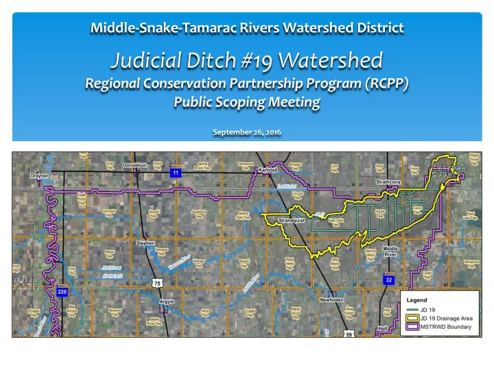
Will be modified map from GIS 6/16 EOD Judicial Ditch #19 - - PowerPoint PPT Presentation
Middle-Snake-Tamarac Rivers Watershed District Judicial Ditch #19 Watershed Regional Conservation Partnership Program (RCPP) Public Scoping Meeting September 26, 2016 Will be modified map from GIS 6/16 EOD Judicial Ditch #19 Watershed
September 26, 2016
1. Review Tamarac Project Work Team Progress 2. Overview - PL566 Planning process 3. Solicit Comments on the Resource Concerns 4. Inform Public of Future Steps
1. Review Tamarac Project Work Team Progress 2. Introduce Study Area 3. Public Law 566 Planning Process Overview 4. Watershed Setting and Resource Concerns 5. Overview of Next Steps 6. Questions/Public Comment Period
Middle-Snake-Tamarac Rivers Watershed District - 1,476 sq. mi. Tamarac River Watershed - 421 sq. mi.
Florian East Park Drainage Area (sq mi) 197.31 70.06 Storage Capacity (ac-ft) (ac-ft) inches (ac-ft) inches Sediment 125 0.012 71 0.019 Recreation 172 0.016 0.000 Wildlife 0.000 3329 0.891 Flood Water 800 0.076 4520 1.210 Total 1097 0.104 7920 2.121 Between High & Low Stages 379 0.036 2290 0.613 Surface Area (acres) (acres) (acres) Sediment 26 150 Recreation 50 Wildlife 1720 10 yr Freq Pool 76 2000 Design Freq Pool 104 2310 Volume of Fill (embankment) (cy) 35097 229584 Elevation Top of Dam (ft 1929 MSL) 929.1 1104.9 Max Height (ft) 31.6 14.9
Middle-Snake-Tamarac Rivers Watershed District - 1,476 sq. mi. Tamarac River Watershed - 421 sq. mi. Judicial Ditch #19 Watershed – 104 sq. mi.
Discuss purpose and need for project with sponsors/Initiate study.
Identify the need for the proposed action (quantify, extent, magnitude, timing, frequency etc.)
Write purpose and need statement and Write scope of plan-EA/EIS
Conduct detailed resource inventories and watershed assessment Economics, social effects, Archeological and historic resources Engineering/Geology/Support maps Document problems
Geology, Hydrology & Hydraulics, Cultural, Economics and Social
Develop reasonable alternatives, mitigation strategies and costs (Preliminary plans)
40 CFR 1506.6 – Public Involvement Primary Goal
Ensure all interested and affected parties are aware of the proposed action
(a) “make diligent efforts to involve the public in preparing and implementing their NEPA procedures.”
COST SHARE BREAKDOWN
Como Twp. Agriculture Field Flooding
Natural Resource Goals Middle-Snake-Tamarac Rivers Watershed 10-yr Plan (2011) Restore and protect unique ecological values and recreational opportunities within the district Maintain/improve water quality of rivers, streams, lakes, and groundwater resources. Protect wetlands and channels from sedimentation, and maintain the soil productivity of ag lands with the district Promote district goals to residents within the district as well as local, state, and federal agencies.
JD #19 Study Area – Public Land Resources JD #19 Study Area – Water Resources JD #19 Study Area – National Wetland Inventory
1-3 Months Plan of Work Develop Team Feasibility Report Define Concerns Public Meeting Field Survey Begin H&H 3-6 Months Purpose & Need Scope EA Field Survey Ex. H&H Modeling Field Inventory Begin Economics 6-12 Months Finalize Ex. H&H Without Project Conditions Economics: Preliminary Alternative Screening Preliminary Cultural Review 12+ Months Alternative Screening Geotech Impacted Lands Alternatives for Detailed Study H&H Alternatives Detailed Survey, Geotech, Design