
SLIDE 1
Planning the Future of
South Downtown
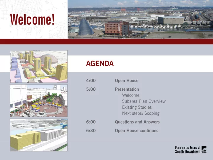
AgendA
4:00 Open House 5:00 Presentation Welcome Subarea Plan Overview Existing Studies Next steps: Scoping 6:00 Questions and Answers 6:30 Open House continues
Welcome! AgendA 4:00 Open House 5:00 Presentation Welcome - - PowerPoint PPT Presentation
Welcome! AgendA 4:00 Open House 5:00 Presentation Welcome Subarea Plan Overview Existing Studies Next steps: Scoping 6:00 Questions and Answers 6:30 Open House continues Planning the Future of South Downtown Project
Planning the Future of
South Downtown
AgendA
4:00 Open House 5:00 Presentation Welcome Subarea Plan Overview Existing Studies Next steps: Scoping 6:00 Questions and Answers 6:30 Open House continues
Planning the Future of
South Downtown
Foss Waterway *
dome district Brewery district
Nob Hill Hillside
University of Washington Tacoma
*The EIS will include properties owned by the Foss Waterway Development Authority.SOUTH dOWnTOWn SUBAreA InclUdeS:
dome district Brewery district University of Washington Tacoma Thea Foss Waterway
The plan acts as a catalyst for redevelopment and investment in the South downtown area. This plan will be accompanied by an environmental Impact Statement (eIS) that will provide a means to expedite environmental review of future development projects.
The city of Tacoma was awarded a grant from the Puget Sound regional council (PSrc) through their Sustainable communities Project to support neighborhood planning for more sustainable
South downtown Subarea.
Planning the Future of
South Downtown
The South downtown Subarea Plan and eIS will prepare the South downtown area for future development and growth
plans to create a comprehensive vision for the South downtown.
THe PlAn WIll:
Identify and prioritize necessary infrastructure improvements Plan for parks, trails and open space Prioritize transportation investments develop potential funding strategies Pre-approve up to 30 million square feet of new development space
Planning the Future of
South Downtown
2011 2012 2013
Scoping Period existing conditions report Preliminary goals and Policies draft Subarea Plan and draft eIS Implementation Final Subarea Plan, Final eIS and Final Policies
Planning the Future of
South Downtown
The State environmental Policy Act (SePA) requires agencies to undertake an assessment of the environmental effects of their proposed actions and possible mitigation measures prior to making decisions. The Subarea Plan will include an eIS to assess the probable environmental impacts of the Plan. Two major purposes of the SePA environmental review process are:
The following shows the key points within the SePA process.
Public Meeting and Minimum 30-day Comment Period
the issues and concerns identifjed during scoping.
documents the social and environmental effects analysis of the proposed action and alternatives, as well as potential mitigation measures.
Draft EIS FINAL EIS
15-day Notice
includes the response to comments on the draft EIS.
alternative.
City Council Decision
the requested action.
Notice of Intent and Public Scoping Period
Public Scoping Meeting and Minimum 30-day Comment Period
preparing an environmental impact statement (EIS).
public scoping/comment period.
Planning the Future of
South Downtown
dome district Brewery district
Nob Hill Hillside
University of Washington Tacoma
Foss Waterway *
*The EIS will include properties owned by the Foss Waterway Development Authority.
Planning the Future of
South Downtown
Conceptual illustration of the maximum build out allowed in the Dome District. Maximum building height of 120-225 feet with a minimum density of 30 units per acre. Minimal to no
integrated, mixed use, 24-hour neighborhood. Conceptual illustration of the maximum build out allowed in the Brewery District. Maximum building height of 100 feet with urban density levels. Minimal to no setbacks.
Brewery District Dome District
Conceptual illustration of the maximum build out allowed in the Hillside Neighborhood. Maximum building height of 90 feet with urban density levels. Minimal to no setbacks.
Hillside Neighborhood in the Brewery District
Planning the Future of
South Downtown
Conceptual illustration of the maximum build out allowed in the Nob Hill Neighborhood. Maximum building height of 60 feet with medium residential density levels. 15 foot setbacks in the front and back, with 5 foot setbacks on the side. Requirement for 10% yard. Conceptual illustration of the maximum build out allowed
Tacoma campus. Maximum building height of 100 feet with urban density levels. Minimal to no setbacks.
University of Washington Tacoma Nob Hill Neighborhood in the Brewery District
Conceptual illustration of the maximum build out allowed along the Thea Foss Waterway. Maximum building height of 65-180 feet, with setbacks consistent with Tacoma’s Shoreline Master Program. Illustration shows an integrated neighborhood supporting residential, commercial and water oriented uses.
Foss Waterway
Planning the Future of
South Downtown
Attend the public scoping meeting
date: Thursday, december 15, 2011 location: University of Washington Tacoma carwein Auditorium Keystone Building, room 102 Time: 4:00 – 7:00 pm
Provide written comments via mail
Ian Munce city of Tacoma community and economic development 747 Market Street, room 1036 Tacoma, WA 98402
Provide comments via email
planning@cityoftacoma.org
The scoping period for the Subarea Plan eIS will begin on december 5, 2011 and last until January 10, 2012. during this period, the public can comment on what should be included in the eIS.
How to provide comments during the scoping period: