
SLIDE 1
Water & Courtesy F. Phillips and S. Mills Salt Inputs/ Cyclic - - PowerPoint PPT Presentation
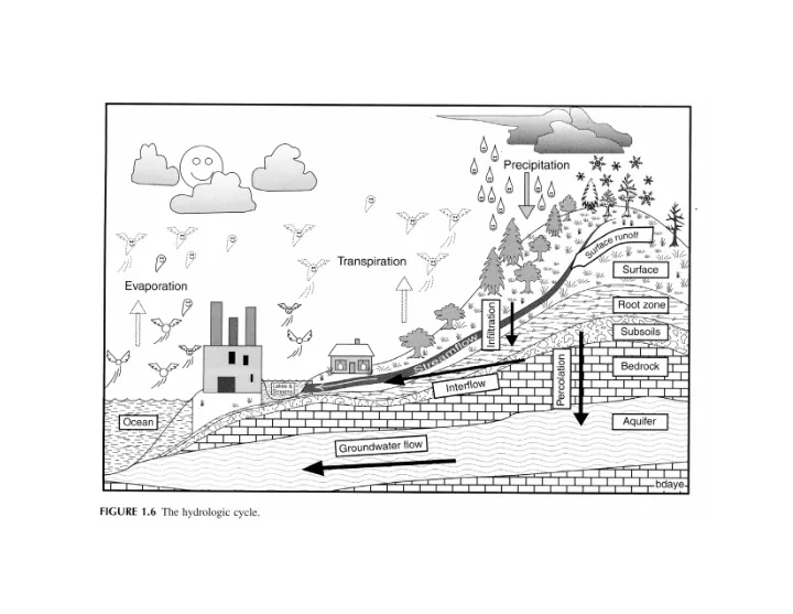
Water & Courtesy F. Phillips and S. Mills Salt Inputs/ Cyclic salts and Riparian Weathering Outputs Transpiration Open Water Evaporation Consumptive Agricultural use Evapotranspiration Waste water Geothermal waters Saline
Cyclic salts and Weathering Saline Groundwaters Geothermal waters Waste water
Riparian Transpiration Agricultural Evapotranspiration Open Water Evaporation Consumptive use
Courtesy F. Phillips and S. Mills
R iver flow ir r igation pr e c ipitation
Gro undwa te r re c ha rg e a nd disc ha rg e
West E a s t dr ain L F CC R io Gr ande Well pumping tr anspir ation e vapor ation L F CC gain
Gro undwa te r
r ec har ge and disc har ge
Groundwater Outflow Riparian ET Crop ET Open Water Evap M&I Depletion
Ma g da le na Mo unta ins
N
So c o rro Sa n Anto nio
60
380
Sa n Ac a c ia
I-25
Sa n Ma rc ia l Rio Gra nde
Re g io na l mo de l - I SC T e le sc o pic mo de l
Legend
No Sample Clay, Sandy Clay Silt, Silt & Fine Sand Fine Sand Fine to Medium Sand, Medium Sand Fine to Coarse Sand, Coarse Sand Sand and Gravel, Gravel Clayey Gravel Santa Fe Group Bedrock Water Surface
400 ft 20 ft
HWY-W02 HWY-E01HWY-E02
HWY-E03
East Rio Grande
4560 4540 4520 4500 4480 4460
HWY-W06 HWY-W03 HWY-W04 LFCC HWY-W07
Valley alluvium Santa F e F
mation L ayer 3 L ayer 2 L ayer 1
West
Stratigraphy
0.5 mile s no rth o f Hig hwa y 380 in Sa n Anto nio So c o rro Rive rside Dra in L F C C Rio Gra nde
Legend
Well 0-20 feet Well 40-50 feet Well 80-90 feet Staff gage Extraction well
10 07 09
L F CC R io Gr ande
Low-permeability zone
T ime -dra wdo wn o f ne ste d we ll W07A,B,C r o f W07 = 15 fe e t
0.2 0.4 0.6 0.8 1 1.2 1.4 1.6 1.8 0.01 0.1 1 10 100 1000 10000
Elapsed Time (min) Drawdown (ft)
Legend
Well 0-20 feet Well 40-50 feet Well 80-90 feet
L F CC R io Gr ande
Low-permeability zone
L a ye r 1 - sa nd
0 fe e t 35 fe e t
L a ye r 3 - sa nd/ g ra ve l
0 fe e t 75 fe e t
L a ye r 2 - c la y/ silt
Model boundary
San Antonio Ditch Luis Lopez Drain Luis Lopez Ditch Rio Grande Socorro Riverside Drain Socorro Main Canal Mosley Lateral Apodaca Lateral LFCC 1 Mile
N
Str eam –aquifer System R epr esentation of Str eam –aquifer System
Rive r Surfa c e Wa te r T a b le Stre a mb e d Rive r Sta g e (HRI V) I mpe rme a b le Wa lls M W RBOT
Rive rb e d Co nduc ta nc e = K L W M
MODF L OW Rive r Pa c ka g e :
L OW 83) L a nd Surfa c e He a d in Ce ll (h)
Gage reading at San Marcial Stage height input for model
0.00 0.50 1.00 1.50 2.00 Oct Dec Jan Mar May Jul Sep Nov Jan Mar May Jul
Stage (feet)
8.1 8.3 8.5 8.7 8.9 9.1 9.3 9.5 9.7 9.9
R ipar ian Cr
Legend
Crop and pasture Riparian Sandbars Other or inactive
I K ONOS – July 2000
r egional model
Co nsta nt he a d b o unda ry de te rmine d fro m re g io na l mo de l fo r e ve ry stre ss pe rio d
telesc opic model
IN af/yr River seepage 34,037 Net boundary influx 6,052 TOTAL IN 40,089 OUT LFCC seepage 31,930 Evapotranspiration 8,191 TOTAL OUT 40,121 IN - OUT
4535 4540 4545 4550 4555 4560 4565 4570 4575 4535 4545 4555 4565 4575
Observed Heads (ft amsl) Simulated Heads (ft amsl)
10 - 25 ft 40 - 70 ft R2=0.97 RMS = 5.22 ft Screen Depth
Gro undwa te r Budg e t