
SLIDE 1
Rye Civic League “Water in Rye” 2017
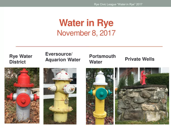
Water in Rye
November 8, 2017
Private Wells Eversource/ Aquarion Water Rye Water District Portsmouth Water
Water in Rye November 8, 2017 Eversource/ Rye Water Portsmouth - - PowerPoint PPT Presentation
Rye Civic League Water in Rye 2017 Water in Rye November 8, 2017 Eversource/ Rye Water Portsmouth Private Wells Aquarion Water District Water Table of Contents 2 Who are the Water Suppliers Rye is intricately tied to water
Rye Civic League “Water in Rye” 2017
Private Wells Eversource/ Aquarion Water Rye Water District Portsmouth Water
2
Table of Contents
Rye Water District Aquarion / Eversourse Portsmouth Water Private Wells
Storm Water Run Off Bacteria Landfills
Rye is intricately tied to water resources of many kinds. We have the ocean, 2,649 acres of Open Wetlands, 441 acres of water, surrounded by development, and a very productive aquifer. Our quality of life and health depends on these resources. We take a look at the public water supplies, their protection
to our water resources.
3
Rye Water Suppliers
Portsmouth Water
4
Portsmouth Water provided in Rye
5
Rye Water District
Your Water Bill: You are billed in two parts for RWD, usage (a base annual service fee) and a tax. Annual Service fee for first 50,000 gallons of water. Most homes average 4,167 gallons per month. Larger meter allows for more water usage without a drop in water
Overage fees are for 1,000 gallons
the standard is 748 gallons or 100 cubic feet. Increasing cost by water units. Also taxed at a rate of $0.386 per $1,000. So if your house is assessed at $500,000 that would be $193 per year to RWD, plus your usage bill.
RWD is run by Town Meeting by those who live in the Water
are the first Wednesday of the month 9:00am 60 Sagamore Rd.
6
Rye Water District Spending Plans from the Draft CIP
RWD 2017 annual budget is $1.3 million One truck was replaced. RWD owns three vehicles Garland Rd. Pump House needs refurbishing New Waterline for Harbor Road New Well Investigation: 2016 Drought, continued developments and accessory dwelling units Replacement of another truck in 2019 Rt 1B Wentworth Rd. New pipe if a fixed bridge is installed. Note: Water Treatment plan has been in past CIP documents, but is not included now. About $250,000 has already been spent on a design that focused on iron and manganese removal, if the State or contamination require the water to be chlorinated. PFOA would be a different design to incorporate these.
7
Eversource – Aquarion in Rye Aquarion serves 691customers in the Rye Beach and Jenness Beach Districts. Jenness Beach customers are partially served by Well 5A on Central Road. Rye Beach customers are served by wells in Hampton and North Hampton
Well 5A
8
Eversource – Aquarion in Rye
9
Eversourse – Aquarion Water
Water is billed at: $4.536 per 100 Cubic feet (748 gallons) Annual Service charge based on meter (see table) Click Here for full document:. Aquarion PCF Water Testing Data Click Here
Size of Meter Annual Fee 5/8 Inchn 187 $ 3/4 Inch 281 $ 1 inch 468 $ 1 1/2 inch 937 $ 2 inch 1,498 $ 3 inch 2,808 $ 4 inch 4,680 $ 6 inch 9,360 $ 8 inch 14,976 $ 10 inch 21,528 $
10
Portsmouth Water
NH 1899 Session Law granted Portsmouth the authority to supply Newington, Greenland, New Castle and parts of Rye with water services. 79 Rye homes directly served by Portsmouth Water . They pay $4.17/unit (748 gallons) for the first 10 units of use in a monthly billing cycle (7,480 gallons) and $5.00/unit for anything over that. Portsmouth sells (wholesales) water to the Rye Water District
Summer usage : 300,000 gallons per day Wholesale rates were flat for 27 years and recently went up. Current wholesale rate is $3.35 per unit (1 unit = 748 gallons of water). Annual RWD fees for Portsmouth water are higher, but there is no tax assessment. Overage rate is higher and there is less water per billing unit.
Cap colors are different on Portsmouth Fire Hydrants – they follow this standard Blue : >1500 gallons per minute Green: 1000 to 1499 gallons per minute Orange: 500 to 999 gallons per minute Red : <499 gallons per minute
11
Private Wells
NH DES Rules for Private Wells Click Here State Water Testing Brochure: Click Here NH DES Drinking Water fact sheets: Click Here NH DES Video on containments: Click Here NH DES Suggested Testing is not updated for PFCs: Click Here
More information will be provided during the Hydrology section
12
Rye Sewer Department
12 1989 Agreement with Hampton Rye Beach Jenness Beach Public Sewer In 1992,under a consent decree with the EPA, a public sewer was installed in portions of the Rye Beach and Jenness Beach Village Districts (see map). 547 parcels are on the Sewer. The sewer system connects to Hampton’s under a long term contract, that is due for renewal. Rye contributes to capital costs. Residents are billed by the Rye Sewer Commission as follows. All department costs are covered by user feeds: Sewer rate is : .055 cents per cubic feet of H2O Consumption Hook-up Fee: Front Footage Charge $242.35/per foot 50 Foot Front (minimum charge) $12,117.50 100 Foot Front $24,235.00 170 Foot Front (maximum charge) $41,199.50 Portsmouth Sewer: The Adams Trailer Park gets RWD water and is connected to the Portsmouth Sewer, Rye Sewer is the administrator Atlantic Grill is connected to the Portsmouth Sewer and future development could also be connected. Facts: 6.9 Miles of Sewer 3 pumping stations, that are maintained by Hampton Sewer
13
Rye Sand and Gravel Aquifer
NH DES Ground Water protection fact sheet: Click Here
14
Rye Hydrology
Provided by: Danna B. Truslow, CG, PGTruslow Resource Consulting LLC www.truslowRC.com
R – Recharge to Groundwater D – Discharge to wetlands and surface water
Bedrock Bedrock Sand and Gravel
R R D D D R Wetlands, Rivers, Ponds, or Lakes
In sand and gravel, groundwater flow is similar to land contours.
Sand and Gravel Aquifer Wetland Stream Aquifer: Highest Transmissivity
Winter et al. 1998
Wetlands, ponds, rivers
15
Rye Hydrology
Provided by: Danna B. Truslow, CG, PGTruslow Resource Consulting LLC www.truslowRC.com
unconsolidated materials (gravel, sand, or silt) from which groundwater can be extracted using a water well.
High Transmissivity Low Transmissivity
Well- Sorted Material (ex. Sand and gravel aquifer) Bedrock Poorly-Sorted Material (ex. Glacial till, hardpan)
Low or Localized Transmissivity
16
Rye Hydrology
Provided by: Danna B. Truslow, CG, PGTruslow Resource Consulting LLC www.truslowRC.com
Water flows through pores between grains
transmissivity
agriculture
–
Dug well
–
Driven well point
–
Sensitive to water level change
–
Vulnerable to surface contamination
–
Usually <20’ deep
municipal or commercial
–
Gravel pack increases transmissivity
–
Less sensitive to seasonal changes or drought
–
Deeper wells for more storage and yield
sand and gravel surface saturated Fractured bedrock
RWD Garland and Aquarion Well 5A are these type of wells. RWD blends Garland with the two bedrock wells.
17
Rye Hydrology
Provided by: Danna B. Truslow, CG, PGTruslow Resource Consulting LLC www.truslowRC.com
Groundwater flows to wells via fracture zones – lower transmissivity
Private homeowner wells
Larger community supply wells
Fractured Bedrock Overburden Community Supply Wells Private Homeowner Wells RWD Bailey Brook Well and Cedar Run are this type. These wells put higher levels of iron (Fe) and maganese (Mn) – tints the water red. Blending with the Garland Well masks this.
18
Aquifer Protection Zones : Wells and Risks
Town of Rye GIS System with annotations Blue = well; Green = Sanitary radius; Red outline – Protection Zone Gray since this protection zone did not exist and there is development in this Sanitary zone
19
Local Landfills & Public Wells
1.24 mi
1,610 ft
1.1mi
Breakfast Hill Landfill Coakley Landfill Grove Rd Landfill Rye Dump
1.53mi
Garland Well RWD Bailey Brook Well Aquarion Well 5A
1,150 ft
20
Aquifer Protection Zones : Aquifer, Wells and Risks
Town of Rye GIS System with annotations: Red circles landfills/dump; Red is the aquifer protection Blue is Transmissivity, the darker, the easier it is for water to move in this area.
21
What Impacts Our Water Supplies – Impervious surfaces
From NH DES November 2016 Presentation
During rain storms and snow melt, water running off of impervious surfaces carries pollutants and sediments into streams, lakes, and estuaries. To keep waters clean, impervious surfaces should be a low percentage of the total amount of land areas of the watershed basin. NHDES recommends no more
than 10% impervious cover for a town (or watershed). Above this, we see water quality starting to decline!!!!
Impervious Surfaces are anything that prevents water flowing straight down into the ground. So paved parking lots, patios, roadways, roofs, etc….
22
What Impacts Our Water Supplies
From NH DES November 2016 Presentation
36.7% of Rye is open wetlands or water As of 2010 Rye already had 15.5%
impervious, causing runoff. No 2017 update on where we are and how to track this.
Rye
“severe degradation expected beyond 25% impervious cover”
Source: Click Here
23
What Impacts Our Water Supplies - Wetland Buffers Question: Do we know the percentage of wetland buffers already compromised (septic systems, buildings, driveways….)?
Property Wetlands Wetlands Buffer
Wetlands Buffers protect property from flooding. They also protect leach fields and other non-natural substances from being saturated and pulled back into the wetlands Wetlands Buffers filter and protect the water supply from non-natural and waste.
24
Rye Polluting our waters
Rye Hot Spots for pollution: Enterococci is what is tested
considered a health hazard by NHDES PC 07, PC08, BCH11 Parson’s Road area PC-Out Parson’s Creek
Septic sniffing dogs confirmed human contamination, so it can’t be said its all animal waste.
25
Rye Polluting our waters – 2016 Sampling Data actions to date
A septic pump out and reporting ordinance took effect in 2016 To date of the +650 septic systems in the watershed 257 have been pumped out and “inspected” with a report to the town. All must be inspected and pumped out by June 2019
letters in 2016 offering assistance. Only one of the recipients has replied to date and was inspected with no issues. Dog waste removal was added to town ordinances in 2017 The 2016 Parsons Creek Committee was not renewed in 2017
26
Rye Polluting our waters – 2017 Sampling Data
What does the 2017 testing tell us? 76 Data points, just over ½ (39 points are greater than 104 col/100 mL) 10 were 1,000 or more We still have a very high level of pollution that is not going away unless more is done.
DRY WET DRY WET Pre-Storm Pre-Storm Storm Storm Post-Storm DRY WET 6/26/17 7/25/17 7/28/17 8/24/17 9/5/17 9/6/17 9/7/17 9/8/17 9/11/17 9/21/17 10/10/17 ACPS005-U15 216 75 3,873 743 97 ACPS005-U35 108 1,010 250 145 52 350 96 AwcominMarsh 110 313 10 31 97 86 BCH08 52 63 10 20 52 52 538 185 41 146 10 BCH11 1,120 2,600 211 465 51 826 17,329 110 86 573 373 HarborRoad 389 1,660 30 350 529 1,090 OF-EelPond 20 120 187 201 31 62 PC07 185 323 <10 86 108 121 3,448 75 31 110 246 PC08 146 1,470 20 31 41 74 1,989 52 <10 10 121 PC-OUT 52 299 10 121 97 295 4,611 457 63 388 233 ID
27
Monitoring PFC
From NH DES November 2017 Presentation
28
RCL Annotated TOWN OF RYE Berry Brook Wetlands and Soils Map here Berry Brook extends from the Breakfast Hill Coakley Landfills area through Rye to Ordiorne 1 Coakley Landfill 2 Breakfast Hill Landfill 3 Grove Road Landfill 4 Rye Recycling DPW Green shading poorly drained soils and wetlands
29
Grove Road Landfill
Landfill is located 50 ft. above and approximately 1110 feet from the Rye Water District Garland Well . This gravel and sand well is the most productive well and offsets the iron and manganese from the two bedrock wells.
30
Grove Road Landfill
Road pretty much open 24/7
highway department.
system which was estimated at $900K due to decomposed trash detected in groundwater
monitoring wells at the Grove Road Dump and between 14-21 in the Garland Well
31
Town Recycling, DPW, Salt Shed and Brush Dump
Located approximately 1650 feet from the Garland Well 44 feet upgrade at the Salt Shed (proposed to be replaced on 2018 Warrant Town vehicle gas station on the property Pesticides and other lawn chemicals from private properties are deposited at the brush dump Bulk trash bins are not water tight. Cars at the transfer station: Any leaks run down the pavement to the catch basin Buildings are in dire need of repair, but redesign and significant repairs are not on the current Capital Improvement Plan Prioritized Improvements 1. Salt Shed to allow completely indoor salt handling, swale to retain any run off to surround 2. New fueling location on the level with concrete pad 3. Vehicle washing system with recycle/retention of soapy water and dirt/salt
32
Breakfast Hill Landfill – Impacts to Rye Breakfast Hill Road:
take the Pease Waste to Energy Ash along with Jones Road landfill in Portsmouth.
Problems:
PFOA and PFOS.
Next Steps:
and private wells.
33
Coakley Landfill – Impacts to Rye
Coakley Landfill History: 1. Licensed ”landfill” between 1971 and 1985. 2. Everything and anything went in the “landfill” between late 1960s and 1982. 3. Between 1982 and 1985 took Pease Waste to Energy Ash – now 50 foot layer of ash on top of waste. 4. “Responsible Parties” means 78 which dumped hazardous waste from off-site locations. Responsible parties are listed click here: The parties include the Air Force and the US Navy (20% combined). The remaining 80%, or Coakley Landfill Group (CLF) is comprised of: a) The city of Portsmouth (54%), b) The town of North Hampton, c) The town of Newington, d) A variety of other private parties. 5. Capped in 1994. NO liner underneath. Problems now:
Note: Aquarion is looking at adding a well and so is Rye Water District
34
Moving Forward – What is happening
Current Status (Coakley, Grove Road and Breakfast Hill Landfills): 1. The Task Force is now a Commission and regular meetings are held in Concord. The Commission wants to keep the meetings in Concord. 2. NHDES said that remediation is necessary to stop contamination of Berry’s Brook. 3. EPA issued an addendum to their report at our last Task Force Meeting which said no public health threat from Coakley. 4. Task Force and NHDES disagree with EPA. 5. EPA is having a public meeting on 11/15 in North Hampton. Next Steps: 1. Tell your friends and neighbors that EPA is wrong and get as many friends and family to come to the 11/15 EPA meeting. 2. Advocate with your friends, relatives and representatives to make EPA admit it is not acceptable to contaminate our surface water. 3. Come to Rye Water/Board of Selectmen and Rep. Messmer meeting in late November (TBA). 4. Advocate for Rye water to install water treatment system on Rye water to protect health of public especially children. 5. Advocate for Grove Road and Breakfast Hill Road Landfills to be cleaned up. 6. Join New Hampshire Safe Water Alliance on Facebook to keep in touch with developments.
35
Discussions Moving Forward in Rye
Water consumption: Winter (gallons) Summer (gallons) Rye Water 300,000 per day 850,000 per day Portsmouth 6,000 per day 300,000 per day Rye Water District new well: $5 million – will take four to five years If a Rye Water Treatment plan is needed: $6m to $7m – will take four to five years Storm Water/Impervious surfaces:
Parsons Creek: What is an acceptable pace to correct the pollution? PFOA: Assuming these are a health hazard, what can be done. Have that conversation now, not once action is forced. Does the Transfer Station present a water quality risk? Actions from slide 33
The Rye Civic League publishes the monthly Rye Civic News. You can add yourself to the Rye Civic News distribution e-mail list at www.ryecivicleague.org The Rye Civic League consists of Rye residents who volunteer our time. Please feel free to get involved and help residents be educated and informed. We meet the last Wednesday of the month in the Rye Public Library at 6:30pm When the RCL meeting ends, there is a Public Forum that is attended by very knowledgeable residents in Rye. So, this is a chance to have an open discussion about what is on your mind or to ask questions.
36