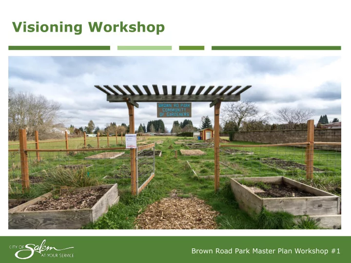
Visioning Workshop Brown Road Park Master Plan Workshop #1 Agenda - - PowerPoint PPT Presentation

visioning workshop
SMART_READER_LITE
LIVE PREVIEW

Visioning Workshop Brown Road Park Master Plan Workshop #1 Agenda - - PowerPoint PPT Presentation

Visioning Workshop Brown Road Park Master Plan Workshop #1 Agenda for Tonight Staff Presentation Introduction Master Plan Process Planning Context Virtual Field Trip Site Analysis Question & Answer


slide-1
SLIDE 1

Visioning Workshop

Brown Road Park Master Plan Workshop #1

slide-2
SLIDE 2

Agenda for Tonight

2

  • Staff Presentation
  • Introduction
  • Master Plan Process
  • Planning Context
  • Virtual Field Trip
  • Site Analysis
  • Question & Answer Session

Five Minute Break

  • Yard Sale Activity
  • Announcement of Next Workshop Date – May 22, 2018, 6:30 p.m.
  • Adjournment

Brown Road Park Master Plan Workshop #1

slide-3
SLIDE 3

3

Master Plan Process

Step 1: Site Assessment Step 2: Outreach and Master Plan Development Step 3: Adoption Process

North Lancaster Neighborhood Association (NOLA) Salem Parks and Recreation Advisory Board

Public Hearing

City Council Adoption

 Understand Opportunities and Issues  Evaluate Site Characteristics  Identify Stakeholders

Workshop #1 Visioning Workshop #2 Design Alternatives Workshop #3 Preferred Alternative Draft Master Plan Report

Brown Road Park Master Plan Workshop #1

slide-4
SLIDE 4

4 Planning Context

Vicinity Map

slide-5
SLIDE 5

5

Site History

Planning Context

1978

Identified as a potential park site

1996

Purchased by City

2000-2001

Early master planning (not adopted)

2013

Phase 1 Predevelopment

  • Community garden
  • Trails
  • Parking lot

2014

Phase 2 Predevelopment

  • Tree planting
  • Additional irrigation work

2016

Phase 3 Predevelopment

  • Seeded open field
  • Additional irrigation work
slide-6
SLIDE 6

6

Early Draft Master Plan

Planning Context

slide-7
SLIDE 7

Neighborhood Demographic

7 Planning Context ETHNIC BACKGROUND AGE DISTRIBUTION

2010 Census

  • Total population was 5,105
  • Roughly 6,134 people per sq. mile

(Citywide is 3,145 people per sq. mile) 2012-2016 ACS estimates

  • Roughly 17% of households were

limited English-speaking

Hispanic and Latino (any race) White African American Native American Asian Pacific Islander Other under 5 5 to 9 10 to 14 15 to 19 20 to 24 25 to 34 35 to 44 45 to 54 55 to 59 60 to 64 65 to 74 75 to 84 85 and

  • lder
slide-8
SLIDE 8

NOLA Goals

8 Planning Context

Brown Road Park master planning goals approved by NOLA: Goal 1: Park design and equipment should showcase unique attributes to distinguish the character and diversity of the NOLA neighborhood. Goal 2: Park design shall incorporate amenities and facility attributes as identified for a neighborhood park in the [Comprehensive Park System] Master Plan with a focus on health and family. Park design should maintain an exception for a parking lot. Goal 3: Park design should enhance visibility into the park space from adjacent local streets and residences. Goal 4: Park design should enhance safety of the users of the park. Goal 5: Promote tree planting to increase the urban tree canopy of the North Lancaster Neighborhood and extend the community garden

  • f the park.
slide-9
SLIDE 9

Related Plans

9 Planning Context

Comprehensive Park System Master Plan

  • Defines park classifications
  • Prioritizes the master planning and

development of Brown Road Park

  • Guidelines on the types of faculties in a

neighborhood parks

Sensitive Area Management Handbook

  • Identifies sensitive features in the park
  • Wetlands
  • Forested area
  • Describes management practices for

maintenance

slide-10
SLIDE 10

Standard Facilities

10 Planning Context

 Picnic area  Site furnishings (trash receptacles, bike rack, pet waste station, etc.)  Playground or play features  Walking paths  Including ADA-compliant perimeter paths or sidewalks  Open turf area  Trees  On-street parking (Off-street parking)  Park identification sign  Security Lighting  One of the “Optional Facilities” (Community Garden)

      

slide-11
SLIDE 11

Optional Facilities

11 Planning Context

 Practice sports fields  Sports courts  Other active recreation facilities  Skate spot  Horseshoe pits  Bocce court  Adult fitness equipment  Disc golf hole  Community garden  Multi-use trails  Soft-surface trails  Shelter, shade structure, or gazebo  Lighting  Seasonal chemical toilet

 

Adult fitness equipment

slide-12
SLIDE 12

Not Appropriate

12 Planning Context

 Dog park  On-site parking / parking lot (Exception)  BMX/mountain bike trails  Aquatic facilities  Splash fountains  Pools  Destination facilities or resources with community-wide draw  Memorials (except for memorial trees or benches)  Floral plantings (e.g. rose gardens)  Reservable facilities

slide-13
SLIDE 13

13 Virtual Field Trip | Aerial Overview

slide-14
SLIDE 14

14 Virtual Field Trip | Street Improvements

slide-15
SLIDE 15

15 Virtual Field Trip | Site Photo

LOCATION FINDER

slide-16
SLIDE 16

16 Virtual Field Trip | Site Photo

LOCATION FINDER

slide-17
SLIDE 17

17 Virtual Field Trip | Site Photo

LOCATION FINDER

slide-18
SLIDE 18

18 Virtual Field Trip | Site Photo

LOCATION FINDER

slide-19
SLIDE 19

19 Virtual Field Trip | Site Photo

LOCATION FINDER

slide-20
SLIDE 20

20 Virtual Field Trip | Existing Amenities

slide-21
SLIDE 21

21 Virtual Field Trip | Wetlands

slide-22
SLIDE 22

22 Virtual Field Trip | Site Photo

LOCATION FINDER

slide-23
SLIDE 23

23 Virtual Field Trip | Site Photo

LOCATION FINDER

slide-24
SLIDE 24

24 Site Analysis Summary

Opportunities & Constraints

Opportunities:

  • Provide a range of park facilities
  • Increase tree canopy
  • Create a community destination/gathering area
  • Increase close-to-home recreation resources
  • Develop a plan that appeals to may users

Constraints

  • Isolated site
  • Traffic / buffer from road
  • Wetlands
  • Creating nuisances / impacts to neighbors
  • Pedestrian access (until street improvements are completed)
slide-25
SLIDE 25

Share your vision!

Online survey open through April 24th

English: http://bit.ly/cosbrownroad-b Spanish: http://bit.ly/cosbrownroad-s

slide-26
SLIDE 26

Q & A

slide-27
SLIDE 27

Yard Sale Activity

  • Spending Exercise: Everyone gets $27.70 in stickers
  • Prioritize park facilities and uses by “shopping”
  • Something missing? Feel free to add to the list
  • Talk with the project team and ask questions
slide-28
SLIDE 28

Would like a table le with h ches ess s board rd bocce ce ball l court rt Write in comments Add items

slide-29
SLIDE 29

Thank you for attending

Remember to take the online survey! Next workshop is May 22, 2018 at 6:30 p.m.

Park webpage: www.cityofsalem.net/brown-road-park Email updates: To receive project updates, make sure to provide your email address at the sign-in table. Staff contact: Rob Romanek, Parks Planner Public Works Department (503) 588-6211 rromanek@cityofsalem.net English: http://bit.ly/cosbrownroad-b Spanish: http://bit.ly/cosbrownroad-s