
SLIDE 1
Viewing the Physical Environment through the five Guiding - - PowerPoint PPT Presentation
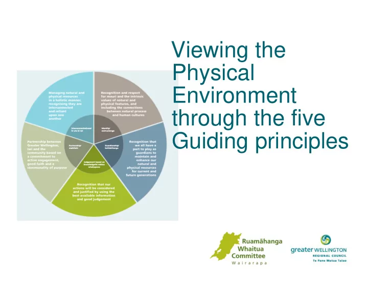
Viewing the Physical Environment through the five Guiding principles Identity | wairua Landscape character and identity is formed from peoples connection to places, the way they use and relate to place . How does peoples use of the
Landscape character and identity is formed from people’s connection to places, the way they use and relate to place. How does people’s use of the river, streams and lakes shape
How do we see our rivers? – the river as nature- the river as resource | sustenance- the river as a tonic for health and wellbeing- the river as our identity. How do wetlands shape our identity?
Crassula Ruamahanga Caspian Tern
are vulnerable - now and in the future?
management and health of the rivers and wider whaitua?
Many organisations share similar objectives and commitments to protect, maintain water quality and healthy rivers. How do we work collectively and share resources to achieve the best outcome for the Ruamāhanga whaitua?
influence each other?
East of the Ruamahanga River
Shallow and porous soils of soft mudstone, sandstone and limestone that are prone to erosion. The soils & low rainfall 700-800mm pa = more prone to drought and limited land use opportunities. Low rainfall = low river flows and greater flow variability Soils are made of smaller particles that are light and mobile have a naturally high turbidity.
West of the Ruamahanga River
High fertile soils- Yellow Brown, silt and stone loam soils. High annual rainfall
High land use versatility, intensive farming and orchards. High rainfall = high base flow and less flow variability in the seasons. Generally have clearer water because high flow and the particles are larger and heavy.
European settlement.
intergeneration knowledge, science to inform decision making
Rivers are much more than just bodies of water. ‘The mana, wairua or mauri of the river should not be seen as separate from all the things that relate to the river, including the tributaries, land catchment area, or silt once deposited on what is now dry land’