
SLIDE 1
2018 Stormwater Master Plan
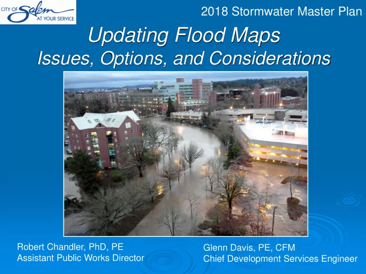
Updating Flood Maps
Issues, Options, and Considerations
Robert Chandler, PhD, PE Assistant Public Works Director Glenn Davis, PE, CFM Chief Development Services Engineer
Updating Flood Maps Issues, Options, and Considerations Robert - - PowerPoint PPT Presentation
2018 Stormwater Master Plan Updating Flood Maps Issues, Options, and Considerations Robert Chandler, PhD, PE Glenn Davis, PE, CFM Assistant Public Works Director Chief Development Services Engineer 2018 Stormwater Master Plan National Flood
2018 Stormwater Master Plan
Updating Flood Maps
Issues, Options, and Considerations
Robert Chandler, PhD, PE Assistant Public Works Director Glenn Davis, PE, CFM Chief Development Services Engineer
2018 Stormwater Master Plan
National Flood Insurance Program
Establishes minimum requirements Adopts Flood Insurance Rate Maps (FIRMs) 2 Floodplain Floodway
2018 Stormwater Master Plan
The Regulated Floodplain Flood Insurance Rate Maps
3
2018 Stormwater Master Plan
Stormwater Master Planning
Purpose: To identify projects, programs, and policies that:
(1)
Reduce risks related to flooding, and
(2)
Mitigate the adverse impacts
environment.
4
2018 Stormwater Master Plan
Stormwater Master Planning
Analyses: Evaluate the impacts of stormwater runoff under both current and future development conditions.
Rainfall, land use, soils, topography, stream gage, surveys, flood photos, etc.
Compare model output to actual events
Test scenarios, compare
5
2018 Stormwater Master Plan
6
Waln Creek
Stormwater Master Plan (Analysis)
2018 Stormwater Master Plan
7
Stormwater Master Plan (Analysis)
2018 Stormwater Master Plan
Issue: Given we have improved data and modeling methods, Should we use the data and modeling to produce new Flood Insurance Rate Maps?
8
Three considerations….
2018 Stormwater Master Plan
Consideration #1
Current Floodplain Maps are Flawed
9
Glenn Creek Floodplain Floodway Glenn Creek Glenn Creek
2018 Stormwater Master Plan
10
Consideration #2
Impacts to development & property owners
Note: For discussion purposes only. This is entirely a hypothetical scenario.
2018 Stormwater Master Plan
Consideration #2
Impacts to development & property owners
11
Note: For discussion purposes only. This is entirely a hypothetical scenario.
2018 Stormwater Master Plan
Consideration #2
Impacts to development & property owners
12
Note: For discussion purposes only. This is entirely a hypothetical scenario.
2018 Stormwater Master Plan
13
Note: For discussion purposes only. This is entirely a hypothetical scenario.
Consideration #3
FEMA Rules for Determining the Floodplain
2018 Stormwater Master Plan
14
Note: For discussion purposes only. This is entirely a hypothetical scenario.
Consideration #3
FEMA Rules for Determining the Floodplain
2018 Stormwater Master Plan
Options
Redefining the Floodplain
15
Publish Stormwater Master Plan (incl. 100-year inundation) Wait for FEMA to update
Regulate as Interim until FEMA adopts maps Submit to FEMA for adoption
Regulate as Interim until FEMA updates maps Submit to FEMA for information only
2018 Stormwater Master Plan
Recommendation
The data and modeling methods developed for the Stormwater Master Plan should be used to update the floodplain maps in Salem.
if embankments should be credited for reducing risks of flooding.
Flood Hazard Areas and will be regulated as such by the City.
notified of locally promulgated floodplains.
by FEMA.
16
2018 Stormwater Master Plan
How could this affect you?
[Once the analysis is completed]
You will remain in the floodplain
Existing floodplains are unaffected by the City-produced maps
You might be placed in the floodplain
You may be required to obtain flood insurance The value of your property might be affected
the floodplain:
You will know whether the property is in the floodplain
17
2018 Stormwater Master Plan
18