Technical Advisory Committee Meeting Nov. 27th 2014 Watershed - - PowerPoint PPT Presentation

technical advisory committee meeting
SMART_READER_LITE
LIVE PREVIEW

Technical Advisory Committee Meeting Nov. 27th 2014 Watershed - - PowerPoint PPT Presentation

Drinking Water and Watershed Protection Technical Advisory Committee Meeting Nov. 27th 2014 Watershed Updating & Streamlining Partnerships Requirements Discussion with First for Water for Nations Subdivision Community Regional


slide-1
SLIDE 1

Drinking Water and Watershed Protection – Technical Advisory Committee Meeting
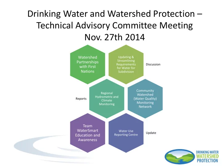
  • Nov. 27th 2014

Updating & Streamlining Requirements for Water for Subdivision Discussion

Watershed Partnerships with First Nations

Regional Hydrometric and Climate Monitoring Reports

Community Watershed (Water Quality) Monitoring Network

Water Use Reporting Centre Update

Team WaterSmart Education and Awareness

slide-2
SLIDE 2

CORRESPONDANCE

  • Letter from MOTI Approving Officer,

Kirsten Fagervik

  • Strengthening requirements for water

provision for subdivision

  • Why? To avoid parcels created with

insufficient water over the long term & to minimize cumulative impacts on the water source

  • Consistency between agencies → RDN

(Subdivision Bylaw 500)and MOTI requirements

  • Establish required components (standards
  • f practice) for groundwater reports as a

part of development applications

Updating & Streamlining Requirements for Water for Subdivision

Program Action 3: Land Planning and Development

slide-3
SLIDE 3

DISCUSSION

Potential Updates:

  • Meets the Canadian Drinking Water

Guidelines for potable water

  • Specified pump testing requirements and

consistent required volume per day between MOTI and RDN

  • Water must be proven on every lot; not

sufficient to use well records from neighbouring pptys as proof of water

  • Demonstrates no adverse impacts on

surrounding wells, groundwater resources, receiving waters, as determined through a professional hydrogeological assessment within appropriate radius

Updating & Streamlining Requirements for Water for Subdivision

Program Action 3: Land Planning and Development

slide-4
SLIDE 4

Objectives:  To protect drinking water through the Regional Growth Strategy, OCP policies and designations, and zoning bylaws.  To ensure that new development provides proof of adequate and sustainable, good quality drinking water.  To ensure that new development minimizes impacts on surface and groundwater resources.  To prioritize and develop long-term management plans for watersheds.

Goal: To use the information gathered through Program 2 to protect the Region's watersheds and water resources in land use planning and development decisions.

PROGRAM ACTION 3 Land Planning and Development

DISCUSSION

slide-5
SLIDE 5

Objectives:  To protect drinking water through the Regional Growth Strategy, OCP policies and designations, and zoning bylaws.  To ensure that new development provides proof of adequate and sustainable, good quality drinking water.  To ensure that new development minimizes impacts on surface and groundwater resources.  To prioritize and develop long-term management plans for watersheds.

PROGRAM ACTION 3 Land Planning and Development

slide-6
SLIDE 6

3A: LID Standards 3B: Development Application Review 3C: Development Charges 3D: Planning Tools Upcoming work for 2015 +

  • Guidance on where to start /

focus

  • Key considerations

PROGRAM ACTION 3 – LAND PLANNING AND DEVELOPMENT

slide-7
SLIDE 7

REPORTS

Regional Hydrometric and Climate Monitoring

Program Action 2: Water Resources Inventory & Monitoring

slide-8
SLIDE 8

Regional District of Nanaimo – Drinking Water and Watershed Protection

Regional Hydrometric and Climate Monitoring Scoping Study

slide-9
SLIDE 9

November 27, 2014

9

Climate and Hydrometric Monitoring – Scoping Study

Scoping Study Goals and Objectives Scope Review of Existing Climate and Hydrometric Monitoring Network List of Program Objectives and Ranking Criteria Data standards Introduction to hydrometric/climate monitoring stations and costs Next steps

Outline

slide-10
SLIDE 10

November 27, 2014

10

Drinking Water and Watershed Protection Action Plan

Goal: Improve information about the Region’s water resources in terms of both quality and quantity, in support of better land use decisions and public understanding. Objectives: 1. Inventory existing climate and water monitoring sites 2. Improve stream monitoring for water level, flow and temperature. 3. Improve groundwater monitoring 4. Catalogue and distribute data in consistent user-friendly format. Data Gap identified in Water Budget Study

Water Resource Inventory and Monitoring Program #2

slide-11
SLIDE 11

November 27, 2014

11

Regional Hydrometric and Climate Monitoring

1. Summarize existing climate and hydrometric network 2. Review Program Goals and Objectives 3. Framework and Criteria for Ranking Potential Monitoring Sites 4. Recommend hydrometric and climate data standards 5. Recommend data catalogue and distribution system 6. Ranked list of recommended sites 7. Implementation Plan including costs for installation, maintenance and training 8. Identify potential stakeholders and partnerships in on-going maintenance of program.

Scoping Study Scope

slide-12
SLIDE 12

November 27, 2014

12

Regional Hydrometric and Climate Monitoring

Existing Hydrometric and Climate Monitoring

Agency Data Collected Number of Active Stations Water Survey of Canada Water Level, Stream Flow 8 Department of Fisheries and Oceans Water Level, Stream Flow 3 BC Conservation Foundation Water Level, Stream Flow 8 Environment Canada Climate Data/Marine 8 MFLNRO Climate Data 5 MFLNRO Snow Data 2 School Monitoring Network Climate Data 17 MoTI Climate Data 1 Community Watershed Monitoring Water Quality 50

slide-13
SLIDE 13

November 27, 2014

13

Regional District of Nanaimo - Stations

slide-14
SLIDE 14

November 27, 2014

14

Regional Hydrometric and Climate Monitoring

a) General Water/Climate Information/Public Awareness b) Water Resource Management -- Allocations & Operations c) Watershed Health Tracking d) Interpreting Water Quality Data and Groundwater Data e) Low Flow/Conservation Flow Monitoring f) Planning for impacts of Climate Change: Flood and Water Availability Forecasting g) Regional Water Availability Studies h) Land Use Decisions i) River Engineering and Drainage Design j) Others? WHY? ….. Climate/Network Data Objectives from Stakeholders

slide-15
SLIDE 15

November 27, 2014

15

Water Survey of Canada

  • Min. of Forests Lands Natural Resource Operations
  • Min. of Environment

BC Conservation Foundation Municipal Water Purveyors Regional District of Nanaimo Vancouver Island University Forestry Industry – Timber West & Island Timberlands

Partners / Stakeholders

Regional Hydrometric and Climate Monitoring

slide-16
SLIDE 16

November 27, 2014

16

Regional Hydrometric and Climate Monitoring

1. Existing Station? 2. Discontinued Station Location vs. Brand new site location 3. Specific Purpose vs. General Purpose 4. Natural vs. Regulated Watershed 5. Geophysical Characterization (Coastal Lowlands vs Mountain) 6. Watershed Size or Climate Station Density 7. Tie into Ground Water Monitoring Program 8. Site Access and Land Tenure

Potential Ranking Criteria

slide-17
SLIDE 17

November 27, 2014

17

Regional Hydrometric and Climate Monitoring

Data Standards – Resource Information Standards Committee

Data Grade Description Water Level Accuracy Discharge Accuracy Grade A* Highest Level. Similar to National WSC

  • Standard. Requires “perfect” field

conditions to achieve. < +/- 2 mm < +/- 7% Grade B Same operational techniques with allowance for more difficult field conditions. < +/- 5 mm < +/- 15% Grade C Manually operated sites. Less rigorous procedure for rating curve. < +/- 1 cm <+/- 25% * Grade A also includes Grade A R/S for rated structures (weirs, etc.)

Developed by MoE Science and Information Branch - 2009 Station set-up and data quality guidelines

slide-18
SLIDE 18

November 27, 2014

18

Regional Hydrometric and Climate Monitoring

1. World Meteorological Organization Standards 2. Environment Canada Standards 3. Forest Weather Network Standards (MFLNRO) 4. RISC – Snow Pillow Standards

Climate Station Standards

slide-19
SLIDE 19

November 27, 2014

19

Hydrometric Site Layout

Hydrometric Monitoring

1. Select location with stable channel 2. Develop Rating Curve (Water Level vs Flow Relationship) 1. Measure Water Level 2. Calculate Flow using Rating Curve 3. Update Rating Curve as necessary

slide-20
SLIDE 20

November 27, 2014

20

Regional Hydrometric and Climate Monitoring

1. Automatic vs Manual 2. Telemetry for real time data? 3. Continuous vs. Spot measurements

Site Considerations Costs

Hydrometric Stations – Install cost $10,000 to $20,000 Maintenance $8,000 to $15,000 per year Climate Station – Install cost $5,000 to $10,000 Maintenance Costs – depends on location Snow Pillow - Install cost $30,000 to $40,000 Maintenance cost $10,000 to $15,000 per year Spot Flow Measurements – costs for training (volunteers) ~$550, equipment purchase $$ or rental ~$175/day

slide-21
SLIDE 21

November 27, 2014

21

Regional Hydrometric and Climate Monitoring

1. Refine Goals/Objectives 2. Refine ranking criteria 3. Site Ranking 4. Implementation plan/costs 5. Identification of potential stakeholders and partners Draft Report Prior to End of 2014

Next Steps

slide-22
SLIDE 22

November 27, 2014

22

Regional Hydrometric and Climate Monitoring

Thank you Contact: Craig Sutherland Kerr Wood Leidal Associates Ltd. 250-595-4223

slide-23
SLIDE 23

REPORTS

  • 3-Year Trend Report, MOE
  • Analyze water quality data

from sample periods in 2011 – 2013

  • Covers the data collected

by 5 stewardship groups

  • Has helped inform

monitoring in 2014

Community Watershed (Water Quality) Monitoring Network

Program Action 2: Water Resources Inventory & Monitoring

slide-24
SLIDE 24
slide-25
SLIDE 25

UPDATES

  • BC WURC - purpose is to serve as a secure

interface to store demand (and supply) data to help improve water budget calculations and inform water allocation decisions

  • Regional /basin-wide view of water use
  • Track trends over time, produce reports easily
  • Implemented in 2014 for RDN municipal water

purveyors – thank you for data input!

  • Plan to roll-out to Improvement Districts and
  • ther large users in the RDN spring 2015

Water Use Reporting Centre

Program Action 5: Water Use Management Program Action 2: Water Resources Inventory & Monitoring

slide-26
SLIDE 26

cubic meters (m3) CITY OF NANAIMO All water usage 2008 - 2014

slide-27
SLIDE 27

TOWN OF QUALICUM BEACH All water usage 2012 - 2014 cubic meters (m3)

slide-28
SLIDE 28

DISTRICT OF LANTZVILLE All water usage 2010 - 2014 cubic meters (m3)

slide-29
SLIDE 29

ARROWSMITH WATER SERVICE All water usage 2008 - 2014 cubic meters (m3)

slide-30
SLIDE 30

CITY OF PARKSVILLE All water usage 2012 - 2014 cubic meters (m3)

slide-31
SLIDE 31

RDN Nanoose Bay Peninsula All water usage 2010 - 2014 cubic meters (m3)

slide-32
SLIDE 32

RDN Englishman River All water usage 2010 - 2014 cubic meters (m3)

slide-33
SLIDE 33

RDN French Creek All water usage 2010 - 2014 cubic meters (m3)

slide-34
SLIDE 34

Monthly Comparative Metrics:

  • Utility Water Usage – this year

and last year + YTD

  • Comparison with other Utility in

the Region

  • Water Storage % (surface water)
  • Groundwater Levels
  • Precipitation – this month this

year and last year + YTD

  • Temperature – Today’s Temp vs.

avg / max/ min for the month

  • Evapotranspiration - current vs

average

  • Drought Level
  • Snowpack
slide-35
SLIDE 35

UPDATES

  • New development: the BC WURC will have capacity to house /

display hydrometric data (non- WSC sites included) thanks to Okanagan BWB

  • The Province of BC (MOE and MFLNRO) has expressed interest in

exploring BC WURC as a provincial reporting tool to fit within the new Water Sustainability Act.

Water Use Reporting Centre

Program Action 5: Water Use Management Program Action 2: Water Resources Inventory & Monitoring

slide-36
SLIDE 36

UPDATES

  • School Field Trips
  • Rebate Programs
  • Irrigation Check-up Stats
  • Graphical Water Billing

Feedback

Team WaterSmart Education and Awareness

Program Action 1: Public Awareness and Involvement

slide-37
SLIDE 37

School Watershed Field Trips

  • “The pre-trip activities package was excellent. Students were

well-prepared for the experience. Student response to the experience was very positive overall. THANK YOU!” – Mrs. Creighton, Departure Bay School, Gr. 4

slide-38
SLIDE 38

Rural Water Quality Stewardship Program 2014

BEFORE AFTER BEFORE AFTER

slide-39
SLIDE 39

Rural Water Quality Stewardship Program 2014

BEFORE AFTER BEFORE AFTER

slide-40
SLIDE 40

Rural Water Quality Stewardship Program 2014

5 10 15 20 25 30 35 A B C E F G H Nanaimo Lantzville Parksville QB

Rural Water Quality Stewardship Program Rebates by Type & Area

# of tests # of upgrades

slide-41
SLIDE 41

Rainwater Harvesting Incentive Program 2014

slide-42
SLIDE 42

Residential Irrigation Check-ups UPDATES

slide-43
SLIDE 43

Residential Irrigation Check-ups (2013)

slide-44
SLIDE 44

UPDATES

Residential Irrigation Check-ups (2013)

slide-45
SLIDE 45

Graphical Water Billing Reports

slide-46
SLIDE 46

WATERSHED PARTNERSHIPS SESSION at Nanoose First Nation and the Englishman River

  • Sept. 26, 2014
slide-47
SLIDE 47

Other updates, comments from committee members?

Thank You! …for your feedback and guidance as we work together for our water