SLIDE 1
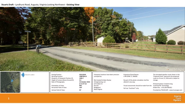
Viewpoint locations have been precision surveyed by: Rick Casteel & Adam Bosley I3 Engineering, LLC 527 E Main St Ste 102 Bridgeport West Virginia Projection/Zone/Datum: UTM ZONE 17, NAD83 No part of this photo simulation shall be altered in any way. Visual assessments should be made from the full size TrueView™ only. The simulated pipeline route shown in the ‘Proposed View’ represents the proposed route as of June 15, 2016 and is subject to change. Photosimulation Created Using TrueViewTM Technology (Patent No.: US 8,184,906 B2) Provided by:TRUESCAPE - www.truescape.com
1
Stuarts Draft - Lyndhurst Road, Augusta, Virginia Looking Northwest - Existing View
Easting Position: 2221539.8 Northing Position: 13807815.0 Elevation of Viewpoint Position (f): 1430.7 Height of Camera Above Ground (f): 5.4 Date of Photography: 12-October-2015 at 11:37 am Orientation of View: NW Horizontal Field of View: 124° Vertical Field of View: 55°
SLIDE 2
Viewpoint locations have been precision surveyed by: Rick Casteel & Adam Bosley I3 Engineering, LLC 527 E Main St Ste 102 Bridgeport West Virginia Projection/Zone/Datum: UTM ZONE 17, NAD83 No part of this photo simulation shall be altered in any way. Visual assessments should be made from the full size TrueView™ only. The simulated pipeline route shown in the ‘Proposed View’ represents the proposed route as of June 15, 2016 and is subject to change. Photosimulation Created Using TrueViewTM Technology (Patent No.: US 8,184,906 B2) Provided by:TRUESCAPE - www.truescape.com
2
Stuarts Draft - Lyndhurst Road, Augusta, Virginia Looking Northwest - Proposed View
Easting Position: 2221539.8 Northing Position: 13807815.0 Elevation of Viewpoint Position (f): 1430.7 Height of Camera Above Ground (f): 5.4 Date of Photography: 12-October-2015 at 11:37 am Orientation of View: NW Horizontal Field of View: 124° Vertical Field of View: 55°
SLIDE 3
Viewpoint locations have been precision surveyed by: Rick Casteel & Adam Bosley I3 Engineering, LLC 527 E Main St Ste 102 Bridgeport West Virginia Projection/Zone/Datum: UTM ZONE 17, NAD83 No part of this photo simulation shall be altered in any way. Visual assessments should be made from the full size TrueView™ only. The simulated pipeline route shown in the ‘Proposed View’ represents the proposed route as of June 15, 2016 and is subject to change. Photosimulation Created Using TrueViewTM Technology (Patent No.: US 8,184,906 B2) Provided by:TRUESCAPE - www.truescape.com
3
Devil’s Knob Lookout - Devil’s Knob Loop, Nelson, Virginia Looking South - Existing View
Easting Position: 2229251.1 Northing Position: 113774276.5 Elevation of Viewpoint Position (f): 3729.1 Height of Camera Above ground (f): 5.4 Date of Photography: 05-November- 2015 at 2:50 pm Orientation of View: S Horizontal Field of View: 124° Vertical Field of View: 55°
SLIDE 4
Viewpoint locations have been precision surveyed by: Rick Casteel & Adam Bosley I3 Engineering, LLC 527 E Main St Ste 102 Bridgeport West Virginia Projection/Zone/Datum: UTM ZONE 17, NAD83 No part of this photo simulation shall be altered in any way. Visual assessments should be made from the full size TrueView™ only. The simulated pipeline route shown in the ‘Proposed View’ represents the proposed route as of June 15, 2016 and is subject to change. Photosimulation Created Using TrueViewTM Technology (Patent No.: US 8,184,906 B2) Provided by:TRUESCAPE - www.truescape.com
4
Devil’s Knob Lookout - Devil’s Knob Loop, Nelson, Virginia Looking South - Proposed View
Easting Position: 2229251.1 Northing Position: 113774276.5 Elevation of Viewpoint Position (f): 3729.1 Height of Camera Above ground (f): 5.4 Date of Photography: 05-November- 2015 at 2:50 pm Orientation of View: S Horizontal Field of View: 124° Vertical Field of View: 55°
SLIDE 5
Viewpoint locations have been precision surveyed by: Rick Casteel & Adam Bosley I3 Engineering, LLC 527 E Main St Ste 102 Bridgeport West Virginia Projection/Zone/Datum: UTM ZONE 17, NAD83 No part of this photo simulation shall be altered in any way. Visual assessments should be made from the full size TrueView™ only. The simulated pipeline route shown in the ‘Proposed View’ represents the proposed route as of June 15, 2016 and is subject to change. Photosimulation Created Using TrueViewTM Technology (Patent No.: US 8,184,906 B2) Provided by:TRUESCAPE - www.truescape.com
5
Beech Grove Road 01 - Beech Grove Road, Nelson, Virginia Looking Southeast - Existing View
Easting Position: 2225251.1 Northing Position: 13770298.1 Elevation of Viewpoint Position (f): 2129.8 Height of Camera Above ground (f): 5.4 Date of Photography: 05-November- 2015 at 4:22 pm Orientation of View: SE Horizontal Field of View: 124° Vertical Field of View: 55°
SLIDE 6
Viewpoint locations have been precision surveyed by: Rick Casteel & Adam Bosley I3 Engineering, LLC 527 E Main St Ste 102 Bridgeport West Virginia Projection/Zone/Datum: UTM ZONE 17, NAD83 No part of this photo simulation shall be altered in any way. Visual assessments should be made from the full size TrueView™ only. The simulated pipeline route shown in the ‘Proposed View’ represents the proposed route as of June 15, 2016 and is subject to change. Photosimulation Created Using TrueViewTM Technology (Patent No.: US 8,184,906 B2) Provided by:TRUESCAPE - www.truescape.com
6
Easting Position: 2225251.1 Northing Position: 13770298.1 Elevation of Viewpoint Position (f): 2129.8 Height of Camera Above ground (f): 5.4 Date of Photography: 05-November- 2015 at 4:22 pm Orientation of View: SE Horizontal Field of View: 124° Vertical Field of View: 55°
Beech Grove Road 01 - Beech Grove Road, Nelson, Virginia Looking Southeast - Proposed View
SLIDE 7
Viewpoint locations have been precision surveyed by: Rick Casteel & Adam Bosley I3 Engineering, LLC 527 E Main St Ste 102 Bridgeport West Virginia Projection/Zone/Datum: UTM ZONE 17, NAD83 No part of this photo simulation shall be altered in any way. Visual assessments should be made from the full size TrueView™ only. The simulated pipeline route shown in the ‘Proposed View’ represents the proposed route as of June 15, 2016 and is subject to change. Photosimulation Created Using TrueViewTM Technology (Patent No.: US 8,184,906 B2) Provided by:TRUESCAPE - www.truescape.com
7
Wintergreen Entrance - Beech Grove Road, Nelson, Virginia Looking North-Northwest - Existing View
Easting Position: 2225751.8 Northing Position: 13769273.5 Elevation of Viewpoint Position (f): 1921.7 Height of Camera Above ground (f): 5.4 Date of Photography: 05-November- 2015 at 4:49 pm Orientation of View: NNW Horizontal Field of View: 124° Vertical Field of View: 55°
SLIDE 8
Viewpoint locations have been precision surveyed by: Rick Casteel & Adam Bosley I3 Engineering, LLC 527 E Main St Ste 102 Bridgeport West Virginia Projection/Zone/Datum: UTM ZONE 17, NAD83 No part of this photo simulation shall be altered in any way. Visual assessments should be made from the full size TrueView™ only. The simulated pipeline route shown in the ‘Proposed View’ represents the proposed route as of June 15, 2016 and is subject to change. Photosimulation Created Using TrueViewTM Technology (Patent No.: US 8,184,906 B2) Provided by:TRUESCAPE - www.truescape.com
8
Easting Position: 2225751.8 Northing Position: 13769273.5 Elevation of Viewpoint Position (f): 1921.7 Height of Camera Above ground (f): 5.4 Date of Photography: 05-November- 2015 at 4:49 pm Orientation of View: NNW Horizontal Field of View: 124° Vertical Field of View: 55°
Wintergreen Entrance - Beech Grove Road, Nelson, Virginia Looking North-Northwest - Proposed View
SLIDE 9
Viewpoint locations have been precision surveyed by: Rick Casteel & Adam Bosley I3 Engineering, LLC 527 E Main St Ste 102 Bridgeport West Virginia Projection/Zone/Datum: UTM ZONE 17, NAD83 No part of this photo simulation shall be altered in any way. Visual assessments should be made from the full size TrueView™ only. The simulated pipeline route shown in the ‘Proposed View’ represents the proposed route as of June 15, 2016 and is subject to change. Photosimulation Created Using TrueViewTM Technology (Patent No.: US 8,184,906 B2) Provided by:TRUESCAPE - www.truescape.com
9
Beech Grove Road 02 - Beech Grove Road, Nelson, Virginia Looking North - Existing View
Easting Position: 2225505.6 Northing Position: 13768905.4 Elevation of Viewpoint Position (f): 1867.35 Height of Camera Above Water (f): 5.4 Date of Photography: 14-October-2015 at 3:43 pm Orientation of View: N Horizontal Field of View: 124° Vertical Field of View: 55°
SLIDE 10
Viewpoint locations have been precision surveyed by: Rick Casteel & Adam Bosley I3 Engineering, LLC 527 E Main St Ste 102 Bridgeport West Virginia Projection/Zone/Datum: UTM ZONE 17, NAD83 No part of this photo simulation shall be altered in any way. Visual assessments should be made from the full size TrueView™ only. The simulated pipeline route shown in the ‘Proposed View’ represents the proposed route as of June 15, 2016 and is subject to change. Photosimulation Created Using TrueViewTM Technology (Patent No.: US 8,184,906 B2) Provided by:TRUESCAPE - www.truescape.com
10
Beech Grove Road 02 - Beech Grove Road, Nelson, Virginia Looking North – Proposed During Construction View
Easting Position: 2225505.6 Northing Position: 13768905.4 Elevation of Viewpoint Position (f): 1867.35 Height of Camera Above Water (f): 5.4 Date of Photography: 14-October-2015 at 3:43 pm Orientation of View: N Horizontal Field of View: 124° Vertical Field of View: 55°
SLIDE 11
Viewpoint locations have been precision surveyed by: Rick Casteel & Adam Bosley I3 Engineering, LLC 527 E Main St Ste 102 Bridgeport West Virginia Projection/Zone/Datum: UTM ZONE 17, NAD83 No part of this photo simulation shall be altered in any way. Visual assessments should be made from the full size TrueView™ only. The simulated pipeline route shown in the ‘Proposed View’ represents the proposed route as of June 15, 2016 and is subject to change. Photosimulation Created Using TrueViewTM Technology (Patent No.: US 8,184,906 B2) Provided by:TRUESCAPE - www.truescape.com
11
Beech Grove Road 02 - Beech Grove Road, Nelson, Virginia Looking North – Proposed View
Easting Position: 2225505.6 Northing Position: 13768905.4 Elevation of Viewpoint Position (f): 1867.35 Height of Camera Above Water (f): 5.4 Date of Photography: 14-October-2015 at 3:43 pm Orientation of View: N Horizontal Field of View: 124° Vertical Field of View: 55°
SLIDE 12
Viewpoint locations have been precision surveyed by: Rick Casteel & Adam Bosley I3 Engineering, LLC 527 E Main St Ste 102 Bridgeport West Virginia Projection/Zone/Datum: UTM ZONE 17, NAD83 No part of this photo simulation shall be altered in any way. Visual assessments should be made from the full size TrueView™ only. The simulated pipeline route shown in the ‘Proposed View’ represents the proposed route as of June 15, 2016 and is subject to change. Photosimulation Created Using TrueViewTM Technology (Patent No.: US 8,184,906 B2) Provided by:TRUESCAPE - www.truescape.com
12
Selma - Campground Road, Johnston, North Carolina Looking North-Northwest - Existing View
Easting Position: 2459279.0 Northing Position: 12911271.3 Elevation of Viewpoint Position (f): 169.3 Height of Camera Above Ground (f): 5.4 Date of Photography: 15-October-2015 at 12:56 pm Orientation of View: NNW Horizontal Field of View: 124° Vertical Field of View: 55°
SLIDE 13
Viewpoint locations have been precision surveyed by: Rick Casteel & Adam Bosley I3 Engineering, LLC 527 E Main St Ste 102 Bridgeport West Virginia Projection/Zone/Datum: UTM ZONE 17, NAD83 No part of this photo simulation shall be altered in any way. Visual assessments should be made from the full size TrueView™ only. The simulated pipeline route shown in the ‘Proposed View’ represents the proposed route as of June 15, 2016 and is subject to change. Photosimulation Created Using TrueViewTM Technology (Patent No.: US 8,184,906 B2) Provided by:TRUESCAPE - www.truescape.com
13
Selma - Campground Road, Johnston, North Carolina Looking North-Northwest – Proposed During Construction View
Easting Position: 2459279.0 Northing Position: 12911271.3 Elevation of Viewpoint Position (f): 169.3 Height of Camera Above Ground (f): 5.4 Date of Photography: 15-October-2015 at 12:56 pm Orientation of View: NNW Horizontal Field of View: 124° Vertical Field of View: 55°
SLIDE 14
Viewpoint locations have been precision surveyed by: Rick Casteel & Adam Bosley I3 Engineering, LLC 527 E Main St Ste 102 Bridgeport West Virginia Projection/Zone/Datum: UTM ZONE 17, NAD83 No part of this photo simulation shall be altered in any way. Visual assessments should be made from the full size TrueView™ only. The simulated pipeline route shown in the ‘Proposed View’ represents the proposed route as of June 15, 2016 and is subject to change. Photosimulation Created Using TrueViewTM Technology (Patent No.: US 8,184,906 B2) Provided by:TRUESCAPE - www.truescape.com
14
Selma - Campground Road, Johnston, North Carolina Looking North-Northwest – Proposed View
Easting Position: 2459279.0 Northing Position: 12911271.3 Elevation of Viewpoint Position (f): 169.3 Height of Camera Above Ground (f): 5.4 Date of Photography: 15-October-2015 at 12:56 pm Orientation of View: NNW Horizontal Field of View: 124° Vertical Field of View: 55°