Source: Connected Water, Commonwealth Government Surface Water - - PowerPoint PPT Presentation

source connected water commonwealth government surface
SMART_READER_LITE
LIVE PREVIEW

Source: Connected Water, Commonwealth Government Surface Water - - PowerPoint PPT Presentation

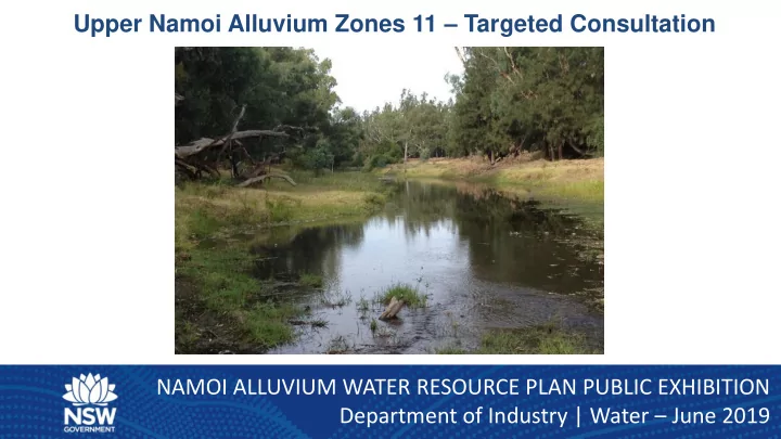
Upper Namoi Alluvium Zones 11 Targeted Consultation NAMOI ALLUVIUM WATER RESOURCE PLAN PUBLIC EXHIBITION Department of Industry | Water June 2019 Source: Connected Water, Commonwealth Government Surface Water Groundwater Interaction


slide-1
SLIDE 1

Upper Namoi Alluvium Zones 11 – Targeted Consultation NAMOI ALLUVIUM WATER RESOURCE PLAN PUBLIC EXHIBITION Department of Industry | Water – June 2019

slide-2
SLIDE 2

Surface Water – Groundwater Interaction

Source: Connected Water, Commonwealth Government

slide-3
SLIDE 3

Mechanisms for impact:

  • 1. Reduction in baseflow
  • 2. Increase in losses
  • 3. Reversal of baseflow to

losses The magnitude and timing of impacts variable according to:

  • 1. Total extracted volume
  • 2. Rates of extraction
  • 3. Distance of bore from river

Source: Connected Water, Commonwealth Government

slide-4
SLIDE 4

Rainfall Residual Mass

Rainfall Residual Mass

slide-5
SLIDE 5

Upper Namoi Zone 11

slide-6
SLIDE 6

Hydrograph – Maules Creek Rd

slide-7
SLIDE 7

Hydrograph – Therribri Rd

slide-8
SLIDE 8

Hydrograph – Elfin Crossing

slide-9
SLIDE 9

Hydrograph – Green Gully

slide-10
SLIDE 10

Hydrograph – Thornfield Crossing

slide-11
SLIDE 11

Comparison of Groundwater and Surface Water Levels with Average Rainfall

GW967137 Pipe 1 Screens: 8 – 11 m

Cease to Flow Height

slide-12
SLIDE 12

Upper Namoi Zone 11

  • Independent research by the University of New South Wales shows:
  • Monitoring bores upstream of Elfin Crossing show significant connection/

influence from surface water

Upstream of Elfin Crossing Maules Creek is gaining Downstream of Elfin Crossing Maules Creek losing Adjacent to Elfin Crossing There is a series of perennial or near-perennial pools

slide-13
SLIDE 13

Prior temporary water restrictions in Zone 11

  • Temporary water restrictions on groundwater pumping applied from 2007-

2010 under section 323 of the WMA 2000 (replaced by section 324 in 2009).

  • Applied to 15 licence holders - restricted groundwater pumping from

groundwater bores (other than domestic and stock bores) as follows:

  • When surface flows in Maules Creek (Elfin Crossing) were less than 1

ML/day - pumping was limited to 12 hours/day.

  • Flows ceased in Maules Creek - pumping restricted to 4 hours/day.
slide-14
SLIDE 14

More recent concerns in Zone 11

  • Concern regarding the equity in access to the surface

water and groundwater resources between all water users, including:

  • Users of the pool at Elfin Crossing,
  • landholders with basic rights,
  • Irrigators, and
  • Near-by coal mines (through indirect inflow)
slide-15
SLIDE 15

Surface Water / Groundwater Connectivity Macro Approach

Water sharing plans (WSP) that commenced post 2009 included a method to assess surface water - groundwater (SW-GW) connectivity categories. Three criteria for determining areas of high hydraulic connectivity: a) Average width of the groundwater source of no more than 4 km b) Average saturated thickness of no more than 30 m c) Sufficiently shallow water table in the groundwater source to be connected to the associated surface water.

slide-16
SLIDE 16

Surface Water / Groundwater Connectivity Macro Approach

Where considered ‘Highly connected’; the principles are used to specify which types of management rules used to manage the SW-GW connectivity:

  • 1. ‘Highly connected’ classified as - where 70% or more of the groundwater extracted is from

surface water within an irrigation season. All other systems are considered ‘less highly connected’.

  • 2. Highly connected alluvial systems within a regulated river system - link Available Water

Determinations (AWDs) for the groundwater to the AWDs for the surface water.

  • 3. Highly connected alluvial systems within perennial unregulated systems - daily access

rules linking their management to the associated unregulated surface water daily access rules. Non-perennial systems will have groundwater only rules.

slide-17
SLIDE 17

Stream Depletion from Groundwater Pumping

10 20 30 40 50 60 70 80 90 100 1 2 3 4 5 6 7 8 9 10 11 12 13 14 15 16 17 18 19 20 21 22 23 24 25 26 27 28 29 30 31 32 33 34 35 36 37 % Loss from the River Time (months)

Variable Distance from River Aquifer (K =9.5 m/day, Sy =0.012, B = 15 m)]

100 200 300 400 500 600 800

If 70% impact on the river is the triggered then surface ater rules after: <4 weeks at 100 m 5 weeks at 200 m 11 weeks at 300 m 5 months at 400 m 7 months at 500 m 10 months at 600 m 19 months at 800 m

slide-18
SLIDE 18

Zone 11 Proposed Plan Rules – Management Zone

slide-19
SLIDE 19

Zone 11 Proposed Plan Rules

Option 1. The management rules that were applied between 2007 and 2010 in Maules Creek under the Section 324 Order:

  • When the surface flows at Elfin Crossing were less than 1 ML/day, pumping of

near-by groundwater production bores was limited to 12 hours per day.

  • When the flows ceased, pumping was restricted to 4 hours per day.

Option 2. Management rules similar to those in existing Plans:

  • E.G: an aquifer access licence located in the Upper Namoi Zone 11 (Upstream Elfin

Crossing) Management Zone, must not take water after there has been zero flow in gauge 419051 for 14 consecutive days. Proposed management rules would apply to – any work approval linked to an access licence within the proposed Management Zone; Upper Namoi Zone 11 (Upstream Elfin Crossing) Management Zone only.

slide-20
SLIDE 20

Application of 324 Order / Plan Management Rules to Induced Take by Mines

  • The proposed rules are to manage short term impacts from pumping stresses on

surface water.

  • Any restrictions will apply to bores linked to access licences authorised to take

groundwater in Zone 11.

  • Induced take from Zone 11 resulting from mine pit activity would not be subject

to the proposed rules:

  • Take is not from a bore.
  • Induced take from mining is diffuse in both time and space.
  • The impact of take from the mine assessed and authorised under the

Department of Planning EP & A Act.

slide-21
SLIDE 21

Questions

slide-22
SLIDE 22
slide-23
SLIDE 23

Hydrograph

slide-24
SLIDE 24

Hydrograph