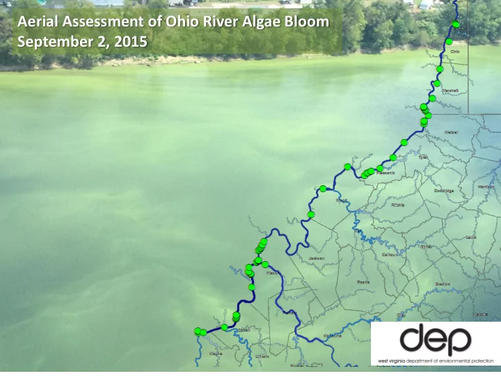
SLIDE 1
Aerial Assessment of Ohio River Algae Bloom September 2, 2015
SLIDE 2
WV State Aviation: Steve Knotts WVDEP – DWWM: John Wirts, Patrick Campbell USACE – Huntington District - Water Management: Andrew Johnson WV DHHR – BPH: Scott Rodeheaver Flew over the WV Section of the Ohio from Big Sandy River upstream to Buffalo Creek near Wellsburg in the Pike Island Pool. Wednesday, Sept 2, 2015 1:45 pm to 4:15 pm.
SLIDE 3
Big Sandy River near mouth. Wayne County, WV No sign of bloom
SLIDE 4
~ River mile (RM) 315. Ceredo, WV Algal bloom evident mostly along banks with occasional streaks of dense algae extending into mainstem
SLIDE 5
RM 298. Just upstream of Ninemile Ck (WV). Near Lesage, WV
SLIDE 6
~ RM 298. Just upstream of Ninemile Ck (WV). Near Lesage, WV
SLIDE 7
RM 270 Near Gallipolis, OH
SLIDE 8
Bloom continued at similar levels upstream. With some areas of lower densities
SLIDE 9 Mouth of Kanawha River. Enters Ohio River at RM 266. No blooms evident in
- Kanawha. (Green streaks are
reflection off glass)
SLIDE 10
RM 260 – mid-stream. Upstream of Point Pleasant, WV
SLIDE 11
RM 260. Upstream of Point Pleasant, WV Kyger Power Plant
SLIDE 12
RM 259. Upstream of Point Pleasant, WV
SLIDE 13
RM 256. Just upstream Cheshire OH
SLIDE 14
Skipped section around Ravenswood because of time constraints
SLIDE 15
Belleville L&D RM 204. Diffuse bloom observed
SLIDE 16
Mouth of Muskingum River ~ RM 172. No bloom observed in Muskingum.
SLIDE 17
RM 158.5 Between Willow Island and St. Marys Broadback Island
SLIDE 18 RM 155.
Downstream end
SLIDE 19
Skipped an area downstream of Sistersville because of weather
SLIDE 20
RM 139 Just downstream of Sistersville, WV
SLIDE 21
RM 119.5 Ohio bank across from Natrium, WV
SLIDE 22
Sunfish Creek at Clarington, OH Enters river at RM 118.
SLIDE 23
Fish Creek – Enters Ohio at RM 114. Unknown whether algae had been blown or drifted in from Ohio River or developed in tributary.
SLIDE 24
~ RM 117. Just Upstream of Natrium, WV / Clarington, OH
SLIDE 25 Buffalo Creek – Near Wellsburg, WV at RM 75 No bloom detected. Had seen heavy algae the week
SLIDE 26
No algae blooms were seen on this flight in Ohio River upstream of Moundsville, WV to the point where Buffalo Creek enters the Ohio River in Brooke County.