Scientific Ocean Drilling Behind the Assessment of Geo-Hazards from - - PDF document

scientific ocean drilling behind the assessment of geo
SMART_READER_LITE
LIVE PREVIEW

Scientific Ocean Drilling Behind the Assessment of Geo-Hazards from - - PDF document

Introduction Submarine Slides and Scientific Drilling doi:10.2204/iodp.sd.4.14.2007 by Angelo Camerlenghi, Roger Urgeles, Gemma Ercilla, and Warner Brckmann Workshop Reports Scientific Ocean Drilling Behind the Assessment of Geo-Hazards from


slide-1
SLIDE 1

Introduction

The workshop ‘Scientific Ocean Drilling Behind the Assessment of Geo-hazards from Submarine Slides’ was held

  • n 25–27 October 2006 in Barcelona (Spain). Fifty mainly

European scientists and industry representatives attended from a wide spectrum of disciplines such as geophysics, stratigraphy, sedimentology, paleoceanography, marine geotechnology, geotechnical engineering, and tsunami modeling.

Submarine Slides and Scientific Drilling

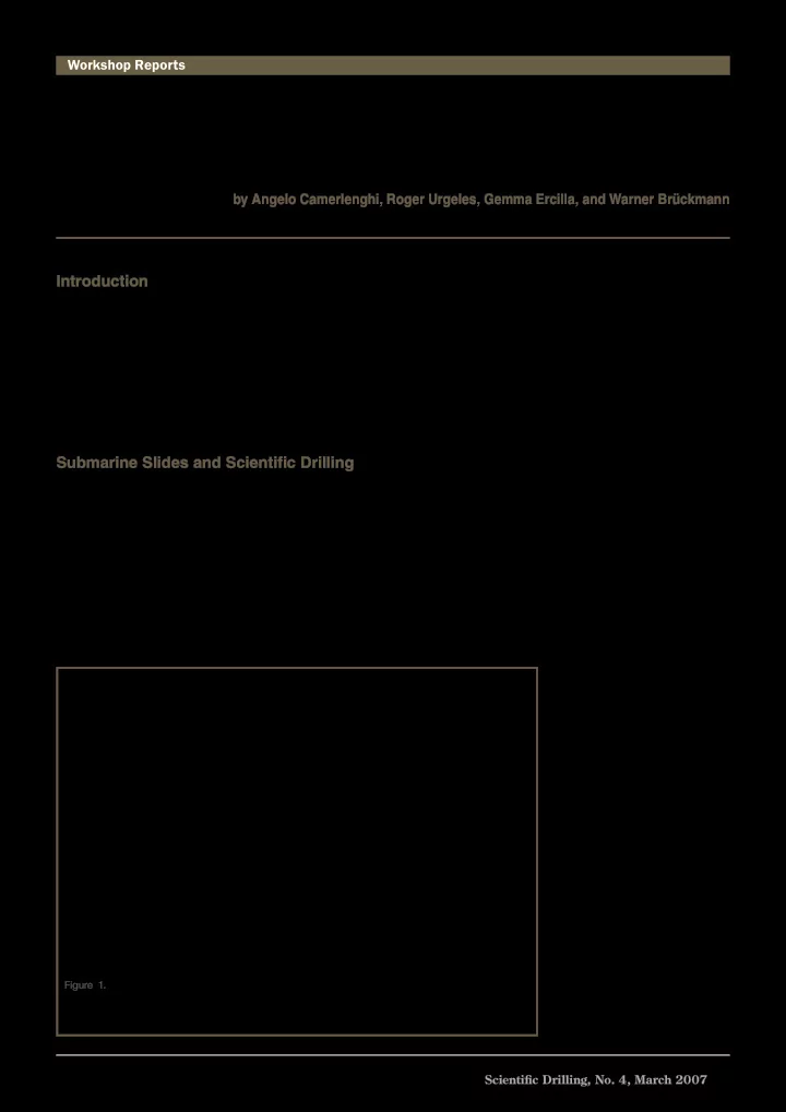
Submarine slides pose societal and environmental risks to offshore infra-structures (platforms, pipelines, cables, sub-sea installations), and coastal areas including tsunamis (Fig. 1), and they can dramatically change the marine

  • environment. Triggering mechanisms include earthquakes,

gas hydrate dissociation, instability of volcanic flanks, and fluid flow. Research on submarine slides may also help understand paleoseismicity, climate change, and sedimentary facies on basin evolution relevant to hydrocarbon reservoir characterization. The Storegga Slide off Norway and close to the Ormen Lange Gas Field remains the only medium to large submarine mass movement that has been investigated to confirm the geometry as well as the in situ stresses and their evolution at the time of failure (‘Ormen Lange Project’, Solheim et al., 2005). This study concluded that extensive geophysical surveys, seabed characterization, geotechnical boring, and in situ measurements both inside and outside the slide bodies are needed to reliably define and constrain the lateral variability of geotechnical parameters (Fig. 2). Drilling is required to address the following four questions. What is the frequency of submarine slides? Drilling and appropriate high resolution stratigraphic and geo-chrono- logic tools can establish the history and frequency of submarine slope failures. Currently only a few mega events such as the Storegga Slide (roughly 8150 years old) have been dated with sufficient accuracy. Many medium and small recent submarine slides are known to have higher rates of recurrence (Hühnerbach and Masson, 2004). What is the tsunamigenic potential of a submarine slide? Tsunami generation is controlled not only by slide geometry (slide volume, area, water depth) but also by slide kinematics (slide acceleration and velocity). Sampling and in situ measure- ments are needed to understand the rheology of the slide. Evidence suggests that shearing of the landslide mass is significantly different at its base compared to its top, which translates into a distinct profile

  • f

physical properties (Expedition 308 Scientists, 2005). Insights

  • btained through sampling of the

failed sediments may help predict the failure dynamics of a yet stable slope. Do precursory phenomena of slope failure exist? We need to determine which transient signs might indicate imminent slope instability and improve

  • ur

capability to predict events of slope instability. Consequently, it

Figure 1. Offshore geohazards. Submarine slides generated by human activity are recognized as submarine geohazards for first party seabed structures and for third party (population) because of their potential to generate tsunamis. Submarine slides are known to occur also as a consequence of the natural evolution of continental margins.

Scientific Drilling, No. 4, March 2007 45

Scientific Ocean Drilling Behind the Assessment of Geo-Hazards from Submarine Slides

by Angelo Camerlenghi, Roger Urgeles, Gemma Ercilla, and Warner Brückmann

doi:10.2204/iodp.sd.4.14.2007

Workshop Reports

slide-2
SLIDE 2

46 Scientific Drilling, No. 4, March 2007

is necessary to conduct long-term monitoring of pore pressure, temperature and hole inclination in slopes where failure might occur in a relatively short term. Investigation of the geochemistry of pore fluids may tell if clay minerals such as smectite released mineral water due to shear. Drilling and monitoring are also important to describe how slow defor- mation of slopes (creep) occurs and to relate seismic reflection features to active sediment deformation. What makes up weak layers in continental slope sediments? Submarine landslides are often found to be rooted at one or more stratigraphic levels. These levels likely represent a “weak layer” that plays a fundamental role in landslide initi- ation and in determining slide volume and geometry. In glaciated margins weak layers have been identified in contou- ritic deposits that were formed during interglacial periods and were rapidly buried under thick glacial-marine deposits (Bryn et al., 2005). The occurrence of weak layers in non- glaciated margins is poorly understood.

Hypotheses and Models

While a general relationship between slope instability and natural climatic cycles has been demonstrated on the Northern European margin (Solheim et al., 2005), the mechanisms behind the generation of submarine slope insta- bility are still poorly understood because of lack of deep penetration sediment cores. There are at least two hypotheses and models that could be tested through drilling. The focusing of fluids and lateral transfer of stresses can trigger slides. Two-dimensional modeling of the New Jersey margin suggests that lateral fluid flow in permeable beds under differential overburden stresses produces fluid pressures that approach the lithostatic stress where

  • verburden is thin. This transfer of pressure may cause

slope failure initiation at the base of the continental slope 1.

Workshop Reports

(Dugan and Flemings, 2000). IODP Expedition 308 tested a hydrogeologic model by which pore fluids are laterally advected under certain loading and stratigraphic condi- tions (Behrmann et al., 2006). Excess pore pressure in highly permeable sediments is transferred to zones of lower overburden with an important effect on slope

  • stability. Similar pore fluid advection might be caused by

glacial loading of permeable sediments (e.g., Storegga Slide or Antarctic Peninsula margin). The Clathrate Gun Hypothesis (Kennett et al., 2000) states that methane emissions from gas hydrate dissoci- ation induced by climate change and bottom water warming is related to submarine slide activity. The un- roofing of buried hydrate-bearing sediments by submarine slides enhances methane emissions from the seafloor by instantaneously decreasing the confining pressure. The carbon isotope chemistry and the assemblages of benthic calcareous foraminifera close to paleo-slide heads might contain a record of paleo-methane seeps as well as other (micro) biological indicators.

Conclusions

Geohazards have mainly been addressed in scientific drilling campaigns as a complementary goal. Future and dedicated drilling experiments should address mega slides as well as small to medium slides. Understanding the mechanics of the less frequent, but potentially catastrophic, mega slides requires a large amount of site survey data and might require a multi-expedition effort. Smaller slides occur with a frequency close to that of natural hazards considered in the determination of the 500 years risk. They may cause damage to seabed installations and generate tsunami waves that, although being relatively small, may cause onshore damage and casualties in densely populated coastal regions. More than one small to medium submarine slide can be 2.

Figure 2. Conceptual relationships between marine sediment geotechnical properties, submarine slide triggers, and sediment failure mechanisms. Cc = Compressibility index Cs = Swelling index γ = Unit weight k = Hydraulic conductivity cv = Coefficient of consolidation c’ = Cohesion φ’ = Friction angle u = Pore water pressure Cu = Undrained shear strength Ip = Plasticity index St = Sensitivity Cur = Remolded undrained shear strength IL = Liquidity index µ = Viscosity τc = Yield strength ErA = Available remolding energy ErN = Needed remolding energy

slide-3
SLIDE 3

Scientific Drilling, No. 4, March 2007 47 addressed effectively in one single drilling expedition, but may require a multi-platform approach supporting strati- graphic drilling, geotechnical drilling, and installation of borehole and seafloor observatories. High-resolution seafloor mapping, possibly using deep- towed devices or remotely operated vehicles (ROV), and the integration of bathymetric and backscatter information will be necessary to obtain the best morphologic and acoustic characterization of recent slides. High-resolution 3-D seismic data acquisition will be important to define targets within the unfailed sediments, scar and detachment area, evacuation zone, and accumulation area within a slide complex. For appropriate post-cruise geotechnical analyses, the drilling system must obtain high-quality undisturbed geotechnical

  • samples. Existing advanced piston coring and narrow kerf

rotary drilling were considered most prospective for imple- mentation on IODP drilling vessels. Long term monitoring of key parameters in boreholes (e.g., pore pressure, hole incli- nation, or ambient acoustic noise) can utilize the well-estab- lished Circulation Obviation Retrofit Kit (CORK) technology. A link with existing seafloor observatories initiatives was recognized as very important for remote and real-time monitoring. Drilling to understand submarine slope instability is perceived as highly multidisciplinary. Drilling proposals should address scientific questions outlined above in a variety of geological environments. The teams of proponents should include a wide range of tsunami experts, sedimento- logists, paleoceanographers, geotechnical engineers, and deep-sea observatories. The international community will further stress the importance of Geohazards research during the upcoming IODP Geohazards Workshop in Summer 2007 (see workshop announcements on page 51).

Acknowledgements

The workshop was funded by the European Science Foundation within the Workshops on Marine Research Drilling (MAGELLAN) series. Co-funding was provided by the European Consortium for Ocean Drilling (ECORD), the Consejo Superior de Investigaciones Científicas (CSIC), the Faculty of Geology of the University of Barcelona (UB), the IGCP Project 511 (Submarine Mass Movements and their Consequences), and the Spanish Ministry of Education and Science (MEC).

References

Behrmann, J.H., Flemings, P.B., John, C.M., and IODP Expedition 308 Scientists, 2006. Superfast sedimentation, overpres- sures and focused fluid flow, Gulf of Mexico continental

  • margin. Sci. Drill., 3:12–17, doi: 10.2204/iodp.sd.2.03.2006

Bryn, P., Berg, K., Stoker, M.S., Haflidason, H., and Solheim, A.,

  • 2005. Contourites and their relevance for mass wasting

along the Mid-Norwegian Margin. Mar. Petr. Geol., 22: 85–96. Dugan, B., and Flemings, P.B., 2000. Overpressure and fluid flow in the New Jersey continental slope: implications for slope failure and cold seeps. Science, 289:288–291. Expedition 308 Scientists, 2005. Overpressure and fluid flow processes in the deepwater Gulf of Mexico: slope stability, seeps, and shallow-water flow. IODP Prel. Rept. 308. doi:10:2204/iodp. pr.308.2005 Hühnerbach, V., and Masson, D.G., 2004. Landslides in the North Atlantic and its adjacent seas: an analysis of their morphology, setting and behaviour. Mar. Geol., 213:343–362 Kennett, J.P., Cannariato, K.G., Hendy, I.L., and Behl, R.J., 2000. Carbon isotopic evidence for methane hydrate instability during Quaternary interstadials. Science, 288: 128–133. Solheim, A., Bryn, P., Sejrup, H.P., Mienert, J., and Berg, K., 2005. Ormen Lange—an integrated study for the safe devel-

  • pment of a deep-water gas field within the Storegga Slide

Complex, NE Atlantic continental margin; executive

  • summary. Mar. Pet. Geol., 22:1–9.

Authors

Angelo Camerlenghi, ICREA and GRC Geociències Marines, Departament d’Estratigrafia, Paleontologia i Geociències Marines, Universitat de Barcelona, C/ Martí i Franquès, s/n, E-08028 Barcelona, Spain, e-mail: angelo. camerlenghi@icrea.es. Roger Urgeles, GRC Geociències Marines Departament d’Estratigrafia , Paleontologia i Geociències Marines, Universitat de Barcelona C/ Martí i Franquès, s/n, E-08028 Barcelona, Spain. Gemma Ercilla, Departamento de Geología Marina y Oceanografia Física, Instituto de Ciencias del Mar, CMIMA- CSIC, Paseo Marítimo de la Barceloneta 37-49, E-08003 Barcelona, Spain. Warner Brückmann, Leibniz-Institute for Marine Sciences, IFM-GEOMAR, Wischhofstr. 1-3, D-24148 Kiel, Germany.

Related Web Links

http://www.esf.org http://www.geohazards.no/IGCP511

Photo and Figure Credits

  • Fig. 1. Courtesy of Norwegian Geotechnical Institute (NGI)

and the International Centre for Geohazards (ICG)

  • Fig. 2. by J. Locat, Laval University, Quebec, Canada.