
SLIDE 1
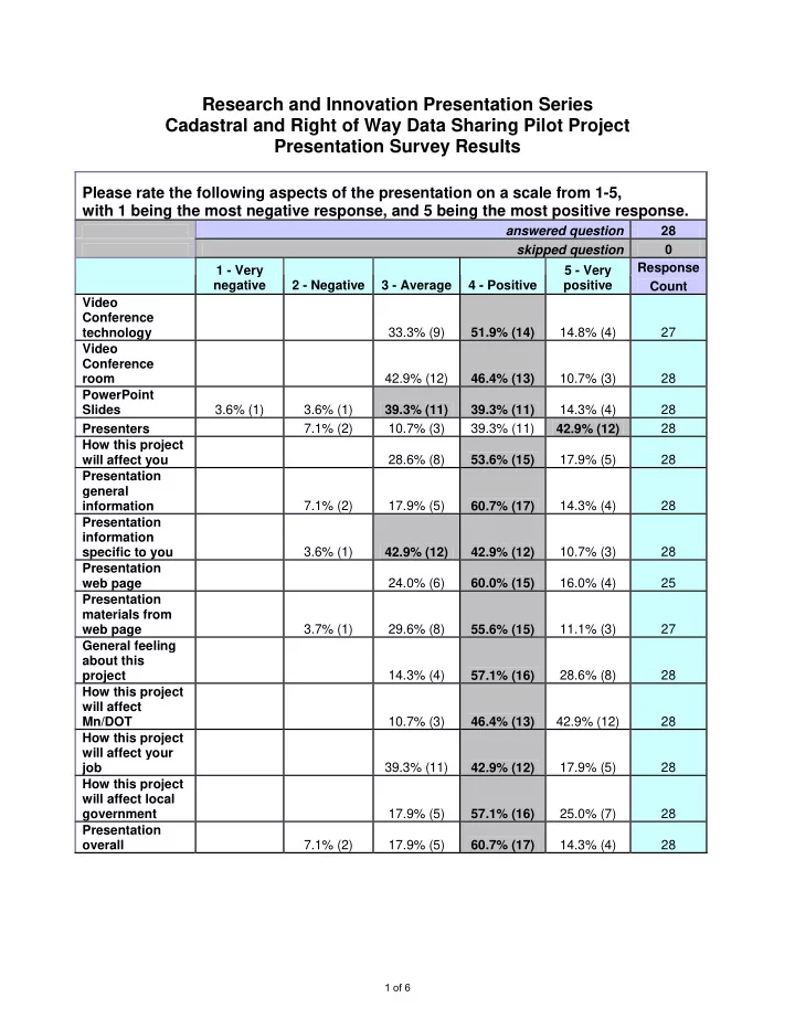
Research and Innovation Presentation Series Cadastral and Right of Way Data Sharing Pilot Project Presentation Survey Results
Please rate the following aspects of the presentation on a scale from 1-5, with 1 being the most negative response, and 5 being the most positive response.
answered question 28 skipped question Response 1 - Very negative 2 - Negative 3 - Average 4 - Positive 5 - Very positive Count Video Conference technology 33.3% (9) 51.9% (14) 14.8% (4) 27 Video Conference room 42.9% (12) 46.4% (13) 10.7% (3) 28 PowerPoint Slides 3.6% (1) 3.6% (1) 39.3% (11) 39.3% (11) 14.3% (4) 28 Presenters 7.1% (2) 10.7% (3) 39.3% (11) 42.9% (12) 28 How this project will affect you 28.6% (8) 53.6% (15) 17.9% (5) 28 Presentation general information 7.1% (2) 17.9% (5) 60.7% (17) 14.3% (4) 28 Presentation information specific to you 3.6% (1) 42.9% (12) 42.9% (12) 10.7% (3) 28 Presentation web page 24.0% (6) 60.0% (15) 16.0% (4) 25 Presentation materials from web page 3.7% (1) 29.6% (8) 55.6% (15) 11.1% (3) 27 General feeling about this project 14.3% (4) 57.1% (16) 28.6% (8) 28 How this project will affect Mn/DOT 10.7% (3) 46.4% (13) 42.9% (12) 28 How this project will affect your job 39.3% (11) 42.9% (12) 17.9% (5) 28 How this project will affect local government 17.9% (5) 57.1% (16) 25.0% (7) 28 Presentation
- verall