SLIDE 1 Marino Carhuapoma
- MSc. Cadastral Engineering
mcarhuapoma@ideasg.org
SLIDE 2
- 1. Goals of Implementation
- 2. Introduction
- 3. Why Based in Open Source
- 4. Server Environment
- 1. Spatial Database
- 2. Web Map Server
- 5. Desktop Environment
- 1. Spatial Analysis
- 2. Integrated Reports
- 6. Web Environment
- 1. Search and Visualization
- 2. Update the system via Web
- 7. Mobile environment
- 1. Search and Visualization
- 2. Update the system via Mobile
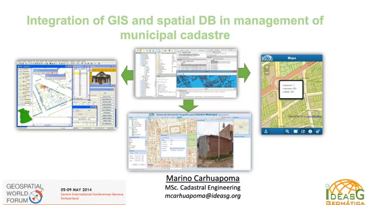
- 8. Integrate Process
- 9. Conclusions
SLIDE 3
- Validate, standardize and migrate all CAD Base
and alphanumeric information to the Spatial Database
- To obtain data integrated and centrally
- Designing, Developing and Deploying Desktop
application, Web application and mobile application for management of cadaster
SLIDE 4
This project started as an initiative to improve the automation and improved land management in municipalities. In Peru there is the law of the National Integrated Cadastral Information Property and Tax system (SNCP) ,based on the law is being implemented this geographic information system. It is being used open source software in all components , because the budget of the municipality is quite limited. Before the implementation of the solution , the information and data was being handled in CAD and alphanumeric data base formats, now with the implementation process will everything of data integrated into the new system.
SLIDE 5
One reason to use open source software is because limited budget for the implementation of the solution It has been evaluated the development with commercial software alternatives according to the requirements of the solution For the purposes of local governments , requirements and scope at this stage of the solution , the open source software meets the requirements and have necessary conditions.
SLIDE 6
The system has been designed from at least according to the data structure of National Integrated Cadastral Information Property and Tax system (SNCP) However to get to work as a system had to be added and improved the database model , because the system provides multimedia management ,audit, handling security, user roles and access, statistics, reports, thematic analysis, among others that were not in the scope of the standard. The spatial Layers is managed by geoserver as a WMS, and WFS.
SLIDE 7
To work with the system, we need to migrate all the information in a PostGIS spatial layers, because the base system layers are connected to spatial database, or synchronize by geojason to PostGIS Postgres and PostGIS Database is used as a repository for alphanumeric, spatial and multimedia data
SLIDE 8 Geoserver is used as base map server , in geoserver is configured the layers of information services like WMS, WFS for web applications and mobile applications The Styles
base presentation layer is configured in geoserver.
SLIDE 9 The desktop environment is where most advanced GIS operations, geo processes, spatial analysis and reporting is done, among others. It has been personalized in gvsig application so you can make the processes
Functionality has been added according to need, this is possible since we could run gvsig from source code .
SLIDE 10 Spatial analyzes performed automatically, with simple user interaction Spatial analysis processes usually performed manually by GIS software, have been programmed to run it automatically. These automated spatial analysis is used for making day to day decisions of municipal
SLIDE 11 Are integrated and shows ,geographic information, statistics, cadastral unit pictures and alphanumeric , which become documents
communication between municipal different areas. The desktop environment reports are rich in design and functionality .
SLIDE 12 Users anywhere can do basic GIS
- perations as query, viewing, browsing,
hide and show layers, print, measure areas and perimeters, export image, update information to the central database. In this presentation we show some results of the system Also say that the system is still in development process
SLIDE 13 In the web environment system can do searches by lots, blocks, sectors, by owner, and by cadastral code. we can also consult each parcel individually using spatial navigation The system is capable
displaying multimedia information for each cadastral unit. We can review some thematic maps inside web environment also.
SLIDE 14
As in the desktop environment, here you can update the information from the web, it is useful for users authenticated in other communities and do not have access to the intranet
SLIDE 15
Since mobile users can also interact with the integrated system, can view, search, geo locate, update basic information system. The mobile system environment is still under development, however we can display results according to project scope. At this moment the system is in test however the functionality according to scope is fully integrated.
SLIDE 16
In the mobile environment we can make the search for cadastral codes based in blocks and parcels. We can on and off layers , review quick information for each parcel, and Geolocate, in this case near to Geneva University. Of course we can navigate using zoom+, zoom- , move.
SLIDE 17 The mobile component is designed to make timely updates as the case of the municipality
inspectors in the field , in this example inspector update the municipal license and annotate some incidents to test. Also it is possible to update spatial incidents en the city and save with basic attributes like category. All the updates the geographic
alphanumeric is synchronized to the central database.
SLIDE 18 The system is integrated from the server, clients as desktop, web and mobile, we show a comprehensive process with a step by step example.
- We can import, digitize or migrate information related to the system and for local government
purposes
centralized database we have in this case an layer about a parcel with business with attribute as the municipal licenses status, multimedia, owner, and others.
- We can do advanced desktop changes spatially , join with each other, split into two parts and
- ther necessary processes.
- From desktop, web or Mobile we can update alphanumeric, spatial or multimedia information.
- On the desktop and web environment we can see spatial analysis of city areas , with patterns of
areas, with density , parcels with operating licenses
not and all of the spatial analysis available.
- After updating the information from any environment to the central database , can we view,
query or refresh. The query or analysis have changes instantly.
- Finally we can make decisions with the integrated system
SLIDE 19
- If you do not know your territory you can not manage it
- To get to know the territory we should have the city at
- ur fingertips in one laptop , one tablet or smartphone.
- The decisions do not make the computer or the system
, decisions are made by a person who knows the worldview of citizens, laws, and system reporting interpretation.
SLIDE 20
Further information: Marino Carhuapoma IdeasG SAC Peru mcarhuapoma@ideasg.org www.ideasg.org