redevelopment vision
play

REDEVELOPMENT VISION 591 LIVERPOOL ROAD OVERVIEW Introduction - PowerPoint PPT Presentation

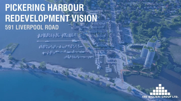
PICKERING HARBOUR REDEVELOPMENT VISION 591 LIVERPOOL ROAD OVERVIEW Introduction Context Vision and Guiding Principles Subject Lands Design Vision Subject Site Proposal Policy Context Next Steps INTRODUCTION CLIENT


  1. PICKERING HARBOUR REDEVELOPMENT VISION 591 LIVERPOOL ROAD

  2. OVERVIEW • Introduction • Context • Vision and Guiding Principles • Subject Lands Design Vision • Subject Site Proposal • Policy Context • Next Steps

  3. INTRODUCTION CLIENT TEAM Picke kerin ring g Harbou rbour r Company pany The Biglieri lieri Group up Ltd. . Plann nning ing and Urban rban Desig sign Norm orm Li Vision ioning ng Archit itecture cture and Urba rban n Desig sign MSLA A Landsca scape and the Publ blic ic Realm lm SKA KA Engine gineering ring Servicing cing HDR DR Corpora rporatio tion Transporta nsportatio tion n and Mobil bility ity Beacon con Environm ronment ntal al Natural tural Heritage ritage Valcoust coustics ics Noise ise RWDI DI Wind Hadda dad d Geot otechnical hnical Geotec techni hnica cal/P l/Pha hase se 1 and 2 ESA Golder r and Associate ociates s Hydrog drogeologic ological al D.A .A.W .W. . Treeca care re Arbo borist rist AECOM M Archae aeology ology J.D .D. . Barnes nes Surveyor yor

  4. INTRODUCTION – THE PROJECT

  5. CONTEXT – SUBJECT LANDS SUBJECT LANDS: Approximately 80 80 • hectares of PHC’s landholdings, inclusive of the water and associated lakebeds in portions of Frenchman’s Bay and Lake Ontario, 591 Liverpool Road and the docking facilities in Frenchman’s Bay.

  6. CONTEXT – SUBJECT SITE SUBJECT SITE: 591 Liverpool Road • City-owned parking lot • lands to the immediate south The Subject Site has a • total area of 2.42 hectares, or 6 a acres. Total frontage of • approximately 86.84 metres on Liverpool Road. The Frenchman’s Bay • Marina office and boat storage yard currently occupy the Site.

  7. CONTEXT – STUDY AREA

  8. CONTEXT - HISTORY

  9. CONTEXT - HISTORY

  10. CONTEXT – SURROUNDING AREA NORTH EAST SOUTH WEST

  11. CONTEXT – LAND USE

  12. CONTEXT – PUBLIC SERVICE FACILITIES

  13. CONTEXT – PARKS AND OPEN SPACES

  14. CONTEXT – ROAD NETWORK

  15. CONTEXT – TRANSPORTATION NETWORK

  16. VISION AND GUIDING PRINCIPLES THE VISION To reconnect the waterfront and its natural amenities to the surrounding neighbourhood and its residents, while enhancing opportunities for new residential, commercial, cultural and recreational uses. GUIDING PRINCIPLES CONNECTED WATERFRONT MIX OF LAND CONNECTED ACTIVE USES – LIVE, SUSTAINABILITY WATERFRONT STREETSCAPES WORK, PLAY

  17. SUBJECT LANDS DESIGN VISION WHAT THE COMMUNITY SAID TO THE CITY ABOUT PARKS AND OPEN SPACES “The waterfront has poor access for anyone who doesn’t live there” “Seniors and the disabled need accessible parks, waterfront trails and picnic areas…” “Intensification in South Pickering must maintain or increase the availability of recreational park space for the City’s residents to enjoy.” “The lakefront is one of the best things about living here.” “A wonderful place to relax, exercise and interact with others.” “Waterfront trails are fun and accessible way for people of all ages to enjoy the natural beauty of Pickering’s waterfront. They should be expanded wherever possible.” (taken from the Pickering Recreation Master Plan, 2017)

  18. SUBJECT LANDS DESIGN VISION

  19. SOFT LANDSCAPE – GREEN SURFACES

  20. SOFT LANDSCAPE – WATER SURFACES

  21. HARD LANDSCAPE – WOOD SURFACES

  22. HARD LANDSCAPE – OTHER SURFACES

  23. SUBJECT SITE PROPOSAL

  24. SUBJECT SITE PROPOSAL REQUIRED APPROVALS An Official Plan Amendment is needed to: Change the Natural Area and Marina Area designation to • Mixed Use – Community Node; Change the Public U Use/Parking a and Boat Storage Area • designation in the Liverpool Road Waterfront Node Development Guidelines to Marina Mixed Use Areas and Liverpool Road Corridor; Permit site-specific permissions for an increase in Net • Residential Density for the Mixed Use Community Node from 140 units per hectare to 340 units per hectare. • Permit a site-specific permission for an increase in the maximum permitted Floor Space Index from 2.5 to 4.4. A Zoning By-law Amendment is needed to: • Change the current zoning from Waterfront Area, “(H) O3B - 2” • in the City of Pickering Zoning By-law 2520 to Community Node (“CN”) Zone with site-specific permissions for increased height and density.

  25. SUBJECT SITE PROPOSAL COMMERCIAL/PUBLIC REALM RESIDENTIAL

  26. PROPOSAL - CONNECTIVITY

  27. PROPOSAL - SUSTAINABILITY

  28. POLICY CONTEXT • Provincial Policy Statement (2014) • Growth Plan for the Greater Golden Horseshoe (2017, now 2019) • The Region of Durham Official Plan (2017) • City of Pickering Official Plan (2018) • City of Pickering Zoning By-law 2520

  29. POLICY CONTEXT – ROD OFFICIAL PLAN The Region of Durham Official Plan (2017)

  30. POLICY CONTEXT - ROD OFFICIAL PLAN REGION OF DURHAM OFFICIAL PLAN CONFORMITY Proposes intensification of an underutilized parcel of land within the current urban boundary of the • City of Pickering. The development proposes a compact built form with a mix of residential, retail, and service uses to • serve future residents and the surrounding neighbourhood. The proposed development includes an internal site design and layout to ensure appropriate traffic • movement and sharing between pedestrians, cyclists and vehicles. The proposed development includes a mix of housing types, including bachelor to three-bedroom • units to serve resident needs throughout an entire lifetime. The proposed development has been designed to provide appropriate setbacks to the natural • heritage features to the east of the property, while providing opportunities for recreational activities with the potential for a boardwalk to serve the residents of the proposed development as well as the public. The proposed development will improve access to the waterfront through providing a public • boardwalk along the southern limits of the Site. The Site can be serviced efficiently by utilizing only existing services. •

  31. POLICY CONTEXT – COP OFFICIAL PLAN City of Pickering Official Plan Schedule I – Land Use Structure

  32. POLICY CONTEXT – COP OFFICIAL PLAN City of Pickering Official Plan Map 13 – Neighbourhoud 3 3 – Bay Ridges

  33. POLICY CONTEXT – COP OFFICIAL PLAN City of Pickering- Section C1 – Liverpool Road Waterfront Node Development Guidelines – Figure A

  34. POLICY CONTEXT – COP OFFICIAL PLAN City of Pickering Official Plan Schedule II Transportation System

  35. POLICY CONTEXT – COP OFFICIAL PLAN CITY OF PICKERING O OFFICIAL PLAN CONFORMITY Provides infill development along the periphery of an established Low Density Area, that respects the • existing and emerging character of the community in terms of built form, massing, setbacks and interface with the public realm as discussed in the Liverpool Road Waterfront Node Development Guidelines; Provides housing that offers more variety in terms of form, providing multiple unit sizes, including • bachelor to 3-beedroom units, to provide opportunities for area residents to downsize within their current neighbourhood to age-in-place; Provides ground-related neighbourhood commercial uses to serve the daily needs of residents; • Provides increased opportunities for public access to the waterfront area through implementation of a • public boardwalk and pedestrian promenade to serve residents, tourists and boaters; Provides 3-bedroom units that can serve larger families within close proximity to transit, schools, • parks, community centres and other services to serve current and future needs; and, Can be accommodated by the existing infrastructure, including transportation and servicing. •

  36. POLICY CONTEXT – ZONING BY-LAW 2520 ZONING BY-LAW - CURRENT ZONING BY-LAW - PROPOSED Community Node – CN-XX (Site-Specific Permissions) Waterfront Area – (H) O3B-2 Open Space – OS Open Space – OS-HL-5 Natural Heritage System - NHS

  37. NEXT STEPS Public Consultation through S Social Pinpoint W Website: • TBG will utilize Social Pinpoint as a key tool throughout the engagement process. • Social Pinpoint contains an intuitive drag and drop mapping tool for engaging communities in • the planning process. TBG will use this website to post all relevant information to the project, including all supporting • Reports, Studies and Drawings as well as key dates. The Social Pinpoint website will be posted on The Biglieri Group website as of Monday, October • 21 21 st. st. Additional Privately-Hosted Public Open House: • Changes will be made to the proposal after all comments are received from the first submission • circulation and after all public comments are provided to us by Planning Staff. Date: TBD (notice w will b be posted on the Social P Pinpoint Website). • Statutory Public Meeting: • The City of Pickering will host the Statutory Public Meeting at the City of Pickering Civic Centre. • The public open house portion will take place at 6pm in the lobby area with the Public Meeting • portion before Council commencing at 7pm. TBG Staff will be present at this meeting to discuss the proposal with all members of the public. • Date: TBD (notice w will b be circulated). •

  38. THANK YOU

Download Presentation
Download Policy: The content available on the website is offered to you 'AS IS' for your personal information and use only. It cannot be commercialized, licensed, or distributed on other websites without prior consent from the author. To download a presentation, simply click this link. If you encounter any difficulties during the download process, it's possible that the publisher has removed the file from their server.

Recommend


More recommend