PUBLIC MEETING for PROPOSED SH 48 IMPROVEMENTS BRIDGE REPLACEMENT - - PowerPoint PPT Presentation

public meeting for
SMART_READER_LITE
LIVE PREVIEW

PUBLIC MEETING for PROPOSED SH 48 IMPROVEMENTS BRIDGE REPLACEMENT - - PowerPoint PPT Presentation

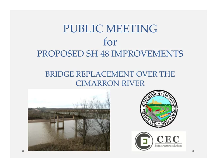
PUBLIC MEETING for PROPOSED SH 48 IMPROVEMENTS BRIDGE REPLACEMENT OVER THE CIMARRON RIVER Division 8 Information Division 8 Engineer Randle White Total Road Miles 1,664 Total Interstate Miles 40 Total Bridges 1,118


slide-1
SLIDE 1

PUBLIC MEETING for

PROPOSED SH 48 IMPROVEMENTS

BRIDGE REPLACEMENT OVER THE CIMARRON RIVER

slide-2
SLIDE 2

Division 8 Information

  • Division 8 Engineer

Randle White

  • Total Road Miles

1,664

  • Total Interstate Miles

40

  • Total Bridges

1,118

  • Counties Serviced

11

slide-3
SLIDE 3

Meeting Materials

slide-4
SLIDE 4

Purpose of Meeting

  • To inform the public of ODOT’s plan to replace the

existing deteriorated bridge that carries SH 48 over the Cimarron River

  • Receive comments from the public in regard to the

proposed bridge replacement project that can be included in the project development process.

slide-5
SLIDE 5

Purpose of Project

  • Improve the safety and functionality of the SH 48

crossing over the Cimarron River

slide-6
SLIDE 6

Existing Conditions

  • 2 lane highway built in 1961
  • US Army Corps of Engineers project to relocate SH 48
  • Currently has 12’ lanes and 8’ shoulders with 6’ from lane to guardrail
  • Substandard guardrail
  • 1961 Project included existing bridge
  • 28’ clear roadway
  • (curb to curb)
  • 6 Spans, 743’ long
  • Structurally Deficient
  • Inadequate to carry legal

loads, whether caused by

  • bsolete design standards,

structural deterioration or waterway inadequacy.

slide-7
SLIDE 7

Existing Conditions

slide-8
SLIDE 8

Traffic Volume

  • Current Traffic Volume (2014)
  • 2,500 vehicles per day
  • 10% Trucks
  • Future Traffic Volume (2034)
  • 3,600 vehicles per day
  • 10% trucks
slide-9
SLIDE 9

Project Scope

  • Replace the existing 52 year-old bridge that carries

SH 48 over the Cimarron River with a new bridge, 16’ wider than the existing bridge.

  • Bridge will consist of two 12’ wide driving lanes and two 10’

wide shoulders, 44’ clear roadway

  • Bridge length similar to the existing bridge length
  • Widen the approach roadway north and south of

the bridge to consist of two 12’ wide driving lanes and two 10’ wide shoulders.

  • Begin approximately 2,000’ south of the bridge and end

approximately 550’ north of the bridge

  • Guardrail on the approach roadways will be replaced.
slide-10
SLIDE 10

Project Constraints

  • Keystone Wildlife Management Area
  • US Army Corps of Engineers property adjacent to both

sides of the roadway

  • Flood Storage area for Keystone Lake & Wetlands on

both sides of project

  • Wetland Mitigation likely required
  • Flood Pool Mitigation possible
  • Potential Threatened & Endangered Species Habitat

Impact

  • American Burying Beetle (ABB)
  • Whooping Crane
  • Piping Plover
  • Red Knot
slide-11
SLIDE 11

Bridge Replacement Preferred Option

  • Reconstruct on Existing Alignment with road closed
  • Provide alternate route during construction
  • Results in the least construction cost and impacts to

environmentally sensitive areas but with higher impact to road users.

  • Available Detour Route on SH 51 and US 64 is 26 miles long

from south end of bridge to north end of bridge.

  • Anticipate a project duration of approximately 180

calendar days

  • Utilize a performance incentive to speed

construction

  • Scheduled letting is February 2017
slide-12
SLIDE 12

Bridge Replacement Options Considered

  • Reconstruct on Existing Alignment & maintain traffic

during construction

  • Requires construction of a temporary bridge to maintain

traffic

  • Increased construction costs and impacts to the

environmentally sensitive areas adjacent to the highway

slide-13
SLIDE 13

Bridge Replacement Options Considered

  • Reconstruction on slight offset alignment
  • Shift centerline of roadway and bridge approximately 26’
  • Increased impacts to the environmentally sensitive areas

adjacent to the highway

  • Additional costs incurred:
  • Foundation construction to support phased bridge
  • Right of way acquisition and rock excavation at the north end
  • f the structure to tie existing roadway to the offset bridge
  • Embankment construction at the south end of the bridge to

tie existing roadway to the offset bridge

  • Mitigation required due to environmental impacts
slide-14
SLIDE 14

Bridge Replacement Options Considered

  • Accelerated Bridge Construction
  • Build bridge beams and deck parallel to the existing bridge, then

slide into place

  • Increased impacts to the environmentally sensitive areas

adjacent to the highway to access site & construct bridge in initial location

  • A challenging site for this bridge construction methodology
  • Additional costs incurred:
  • Foundation & pier construction to support the new bridge

superstructure in initial location

  • Construction costs of moving the new bridge superstructure

into final location

  • Construction of new permanent bridge foundation & piers

under the existing bridge while in use

  • Mitigation required due to environmental impacts
slide-15
SLIDE 15

Next Steps

  • Receive comments from the public
  • Proceed with preliminary design
  • Right-of-way acquisition & utility relocation

scheduled for 2015

  • Finalize the design
  • Construction in 2017
  • $7,663,800 in the ODOT 8 Year Construction Plan for right-
  • f-way acquisition, utility relocation, and construction
slide-16
SLIDE 16

Comments

  • Preferred road closure timeframe?
  • Please provide comments
  • now in open forum
  • in writing on the forms provided
  • by email to:
  • environment@odot.org
  • comments due by January 15, 2015
slide-17
SLIDE 17

Questions

Thank you for your attendance tonight