
SLIDE 1
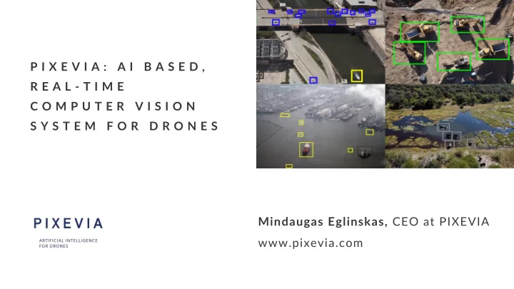
P I X E V I A : A I B A S E D , R E A L - T I M E C O M P U T E R V I S I O N S Y S T E M F O R D R O N E S Mindaugas Eglinskas, CEO at PIXEVIA www.pixevia.com
P I X E V I A : A I B A S E D , R E A L - T I M E C O M P U T E R - - PowerPoint PPT Presentation
P I X E V I A : A I B A S E D , R E A L - T I M E C O M P U T E R V I S I O N S Y S T E M F O R D R O N E S Mindaugas Eglinskas, CEO at PIXEVIA www.pixevia.com Origins in R&D projects for Lithuanian MoD. Autonomous systems research
P I X E V I A : A I B A S E D , R E A L - T I M E C O M P U T E R V I S I O N S Y S T E M F O R D R O N E S Mindaugas Eglinskas, CEO at PIXEVIA www.pixevia.com
Origins in R&D projects for Lithuanian MoD. Autonomous systems research at Vilnius University (2004 – 2017)
4
5
CORE
Real-time imaging
CORE X1
Hardware interfaces
OBJECTS
AI based object recognition
NAV
Navigation
FUSION
Information / sensor fusion
Integrates AI technology in daily commercial drone operations. Uses NVIDIA Jetson TX1 and PIXEVIA for: First responder
Inspection
Real-time onboard mapping
Drones with AI for security applications. Uses NVIDIA Jetson TX1 and PIXEVIA system: carrierboard, pipelines and
Fully autonomous control Fully autonomous information processing Fusion of information from different machines and data sources
cars (with number plate recognition) trucks boats people heavy machinery
Automated inspection: power lines utility poles insulators foreign objects
Containers Wagons Locomotives Cars Materials Packages
Parkings Car flows Persons Security
Intelligent real-time imaging: collection, transformation, communication
Interfaces with sensors and file formats (input) On-board image processing. Image processing pipelines Image processing modules Geographical metadata Distributed processing Industry standards
…
Object detection, properties of objects (size, speed, coordinates)
Cars / Trucks License plate recognition People Face detection Other objects: boats, environment, etc.
Visual position estimation
Visual odometry Image-map matching Foreign object detection on the landing site
…
Fusion of information in real-time
Information fusion from different sources (drones, cameras) Vizualization on 3D map
USB3 / USB2 SD-card UART HDMI GPIO CAN miniPCIe CSI I2C SPI PWM Accel, gyro, compass, barometer
Long range digital datalink (Microhard) Industrial block camera GPRS datalink Thermal imaging camera Gimbal control Ultra fast camera for visual
Wifi , local communcations
Spaghetti type of integration will kill any bigger project OpenVX / Gstreamer NVIDIA provides accelerated Gstreamer modules for encoding DDS for real time communication Processing can be changed before the mission or during the flight
Every video frame contains geographical information:
drone/camera, angles of sensors, camera geometry. Allows integration with GIS systems, provides data for later learning.
HARDWARE NVIDIA Frameworks Other frameworks
VisionWorks (OpenVX graph) CUDA OpenCV with CUDA optimization Caffe cuDNN
cuDNN Caffe Fully convolutional network Single shot detection Filtering after detection
31
600 people doing labeling
MobilEye photo
(if can play more than human plays through all life)
(if can see more than human sees through all life) Terrible performance with small datasets
210 000 points, 90 seconds on Jetson TX1, 4 images
Visual odometry Image - map matching Terrain segmenation
Deep neural networks 500 000 training item dataset. Convolutional neural network, cuDNN
Multiple hyphothesis tracking
Web / Qt via HDMI and datalinks
CORE
Real-time imaging
CORE X1
Hardware interfaces
OBJECTS
AI based object recognition
NAV
Navigation
FUSION
Information / sensor fusion
P I X E V I A : A I B A S E D , R E A L - T I M E C O M P U T E R V I S I O N S Y S T E M F O R D R O N E S Mindaugas Eglinskas, CEO at PIXEVIA www.pixevia.com