
SLIDE 1
Terri S. Hogue
Associate Professor Civil and Environmental Engineering Colorado School of Mines
January 13, 2014
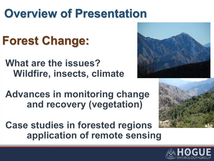
Overview of Presentation Forest Change: What are the issues? - - PowerPoint PPT Presentation
Overview of Presentation Forest Change: What are the issues? Wildfire, insects, climate Advances in monitoring change and recovery (vegetation) Terri S. Hogue Associate Professor Civil and Environmental Engineering Case studies in forested
Terri S. Hogue
Associate Professor Civil and Environmental Engineering Colorado School of Mines
January 13, 2014
3
NASA Earth Observatory August 2012
4
WEsterline
Longer ¡fire ¡dura,ons ¡and ¡longer ¡fire ¡seasons ¡ ¡ since ¡mid-‑1980’s ¡
§ Increase ¡in ¡large-‑wildfire ¡frequency ¡ § Warmer ¡temperatures ¡and ¡earlier ¡spring ¡melt ¡à ¡ increased ¡wildfire ¡ac,vity ¡
Westerling et al., 2009
Civil & Environmental Engineering | Hydrologic Sciences and Engineering
Hogue Research Group
7
acres in western North America since its start in 1996.
southern Wyoming.
epidemic in Colorado and Wyoming contains the headwaters for rivers that supply water to 13 western states.
(source: US Forest Service http://www.fs.usda.gov/main/barkbeetle/aboutepidemic,)
Mountain Pine Beetle (actual size:1/8 to 1/3 inch
Source: CSU Extension
8
9
Mikkelson et al., 2013
UCS, 2014
11
UCS, 2014
14
(Normalized Difference Vegetation Index / Enhanced Vegetation Index)
(Potential Evapotranspiration)
(Actual Evapotranspiration)
15
(Normalized Difference Vegetation Index / Enhanced Vegetation Index)
(Potential Evapotranspiration)
(Actual Evapotranspiration)
16
Product: MCD12Q1 Platform: Combined Terra & Aqua Grid Resolution: 500x500 m Temporal Resolution: Yearly
IGBP land cover types found in MCD12Q1 MODIS product. ¡
Global Land Cover as defined by MODIS MCD12Q1 for even years between 2000 and 2010. Greens indicate areas of forest canopy cover and yellows indicate areas of grassland type vegetation.
17
(Normalized Difference Vegetation Index / Enhanced Vegetation Index)
(Potential Evapotranspiration)
(Actual Evapotranspiration)
Day 1 Day 17 Day 33
* * * * * 1 2
2.5
NIR RED NIR NIR BLUE
EVI C C L ρ ρ ρ ρ ρ ⎡ ⎤ − = ⎢ ⎥ + − + ⎣ ⎦ – Reduced soil and atmospheric interference (compared to NDVI, LAI) – 16 day series – 250 m resolution – Savitzky-Golay Filter
(Jonsson and Eklundh,2004)
19
200 201
Product: MOD13A1 / MYD13A1 Platform: Terra & Aqua Grid Resolution: 250x250 m Temporal Resolution: daily (2001-present)
High Low
1
20
Product: Landsat 7 ETM+ Platform: Na Grid Resolution: 30x30 m Temporal Resolution: 16 days (1999- present)
High Low
1 200 201
§ Eastern Los Angeles Basin § >90,000 acres (~360 km2) § 993 homes lost and 6 deaths
Devil Canyon (14km2) City Creek (51 km2)
Kinoshita and Hogue, 2014
Devil Canyon (14km2) City Creek (51 km2)
Dry season flow increase: ~1000% (Devil Canyon) and ~120% (City Creek)
Pre-fire Seasonal EVI increase Loss of EVI Post-fire EVI Recovery 2/2/2003 8/13/2003 11/1/2003 8/13/2007
Kinoshita and Hogue, 2011 0.22 0.36 0.62 0.41 0.30 0.27 0.23 0.33
FIRE
11/1/200 3
Mixed Forest
Unburned
Recovery of EVI relative to pre-fire
% Recovery 2007 % Recovery 2010 South Low Burn
0.1 0.15 0.2 0.25 0.3 0.35 0.4 0.45 2010 2009 2008 2007 2006 2005 2004 pre-fire avg 2003 2002 2001 South - Low Burn EVI g)
South High Burn Recovery
Kinoshita and Hogue, 2011
24
The fire occurred in spruce forest with mostly spruce beetle killed trees
Time series of beetle infestation Rio Grande Headwaters
0.05 0.1 0.15 0.2 0.25 0.3 0.35 0.4 0.45 0.5
Enhanced Vegetation Index (EVI) Time (Date)
Dec-01 Dec-02 Nov-03 Nov-04 Oct-05 Oct-06 Oct-07 Sept-08 Sept-09 Aug-10 Aug-11 Jul-12 Jul-13 Jul-14
26
EVI (MOD13Q1 and MYD13Q1) and impact of fire. Significant decrease in vegetation in Squaw (control) and Little Squaw (burn) from WY 2008-2014 (P = 0.002 and 0.0004, respectively).
Fire
* * * * * 1 2
2.5
NIR RED NIR NIR BLUE
EVI C C L ρ ρ ρ ρ ρ ⎡ ⎤ − = ⎢ ⎥ + − + ⎣ ⎦
27
(Normalized Difference Vegetation Index / Enhanced Vegetation Index)
(Potential Evapotranspiration)
(Actual Evapotranspiration)
28
Albedo (MOD43B3) 8-Day,1x1km Aerosol Optical depth (MOD06L2) Daily, 1x1km Solar Zenith angle (MOD03L2) Daily,1x1km Surface Temperature & Emissivity (MOD11L2) Daily, 1x1km NDVI (MOD13Q1 and MYD13 Q1) 8-Day,1x1km
Ground Heat Flux Actual Albedo Shortwave Radiation Longwave Radiation Net Radiation Instantaneous PET
Daily, 250m PET (all sky)
Ozone, Air temp. & Dew point temp. (MOD07L2) Daily,5x5km Water Vapor (MOD05L2) Daily,1x1km Ozone (MOD07L2) Daily,5x5km If C.F < 0 Cloud Fraction, Cloud Optical Depth (MOD06L2) Daily,1x1km Sinusoidal Model
(Kim and Hogue, 2008, 2013)
§ Area: 286,000 km2 § Elevation range: 1200m-4200m § Climate: north and east: alpine/ subalpine south and west: semi-arid § Snow-dominated upper basin contributes 85-90% of the basin discharge § Seven diverse basins for model evaluation
q Models show best performance at high elevation, forested sites q MODIS-PET generally has lower errors than Epan and Daymet q MODIS-PET tends to
Epan and Daymet- PET tend to underestimate flux tower values
GLEES, WY Niwot Ridge, CO Corral Pocket, UT
PT=Priestley-Taylor PM=Penman-Monteith HG= Hargreaves
31
(Kim and Hogue, 2008, 2013; Muhammad et al., 2015)
East Taylor Basin McElmo Basin
32
(Normalized Difference Vegetation Index / Enhanced Vegetation Index)
(Potential Evapotranspiration)
(Actual Evapotranspiration)
33
Spectroradiometer global ET
drivers and the surface energy partitioning process
Energy Balance
MODIS thermal images (LST)
Geo Data Portal ( http://cida.usgs.gov/gdp/). Sou South Platte River Basin, Colorado
34
Spectroradiometer global ET
drivers and the surface energy partitioning process
Energy Balance
MODIS thermal images (LST)
Geo Data Portal ( http://cida.usgs.gov/gdp/).
35
α↓i = ¡ΔT↓max −ΔT↓i /ΔT↓max −ΔT↓min (α↓max −α↓min )+α↓min EF= ¡αΔ/Δ+γ LE=EF(Rn−G)
*Wang et al., 2006 **Jiang & Islam (2001)
* * AET with triangle method and remote sensing variables for Rn and G (Kim et al.,
2013)
36 ¡
structure (North et al., 2012)
altered annual and seasonal water budgets
37 ¡
Snow Depth (NOAA NOHRSC)
Standardized Precipitation Index (SPI)
Site Site 1 Site 3 Site 8 Site 11 Elevation Vegetation (m) ¡ 1940 Shrub/Scrub 2130 Shrub/Scrub 2080 Shrub/Scrub 2110 Shrub/Scrub
8 1 3 11
month)
MOD16
Triangle Method show improved estimations to that of MOD16
8 1 3 11
MODIS Triangle MOD16 SSEBop
The fire occurred in spruce forest with mostly spruce beetle killed trees
Time ¡series ¡of ¡beetle ¡infesta/on ¡ ¡ Rio ¡Grande ¡Headwaters ¡
20 40 60 80 100 120 Jan-00 Jun-01 Oct-02 Mar-04 Jul-05 Nov-06 Apr-08 Aug-09 Jan-11 May-12 Oct-13
Average monthly ET (mm) Date
MOD 16 SSEBop Noah VIC
MOD16 MONTHLY SSEBop MONTHLY May 2007
43
Recharge (R) = Precipitation (P) – Evapotranspiration (ET) – Discharge (Q)
50 100 150 200 250 300 350 400 1975 1980 1985 1990 1995 2000 2005 2010 2015
Residual (mm) Water Year Water budget over the entire upper Rio Grande River basin, using the mean ET value between VIC and Noah, the graph displays the residual water in the watershed (P=0.58).
Disturbance Agriculture Available since May 2002 ~300km resolution Monthly data
Knipper, K., T.S. Hogue, and A. Kinoshita, 2015: Remote Sensing of Evapotranspiration in Western U.S. Mountain Watersheds: A Sensitivity Analysis of the Triangle Method (in preparation) Bowman, A.L., K.J. Franz, T.S. Hogue, and A.M. Kinoshita, 2014: MODIS-based potential evapotranspiration demand curves for the Sacramento Soil Moisture Accounting model, Journal of Hydrologic Engineering (in review) Muhammad, B., T.S. Hogue, K. J. Franz and A. Kinoshita, 2014: Assessing Spatial Potential Evapotranspiration Methods for Hydrologic Forecasting in the Upper Colorado River Basin, JAWRA (in review) Kinoshita, A.M., and T.S. Hogue, 2015: Increased Dry Season Water Yield in Burned Watersheds in Southern California, Environmental Research Letters,10 014003, doi:10.1088/1748-9326/10/1/014003 Micheletty, P.D., A.M. Kinoshita, and T.S. Hogue, 2014: Application of MODSCAG and MODIS snow cover products in post- fire watersheds in the Sierra Nevada, Hydrology and Earth System Science, 18, 4601-4615. Spies, R., K. Franz, T.S. Hogue and A. Bowman, 2014: Distributed hydrologic modeling using satellite-derived potential evapotranspiration, Journal of Hydrometeorology, doi: http://dx.doi.org/10.1175/JHM-D-14-0047.1 Kinoshita, A.M., T. S. Hogue and C. Napper, 2014: Evaluating Pre- and Post-fire Peak Discharge Predictions across Western U.S. Watersheds, Journal of the American Water Resources Association, 50(6), 1540–1557, doi: 10.1111/jawr.12226 Kim, J. and T.S. Hogue, 2013: Evaluation of a MODIS triangle-based evapotranspiration algorithm for semi-arid regions, Journal of Applied. Remote Sensing, 7, 073493, doi:10.1117/1.JRS.7.073493 Kim, J., and T.S. Hogue, 2012: Evaluation and sensitivity testing of a coupled Landsat-MODIS downscaling method for land surface temperature and vegetation indices in semi-arid regions, Journal of Applied Remote Sensing, 6(1), 063569-1-17. Kim J., and T.S. Hogue, 2012: Improving Spatial Soil Moisture Representation Through Integration of AMSR-E and MODIS Products, IEEE Transactions in Geoscience and Remote Sensing, 50(2), 446-460. Kim, J. and T.S. Hogue, 2008: Evaluation of a MODIS-based Potential Evapotranspiration Product at the Point-scale, Journal