
SLIDE 1
Novel imaging - Applications in Archaeology
Paul Bourke
Introduction
- iVEC
- Partnership between 5 research organisations in the State.
- Focus on supercomputing, data, visualisation.
- Provides staff expertise and manages infrastructure.
- Myself
- Director of the iVEC facility at The University of Western Australia.
- Head of the iVEC visualisation team (5 staff).
- Expertise in a wide range of visualisation technologies and applications.
- Archaeology
- Evaluating whether techniques used in other disciplines may be of value to Archaeology.
- Collaboration started in 2012: rock art and marine archaeology.
- Focus on capture technologies and (briefly) presentation options.
Contents
- Capture technologies
- Site imaging
- 3D reconstruction from photographs
- Visual displays and presentation
- Tiled and immersive displays
- 3D model printing and lenticular prints
- Further comments and challenges
- Questions
3D reconstructed cave
Site imaging
- Exploring different imaging options in
archaeology.
- Bubbles: a means of conveying an overall
impression of the site.
- Gigapixel mosaics and/or panoramas: capturing
detail and the context.
- Multispectral recordings (new Oct 2014).
1.5GPixels West Angeles rock art site
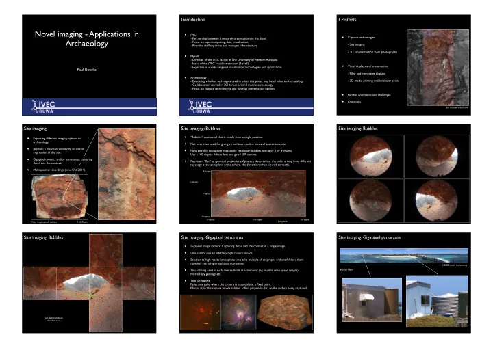
Site imaging: Bubbles
- “Bubbles” capture all that is visible from a single position.
- Not new, been used for giving virtual tours, online views of apartments, etc.
- Now possible to capture reasonable resolution bubbles with only 3 or 4 images.
Use a 180 degree fisheye lens and good SLR camera.
- Represent “flat” as spherical projections. Apparent distortion at the poles arising from different
topology between a plane and a sphere. No distortion when viewed correctly.
90 degrees
- 90 degrees
0 degrees
Latitude
0 degrees 180 degrees 360 degrees
Longitude
Site imaging: Bubbles Site imaging: Bubbles
Run demonstration
- f virtual tour
Site imaging: Gigapixel panorama
- Gigapixel image capture: Capturing detail and the context in a single image.
- One cannot buy an arbitrary high camera sensor.
- Solution to high resolution capture is to take multiple photographs and stitch/blend them
together into a high resolution composite.
- This is being used in such diverse fields as astronomy (eg: Hubble deep space images),
microscopy, geology, etc.
- Two categories
Panorama style: where the camera is essentially at a fixed point. Mosaic style: the camera moves relative (often perpendicular) to the surface being captured.
Site imaging: Gigapixel panorama
Beacon Island 120,000 pixels horizontally