Notes: GIS Applications in Fire Ecology & Management Lesson 7 - - PDF document

notes
SMART_READER_LITE
LIVE PREVIEW

Notes: GIS Applications in Fire Ecology & Management Lesson 7 - - PDF document

NR406 Notes: GIS Applications in Fire Ecology & Management Lesson 7 Understanding Landscape Dynam ics and VDDT Landscape succession disturbance dynamics in Sagebrush-Juniper Ecosystem s Bunting S.C., E.K. Strand and J.L. Kingery. 2005.


slide-1
SLIDE 1

NR406

GIS Applications in Fire Ecology & Management

Lesson 7 Understanding Landscape Dynam ics and VDDT

Landscape succession disturbance dynamics in Sagebrush-Juniper Ecosystem s

Bunting S.C., E.K. Strand and J.L. Kingery. 2005. Landscape characteristics of sagebrush steppe/juniper woodland mosaics under varying modeled prescribed fire regimes. Tall Timbers Fire Ecology Conference Proceedings, October 2005, Bartlesville, Oklahoma.

Notes:

NR406: GIS Applications in Fire Ecology and Management

Ow yhee Plateau in southw estern I daho Ow yhee Plateau in southw estern I daho

Notes:

The study are for this analysis encompasses 4 6th order watersheds on the Owyhee Plateau in southwestern Idaho. These watersheds are dominated by sagebrush steppe (Artemisia spp.) and western juniper (Juniperus occidentalis) vegetation at different successional stages. Infrequent components in the juniper dominated landscape are aspen stands, mountain riparian and rocky river canyons, ceanothus shrub fields and wet meadows. Altogether western juniper woodland dominates approximately 3.6 million ha in the northwestern portion of the Great Basin and southern Columbia Basin (Miller et al. 2005).

NR406: GIS Applications in Fire Ecology and Management

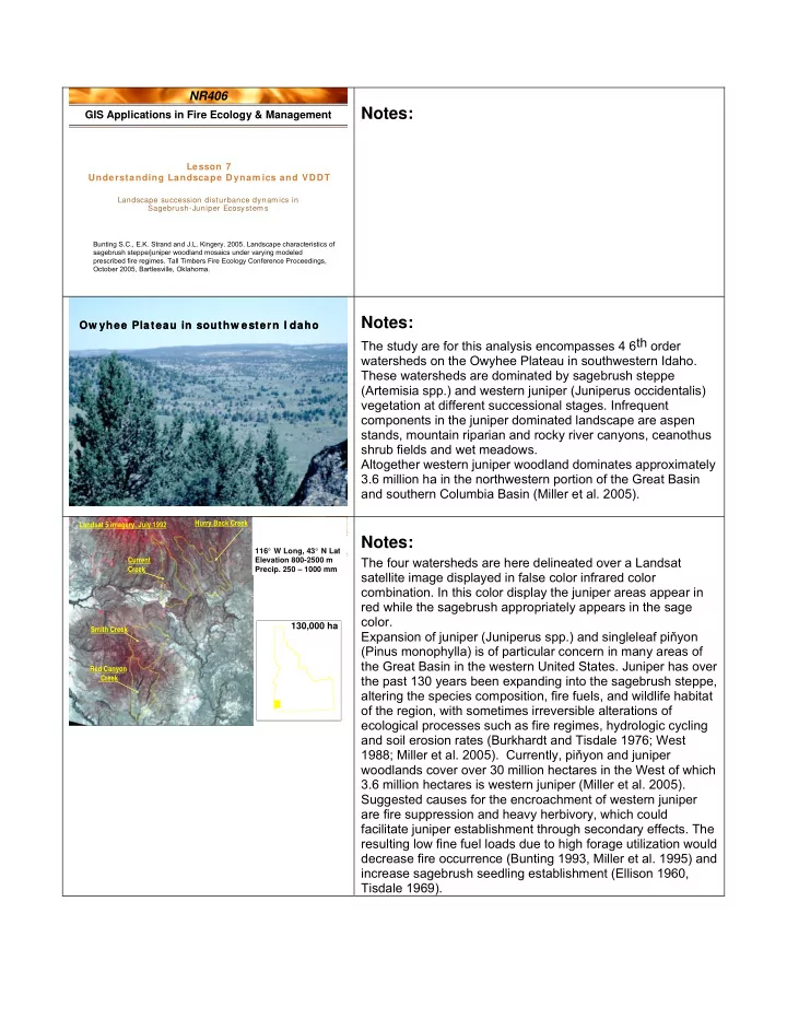
Landsat satellite im age Landsat satellite im age

Smith Creek Red Canyon Creek Current Creek Hurry Back Creek Landsat 5 imagery, July 1992

130,000 ha

116° W Long, 43° N Lat Elevation 800-2500 m

  • Precip. 250 – 1000 mm

Notes:

The four watersheds are here delineated over a Landsat satellite image displayed in false color infrared color

  • combination. In this color display the juniper areas appear in

red while the sagebrush appropriately appears in the sage color. Expansion of juniper (Juniperus spp.) and singleleaf piňyon (Pinus monophylla) is of particular concern in many areas of the Great Basin in the western United States. Juniper has over the past 130 years been expanding into the sagebrush steppe, altering the species composition, fire fuels, and wildlife habitat

  • f the region, with sometimes irreversible alterations of

ecological processes such as fire regimes, hydrologic cycling and soil erosion rates (Burkhardt and Tisdale 1976; West 1988; Miller et al. 2005). Currently, piňyon and juniper woodlands cover over 30 million hectares in the West of which 3.6 million hectares is western juniper (Miller et al. 2005). Suggested causes for the encroachment of western juniper are fire suppression and heavy herbivory, which could facilitate juniper establishment through secondary effects. The resulting low fine fuel loads due to high forage utilization would decrease fire occurrence (Bunting 1993, Miller et al. 1995) and increase sagebrush seedling establishment (Ellison 1960, Tisdale 1969).

slide-2
SLIDE 2

NR406: GIS Applications in Fire Ecology and Management

  • Herbland
  • Open shrubland
  • Closed shrubland
  • Stand initiation woodland (Phase I)
  • Young woodland (Phase II)
  • Mixed-age woodland (Phase III)
  • Mature woodland

Structural Stage Classification Structural Stage Classification

Notes:

A structural stage classification was developed along the sagebrush/juniper successional gradient with the following classes: herbland, open shrubland, closed shrubland, stand initiation woodland, young woodland, mixed-aged woodland, and mature woodland. The stand initiation woodland, young woodland, and mixed-aged woodland corresponds to a similar classification into phases presendted by Miller et al. (2005).

NR406: GIS Applications in Fire Ecology and Management

Grassland after fire Mountain big sagebrush steppe Stand initiation juniper (Phase 1) Open young juniper (Phase 2) Young multistory juniper (Phase 3) Mature juniper woodland

Succession in a W estern Juniper Com m unity Succession in a W estern Juniper Com m unity

Notes:

We mapped succession of western juniper in the four watersheds using aerial photography and classification of landsat imagery. Picture 1 shows grassland after a fire – the first successional stage Picture 2 shows the Sagebrush steppe stage Picture 3 shows the stand initiation juniper or Phase 1 according to Miller et al. (2005) Picture 4 shows the open young juniper or Phase 2 Change in understory cover (Bunting et al. 1999), species composition (Bunting et al. 1999, Miller et al. 2005) and fire behavior (Bunting, Yanish) begin to occur in this phase. Miller et al. (2005) has shown that these changes begin to

  • ccur at 15% juniper cover.

Picture 5 shows the young multistory juniper or phase 3 And Picture 6 shows the mature juniper woodland.

NR406: GIS Applications in Fire Ecology and Management

Sm ith Creek Cover Types Sm ith Creek Cover Types

Notes:

This is the structural stage map of one of the 4 watersheds, Smith Creek.

slide-3
SLIDE 3

NR406: GIS Applications in Fire Ecology and Management

  • Western juniper/ Mtn. big sagebrush/ Idaho

fescue

  • Western juniper/ Low sagebrush/ Idaho fescue
  • Western juniper-Curlleaf mtn.-

mahogany/ Mtn. snowberry Dom inant PVTs Dom inant PVTs

Notes:

The dominant potential vegetation types (habitat types) in the area are: Western juniper/Mtn. big sagebrush/Idaho fescue Western juniper/Low sagebrush/Idaho fescue Western juniper-Curlleaf mtn.-mahogany/Mtn. Snowberry

NR406: GIS Applications in Fire Ecology and Management

  • Low sagebrush
  • Chokecherry-Snowbrush
  • Aspen woodlands
  • Meadow and riparian

Other PVTs Other PVTs

Notes:

Less common vegetation types in the area are: Low sagebrush Chokecherry-Snowbrush Aspen woodland Meadow and riparian

NR406: GIS Applications in Fire Ecology and Management

Diagram for Western juniper / Mountain big sagebrush steppe

Herb Shrub Phase 1 A C B 1-10 yr 11-55 yr 56-75 yr (p = 0.02) (p = 0.02) Wildfire Wildfire Succession Fire transition Phase 2 Phase 3 Mature Wdland D E F 361 yr + 106-360 yr 76-105 yr (p = 0.01) (p = 0.002) (p = 0.001)

Vegetation Dynam ics Developm ent Tool – VDDT Vegetation Dynam ics Developm ent Tool – VDDT

Notes:

Succession for western juniper / mountain big sagebrush steppe is here displayed in a flow diagram. This type of flow diagram can be implemented in the computer simulation software VDDT (Vegetation Dynamics Development Tool) available from ESSA Technologies (http://www.essa.com/downloads/vddt/). VDDT is a Windows- based computer tool that provides a modeling framework for simulating the role of various disturbance agents and management actions in vegetation change. Each box in the diagram represent a stage in the juniper succession. Succession progress via a time-step function – green arrows. The red arrows represent a fire disturbance. Disturbance is modeled as stochastic functions, the probabilities for a disturbance are written on the red arrows (P=0.02 means that this transition will on average occur every 50 years, p=0.1 would mean every 10 years). In this simulation wildfire and prescribed fire are the only disturbances in our model. We calibrated the model by entering starting data from 100 years back in time and then ran the model forward to the present time. Input parameter were adjusted in such a way that we ended up with the present distribution of successional classes within the landscape.

slide-4
SLIDE 4

NR406: GIS Applications in Fire Ecology and Management

  • Successional classes for each PVT (habitat type)
  • Pathways and transition probabilities
  • Sets of probabilities can be defined to represent

different management regimes or ecological conditions

  • VDDT comes with a set of exam ple cover types,

structural stages and disturbance types, all defined in external files.

W hat does a user need to define? W hat does a user need to define?

Notes:

To run a succesional model in VDDT you need to define the following: 1) Successional classes for each PVT. PVT is here defined as the cover type that would occupy a site in the absence of any disturbance. In the juniper example we have 6 successional classes as described earlier. 2) Pathways and transition probabilities. The successional stages must be connected by succession or disturbance pathways – see our example in the previous slide. 3) Succession in VDDT works on a time step, i.e. after a fire the plant community will remain in a herbland for 10 years. There after the plant community will proceed to the next stage (VDDT box) and remain there for a certain time. See diagram on the last slide. The disturbance transitions occur based on probability. For example, if the average fire frequency in a juniper woodland is a fire every 100 years the probability of fire occurrence would be set to 0.01. These probabilities can be altered to play ‘what if’ games with the simulation. What if the fire probability increases from every 100 years (p=0.01) to every 50 years (p=0.02) what are the changes in landscape composition? 4) VDDT comes with a set of examples of PVT’s, cover types and structural stages. You can use these examples, modify them or create your own.

NR406: GIS Applications in Fire Ecology and Management

  • VDDT sim ulates the changes that occur within one

potential vegetation type (PVT).

  • A PVT is represented by a num ber of pixels, each

initially assigned an age and successional class (cover type and structural stage).

  • Using the pathways and probabilities defined for that

PVT, the model simulates the probability of each pixel being affected by one of the disturbance types, and if a disturbance does occur, moves the pixel to the appropriate class.

How does VDDT w ork? How does VDDT w ork?

Notes:

VDDT simulates the changes that occur within each PVT. A polygon cannot convert from one PVT to another, for example juniper woodland cannot convert to a wet meadow. Within PVT’s the landscape can change between the structural stages that are included in that PVT (6 stages in the juniper example). A PVT is represented by a number of pixels. Initially the user assigns the cover type and structural class to each pixel. This can be done based on current maps. If 10% of your landscape is in mature juniper you would assign 10% of the pixels to the mature juniper. The model moves each pixel to the appropriate cover/structure class based on the successional pathways and the disturbance probabilities.

slide-5
SLIDE 5

NR406: GIS Applications in Fire Ecology and Management

  • Disturbance probabilities depend only on the

current state of the pixel, defined by its successional class.

  • They are independent of the state of the

neighbouring pixels or the disturbance history. Thus, the model does not sim ulate contagion in space (e.g., wildfire) or time (e.g., insect

  • utbreaks).
  • The results from VDDT are not spatially explicit

and cannot be displayed in a map.

Note: Note:

Notes:

A few things to notice: The disturbance probabilities depend only on the current state

  • f the pixel defined by its successional class. The pixels are

independent of the surrounding pixels, ie the model does not simulate contagion. The results from VDDT are not spatially explicit and cannot be displayed in a map.

NR406: GIS Applications in Fire Ecology and Management

  • showing only certain pathways
  • adding or deleting pathways
  • change the probability or disturbance type for a

pathway (e.g. to simulate fire suppression policies)

  • disable some disturbances for the current simulation
  • change the initial pixel distribution between classes

(including using the ending results from a previous sim ulation or using the actual distribution in the landscape)

Options for probabilities or pathw ays: Options for probabilities or pathw ays:

Notes:

The VDDT diagrams can become very complex. To simplify the display you can hide selected pathways, for example only show succession pathways, or only show disturbance pathways related to fire. You can also make changes in the probabilities and pathways to simulate various scenarios. Modifications can be made to the initial pixel distribution between classes.

NR406: GIS Applications in Fire Ecology and Management

First three successional stages First three successional stages

Notes:

Each box (successional stage) in VDDT is represented by a

  • letter. In this slide you are looking at boxes A, B, and H. Within

each box you specify time spent in the particular successional stage, the disturbance pathways and the probability for each disturbance to occur. These screen captures are taken from the VDDT version 4.x. In the demonstration you will view later I use version 5.1 of VDDT where the pathway dialog boxes are in a slightly different format.

NR406: GIS Applications in Fire Ecology and Management

Output from VDDT – not spatially explicit Output from VDDT – not spatially explicit

Notes:

The output from VDDT is not spatially explicit (displayed in a map) but rather displayed in a sequence of bar graphs. Each bar shows the amount if the landscape that occupies a certain structural stage and cover class.

slide-6
SLIDE 6

NR406: GIS Applications in Fire Ecology and Management

Input data layers created using GIS Modeling in external computer programs VDDT and TELSA (or Landsum) Output linked to GIS layer for final analysis and display

VDDT and TELSA VDDT and TELSA

Notes:

Modeling in VDDT can be made spatially explicit with the help

  • f GIS and another simulation software called TELSA

(http://www.essa.com/downloads/telsa/index.htm). Input data layers are created using remote sensing and then converted into a GIS database. Each polygon (or pixel) in the input data is assigned a succesional stage according to the VDDT model. The succesional and disturbance pathways from VDDT are transferred into the TELSA software. The GIS database is the initial conditions in the succesional

  • model. TELSA then runs the simulation according to assigned

succession and disturbance pathways, time steps and

  • probabilities. The output from TELSA can be displayed in a

map format and results from different management scenarios can be compared.

NR406: GIS Applications in Fire Ecology and Management

  • The inputs to TELSA are PVT, cover and structure

maps in addition to the VDDT models.

  • TELSA models succession and disturbance for each

polygon in the data set.

  • The TELSA output is spatially explicit and can be

displayed in a GIS. TELSA – Tool for Exploratory Landscape Scenario Analyses TELSA – Tool for Exploratory Landscape Scenario Analyses

Notes:

TELSA stands for Tool for Exploratory Landscape Scenario Analyses (http://www.essa.com/downloads/telsa/index.htm). The inputs to TELSA are the PVT, cover and structure maps + the VDDT models. TELSA models succession and disturbance for each polygon in the dataset. The TELSA output can be displayed in map format.

NR406: GIS Applications in Fire Ecology and Management

Prescribed Fire in Phase 2 Prescribed Fire in Phase 2

Notes:

We modeled the sagebrush/juniper ecosystem 200 years in time for 5 different management scenarios. 1) Wildfire only 2) Prescribed fire where 2% of the watershed burned per decade (burns in phase1 and phase2 only) 3) Prescribed fire where 5% of the watershed burned per decade (burns in phase1 and phase2 only) 4) Prescribed fire where 7% of the watershed burned per decade (burns in phase1 and phase2 only) 5) Prescribed fire where 5% of the watershed burned per decade (burns in phase1, phase2, and phase3)

slide-7
SLIDE 7

NR406: GIS Applications in Fire Ecology and Management Watershed area (%) Present 50 yr 100 yr 200 yr Present 50 years 100 years 200 years

Grassland 0.7 0.9 1.3 1.5 Low sagebrush 4.4 3.9 4.0 3.9

  • Mtn. big sagebrush 1.4 3.2 2.2 2.3

Phase 1 0.3 4.3 2.1 1.1 Phase 2 19.9 11.6 3.3 0.7 Phase 3 34.4 53.4 58.0 47.2 Mature woodland 11.2 16.2 23.4 38.3 Mtn.-mahogany 2.6 2.6 1.5 1.4

Sm ith Creek W atershed- W ildfire only Sm ith Creek W atershed- W ildfire only

Notes:

These are maps of the landscape composition at present, 50 years, 100 years and 200 years under current wildfire

  • scenario. In general, darker colors represents more mature
  • juniper. As you can see, the current wildfire regime is not able

to maintain the sagebrush cover type. Succession moves the landscape towards mature juniper woodlands.

NR406: GIS Applications in Fire Ecology and Management

Present Wildfire 2% Rx 5% Rx 7% Rx 5% Rx including Phase 3

Sm ith Creek W atershed Com position after 1 0 0 years Sm ith Creek W atershed Com position after 1 0 0 years

Notes:

These maps show the landscape composition for the five different management scenarios 100 years from now. At lease 5% of the landscape needs to be treated with prescribed fire (or be allowed to burn in wildfire) to maintain the sagebrush steppe community types (sage colored polygons).

NR406: GIS Applications in Fire Ecology and Management

Grass/Forb 0.7 1.3 2.6 4.9 6.9 4.9 Low sage steppe 4.4 4.0 4.8 8.2 9.6 7.0 Mountain big sage steppe 1.4 2.2 4.2 10.8 13.8 10.7 Phase 1 20.3 2.1 6.4 8.4 7.8 11.5 Phase 2 19.9 3.3 2.9 2.0 1.0 3.5 Phase 3 34.4 58.0 50.1 36.7 32.2 37.4 Mature juniper woodland 11.2 23.4 23.6 23.5 23.3 19.9 Mountain-mahogany 2.6 1.5 0.5 0.1 0.0 0.5

Present Wildfire 2% Rx 5% Rx 7% Rx 5%Y Rx

...different fire scenarios

Watershed area (%)

Sm ith Creek - cover after 10 0 years Sm ith Creek - cover after 10 0 years

Notes:

This table shows the tabular data for the scenarios described

  • n the previous slide. Notice the percent of the landscape that

is in sagebrush cover types for the various scenarios.

NR406: GIS Applications in Fire Ecology and Management

Bunting S.C., E.K. Strand and J.L. Kingery. 2005. Landscape characteristics of sagebrush steppe/juniper woodland mosaics under varying modeled prescribed fire regimes. Tall Timbers Fire Ecology Conference Proceedings, October 2005, Bartlesville, Oklahoma.

Reading 7 Reading 7

Notes:

You next assignment is to read Reading 7. Lesson 8 – Fire Regime Condition Class – will build upon concepts learned in Lesson 7.