
SLIDE 1
Marshall Ranch Character Management Area Character Statement The - - PowerPoint PPT Presentation
Marshall Ranch Character Management Area Character Statement The boundaries of the Marshall Ranch CMA (Marshall Ranch) are defined by the Warm Springs Character Management map. Policies governing development of this area can be found within
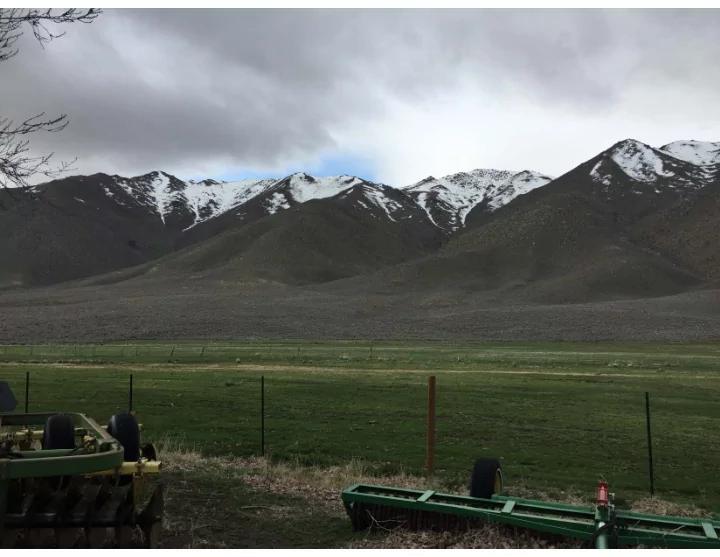
The boundaries of the Marshall Ranch CMA (Marshall Ranch) are defined by the Warm Springs Character Management map. Policies governing development of this area can be found within Appendix B of this document. The Marshall Ranch Property is unique in its setting, being nestled between the Dogskin Mountains to the southwest and the Virginia Mountains & Tule Peak to the northeast. This property forms the far northeastern boundary of the Warm Springs Area Plan and is accessed via Winnemucca Ranch Road. In 2017, the owners of the Marshall Ranch property recognized that the highest and best use of their ranch is large lots with maximum five-acre densities (one single family home per five acres) that preserves the scenic views of the adjoining mountains, wildlife corridors, and rural and agricultural character of the area while protecting the water resources and stream zone environments on the properties. Larger lots would provide a buffer between rural properties to the north, east, and south and the Spring Mountain property located to the west. Thus, the property owners took action to withdraw the Marshall Ranch from the City of Reno’s TMSA, which was approved by the Truckee Meadows Regional Planning Governing Board on October 26, 2017. Regardless of whether or not the Marshall Ranch Property is developed, it is in the best interest of the Warm Springs community to add additional development protections to the Marshall Ranch if it is developed within the Rural Development Area of the Truckee Meadows Regional Plan within Washoe County under the requirements of the Warm Springs Area Plan. Furthermore, the additional protections coupled with the ability to achieve development at a maximum density of one dwelling unit per five-acres will afford development opportunities in substantial conformance with the Goals and Policies of the Warm Springs Area Plan and the Truckee Meadows Regional Plan, while also encouraging conservation easements on the property. The previous Reno TMSA designation was an oxymoron given the current rural nature of the Marshall Ranch. This area is a remote, beautiful, and bucolic area within Washoe County, yet it is only a 45+/- minute drive from the system interchange of I-80 and I-580. Mountain peaks in the vicinity
Herds of mule deer and pronghorn antelope are known to frequent the area as their habitat includes much of the Virginia Mountains while portions
additional wildlife species as noted under the Wildlife and Wildlife Habitats section of the Warm Springs Area Plan.
The majority of land surrounding the Marshall Ranch are public lands, predominantly under the ownership of the Bureau of Land Management (BLM). Winnemucca Ranch Road provides convenient access to many popular recreation areas including the Moon Rocks Recreation area and the Bedell Flats area. Winnemucca Ranch Road is the primary access to the Marshall Ranch from Pyramid Hwy to the far northeast corner of the Warm Springs Area Plan. Winnemucca Ranch Road is paved up to Range Land Road (approximately 4.5 miles) where it turns into a seasonally maintained gravel road for the remainder of the Marshall Ranch access. Any future development on parcels smaller than 40 acres that is accessed by Winnemucca Ranch Road will require paving of Winnemucca Ranch Road. Paving the entirety of Winnemucca Ranch Road up to and through the Marshall Ranch should improve access to public lands currently accessed from the existing gravel portion of the road. In the winter and spring of 2017, an incredible amount of rain and snow fell on Washoe County, causing major damage to Winnemucca Ranch
the flow of the creek far exceeded the capacity of the culvert. This resulted in major downstream erosion, washing gravel, silt and debris downstream into the Warm Springs Valley. Future development should ensure that adequate capacity is made available for drainage features within and impacted by a project to help mitigate future flash floods and major storm damage. Letter of Map Revisions (LOMR) will be required with development to accurately characterize flood plain areas within the Marshall Ranch where flood zones exist. Wildfires are another major issue in this area. In 2018, a major fire started near Herlong at US 395 and burned through Winnemucca Valley and far up the hillsides of the Dogskin and Virginia Mountains. Helicopters used to fight the fires used their pumps to suction water out of a large pond
property with perhaps the exception of the ponds, should be considered in any future development plans. As the Marshall Ranch remains largely undeveloped, residents of the Warm Spring Planning area, the North Valleys area, and numerous Truckee Meadows residents and tourists are discovering the peace, tranquility, and dark skies that this area affords. There will be increasing pressure from citizens to maintain public access as this area is discovered thus increasing the need for any future development to occur in a manner that respects the character of this area. In order to maintain the dark sky character of the area, future development should be required to mitigate uses with the potential light pollution impacts and use all Dark Sky certified and fully shielded lighting. Both street and building lighting should only be used for safety purposes and motions sensors should be encouraged to activate the lights during late night hours to help preserve and maintain the area’s dark skies. The vision of this character management statement is to further the policies and protections of the Warm Springs Area Plan, while protecting private property rights, and to work to preserve the wildlife corridors, wildlife habitat, scenic beauty and vistas, rural lifestyle, existing agricultural activities, native vegetation, and water resources as any future development occurs.
Within the Marshall Ranch Character Management Area industrial and commercial development will not be allowed. Only large lot residential uses at a maximum density of one dwelling unit per 5-acres acre will be allowed within the Marshall Ranch Character Management Area. The minimum allowed lot size will be 5-acres and no clustering or density transfers will be allowed. To protect the unique qualities present within the Marshall Ranch Character Management Area, future development activities should be conducted in a manner that maintains open space and scenic views and provides connections to existing and planned public roads and trails
Department that will serve a dual purpose of providing access to open space within developed areas and to public lands while minimizing impacts to wildlife. Developers should work with the Nevada Division of Wildlife and county staff to develop a wildlife mitigation plan to ensure that adequate wildlife corridors are maintained for mule deer and pronghorn antelope. The plan should also consider other wildlife species including bighorn sheep, sage grouse, and other upland and migratory bird species. Property owners on the Marshall Ranch who farm, ranch, and run cattle may continue to do so and any future development should be highly respectful of these private property rights and design their development to minimize the impacts of the residential and agricultural interfaces. Good fencing makes for good neighbors and high-quality fencing should be used along with cattle guards that only restrict access of livestock into developed properties and not public lands. County policies supporting and facilitating a rural approach to the maintenance of animals including livestock, hobby livestock, and pets will contribute to the preservation of the area’s character. The threat of periodic natural hazards including floods, avalanche, earthquakes and wildland fires are a danger in much of the Marshall Ranch Character Management Area. Washoe County should continue to work in close collaboration with other agencies to reduce these threats through the application of development standards, hazard mitigation, emergency management practices, and educational programs. Prolonged droughts that occur on a regular basis and over utilization of permitted water rights within the Warm Springs Planning Area has resulted in a drawdown of the main aquifers associated with this area. The sustainable management of the area’s water resources is necessary to maintain the quality of these aquifers. Development of the Marshall Ranch should meet or exceed the strict sustainability requirements of the Water Budget contained in appendix A of the Warm Springs Area Plan including any updates to the water budget. New development activities should be planned and conducted in such a manner as to enhance water recharge, fully utilize treated wastewater, and minimize the amount of water required for landscaping and amenities. Due to the Marshall Ranch’s function as a gateway to and from public lands and recreation areas, its key natural assets, and its ability to contribute to the Conservation goals of the plan, the Warm Springs Area Plan’s unique and valuable character is carefully managed and preserved through the thoughtful and deliberate implementation of the goals and policies specific to the Marshall Ranch Character Management Area. In addition, all other goals and policies of the Warm Springs Area Plan also apply to the character management area.
(L) View from west end of Marshall Ranch – looking west (R) View from Marshall Ranch Pasture Area – looking south (L) Downstream damage to creek from washed out culvert (R) Moon Rocks
WS.B.1 When feasible, given utility access constraints, grading for development purposes after the date of final adoption of this plan will:
developer/applicant shall be required to obtain a dust control permit. WS.B.2 Site development plans in the Marshall Ranch CMA must submit a plan for the control of noxious weeds. The plan should be developed through consultation with the Washoe County District Health Department, the University of Nevada Cooperative Extension, and/or the Washoe-Storey Conservation District. The control plan will be implemented on a voluntary compliance basis and shall include both eradication of noxious weeds and reseeding with native grasses and plants. WS.B.3 Applicants required to present their items to the Citizen Advisory Board (CAB) must submit a statement to staff regarding how the final proposal responds to the community input received from the CAB. WS.B.4 All lighting must be “dark-sky” certified. The use of streetlights will be minimized and lighting shall be used only for safety
used on building and parking lot lighting such that lights shall only be on from the hours of 11:00 pm to dusk when activated by motion sensors. WS.B.5 All landscape designs will emphasize the use of native and low water requirement vegetation, with non-native and atypical vegetation integrated sparingly into any landscaped area. Fire resistant landscaping is desirable, especially in clear zones around structures. WS.B.6 Development activities should be designed to support the efficient use of infrastructure and the conservation of recharge areas, wetland areas, wildlife habitat areas, wildlife corridors, and open vistas. Prior to submitting any tentative map, special use permit
mitigation plan acceptable to NDOW to maintain wildlife corridors for mule deer and pronghorn antelope adequate to allow them to move between their natural habitat and winter habitat areas. The plan shall also address bighorn sheep, sage grouse, and other upland and migratory bird species. This plan shall be included with all discretionary applications, and Washoe County staff shall establish the implementation measures as conditions of approval. WS.B.7 Prior to submitting any tentative map, special use permit or other discretionary application, the developer shall consult with the U.S. Fish & Wildlife Service (USFWS) to address their concerns regarding potential direct and indirect impacts to the Carson Wandering Skipper, a butterfly classified as an endangered species. The applicant shall work with the USFWS to create a plan acceptable to USFWS addressing requirements of the Endangered Species Act in relation to the Skipper. WS.B.8 A community water system shall be required with development to provide water service for the project with conceptual plans to be submitted with a tentative map application. The community water system shall be approved by the Washoe County Health District prior to approval of any final map. The community water system shall be approved by the Public Utility Commission of the State of Nevada (PUCN) and the developer shall obtain necessary certificates of operation from the PUCN prior to approval
each on an individual 5-acre minimum size lot may use a water well in accordance with County requirements. WS.B.9 Washoe County is working with regional partners to ensure best practices for wildland fire prevention and management are used for development activities in the wildland suburban interface. Applications for any discretionary approval must show how their project will manage the potential threat of wildland fire in accordance with adopted codes. Plans that propose the use of defensible space must include a maintenance plan for that space that demonstrates how that area will be maintained and managed for the life of the project. WS.B.10 A recreational trail system shall be planned in conjunction with Washoe County Parks staff that will serve a dual purpose of providing access to open space within the development and to public lands while minimizing impacts to wildlife. The recreational trail system shall be approved by County staff prior to approval of any tentative map for a project and conditioned by Washoe County staff to be constructed in phases with development prior to issuance of any Certificate of Occupancy. WS.B.11 Development shall maintain access to all public roads and trails to the satisfaction of County staff. Drainage features both within a project and impacted by the project shall be designed and constructed in accordance with current County requirements to convey the 100-year storm and minimize flood impacts to public and private roads and trails. All roads within and serving the development shall be constructed or improved to Washoe County standards including paving of Winnemucca Ranch Road to its
current paved terminus at Range Land Road prior to the issuance of any Certificate of Occupancy, or as required by the County Engineer during tentative map review. WS.B.12 A traffic study shall be submitted with any Tentative Map application(s) with a scope of work approved by the County traffic engineer and shall include an analysis of the intersection of Winnemucca Ranch Road with the Pyramid Highway. Improvements at a minimum shall include a northbound to westbound left turn pocket and any other improvements as required by the Nevada Department of Transportation. The traffic study should also determine the amount of traffic that is likely to use Range Land Road based on existing traffic patterns in the area. If more than 10% of project traffic is estimated to use Range Land Road, then a chip seal surface treatment shall be applied to Range Land Road from Winnemucca Ranch Road to the Pyramid Highway in accordance with Washoe County requirements and best industry practices prior to issuance of the first Certificate of Occupancy for the project. WS.B.13 The following Regulatory Zones are permitted within the Marshall Ranch Character Management Area of the Warm Springs planning area.
transfers are allowed.
WS.B.14 Significant portions of the CMA are subject to the standards of Washoe County Development Code Article 424, Hillside
requirements of the article, and a site analysis prepared by a qualified engineer shall be submitted to address hillside development standards. In order to reduce the visual impact of development in these areas, grading shall work with and complement the natural terrain and contours and minimize impacts to the natural topography. Graded slopes shall be revegetated with either native plants or other species that are deemed desirable for the area that match the height of surrounding species and are fire resistant.
WS.B.15 During review of tentative maps and other development proposals, County staff will review the adequacy of the minimum standards established under this plan; and upon a finding that a standard is inadequate to implement these goals, may recommend to the Planning Commission other similar standards as necessary to implement the relevant goal. WS.B.16 The standards established in policies WS.B.1-WS.B.14 will be implemented through tentative map conditions, improvements plans, CC&Rs, deed restrictions, or other methods deemed as appropriate by the Director of Planning & Building. When appropriate, Washoe County staff shall establish the implementation measures as conditions of tentative map approval.