
SLIDE 1
! ( ! ( ! ( ! ( ! ( ! ( ! ( ! (
CoKPLN100316lk
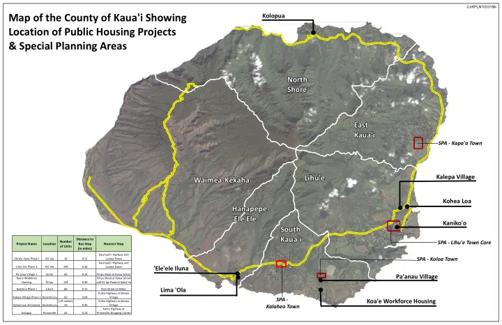
Map of the County of Kaua'i Showing Location of Public Housing Projects & Special Planning Areas
'Ele'ele Iluna Lima 'Ola Koa'e Workforce Housing Pa'anau Village Kaniko'o Kohea Loa Kalepa Village Kolopua
Waimea-Kekaha Hanapepe- 'Ele'Ele South Kaua'i Lihu'e East Kaua'i North Shore
SPA - Kapa'a Town SPA - Kalaheo Town SPA - Koloa Town SPA - Lihu'e Town Core
Project Name Location Number
- f Units
Ele'ele Iluna Phase I Ele'ele 18 Lima Ola Phase 1 Ele'ele 149 Pa'anau Village 1 Koloa 60 Koa'e Workforce Housing Po'ipu 134 Kaniko'o Phase I Lihu'e 60 Kalepa Village Phase I Hanama'ulu 60 Kohea Loa, Ho'oluana Hanama'ulu 119 market, 32 Kolopua Princeville 44 Po'ipu Road at Koloa School
Nearest Stop Distance to Bus Stop (in miles)
0.24 0.15 Rice Street at Midas 0.24 Kuhio Highway at Princeville Shopping Center 0.46 Po'ipu Road at Koloa School and Po'ipu Road at Kukui'ila 0.09 Kuhio Highway at Kalepa Village 0.21 Kaumuali'i Highway and Laulea Street 0.36 Kaumuali'i Highway and Laulea Street 0.45 Kuhio Highway at Kalepa Village