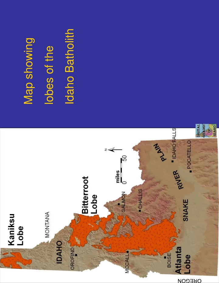
SLIDE 1
Map showing lobes of the Idaho Batholith
SLIDE 2
Geologic map of parts of Blaine and Custer Counties. Shows cross section from batholith east through core complex to thrust belt.
SLIDE 3 Sawtooth Valley, view to northwest from Galena Summit. The jagged peaks in the north part of the view are in the Eocene Sawtooth batholith. The more gentle peaks south of the prominent glacial lake (Alturas Lake) in center of view are cut from Cretaceous granodiorite of the Idaho
- batholith. The sculpted hill in foreground is made of glacial debris.
SLIDE 4 Aerial view of Idaho batholith flying from Boise to Pocatello. Note the concordant summit surface, likely of Miocene age, and predating uplift of the batholith. The river is the south fork of the Boise
- River. View is to the north.
SLIDE 5 Castle Peak in the White Cloud Mountains. Peak is underlain by gray granodiorite of the Idaho
- batholith. White rocks on the right are baked impure limestone of the Permian Grand Prize
Formation, intruded by the Cretaceous granodiorite. View is to north from north of 4th of July Creek.
SLIDE 6
View of White Cloud Mountains from Washington Basin. Dark bedded rocks in foreground are Permian Grand Prize Formation. Low knobby hills in distance are underlain by Idaho batholith.
SLIDE 7
Buttercup Mountain in the southern Smoky Mountains north of Fairfield. The mountain is underlain by Cretaceous Idaho batholith. Rocks in foothills are Pennsylvanian and Permian Dollarhide Formations.
SLIDE 8
View of South Fork of Boise River and placer workings at Placerville. Rocks are Cretaceous Idaho batholith, mostly.
SLIDE 9
Yankee Fork dredge. This devise mined for placer gold in Yankee Fork of Salmon River until about 1955. Tours are still available.
SLIDE 10
Middle Fork Boise River at Lightfoot Hot Springs, Atlanta Lobe Idaho batholith, photo by Reed Lewis.
SLIDE 11
Jointing in granite with apparent human figure, Jim Cash photo.
SLIDE 12
Glacial valley and cirque of Canteen Creek, Bitterroot Lobe, Idaho batholith.
SLIDE 13
Glacially polished granodiorite, Slater Meadows.
SLIDE 14
Lochsa River, looking up canyon, Bitterroot Lobe, Idaho batholith, Hwy 12, mp 116.
SLIDE 15
Selway Falls, Selway River, Bitterroot Lobe, Idaho batholith.
SLIDE 16
Coolwater Creek orthogneiss, Lochsa River, Highway 12, Clearwater Mountains.
SLIDE 17 Biotite granodiorite, Soldier Mountains. Yellow stained mineral is pink potassium
- feldspar. White feldspar is plagioclase. Quartz looks gray.
SLIDE 18
Cretaceous Biotite granodiorite, crossed polars. Megacrysts of potassium feldspar with inclusions.
SLIDE 19
Biotite granodiorite, Bitterroot Lobe, Idaho batholith.
SLIDE 20
Megacrystic granodiorite, Glade Creek, Bitterroot Lobe. Note zoning of megacrysts.
SLIDE 21
Foliated Cretaceous hornblende biotite granodiorite.
SLIDE 22
Gneiss (metamorphosed Belt Supergroup?), margin of Bitterroot Lobe, Idaho batholith.
SLIDE 23
Foliated xenolith in granodiorite, mp 151, Highway 12, Lochsa River.
SLIDE 24
Mafic dike cutting Idaho batholith. Dike may be related to Challis or Columbia River basalt magmatism.
SLIDE 25
West Mountain, view to north of Cascade Reservoir and Long Valley.
SLIDE 26
Granodiorite, east side of West Mountain, west of Cascade.
SLIDE 27
Gneiss on margin of Bitterroot Lobe, Clearwater Mountains.
SLIDE 28
Foliated Cretaceous granodiorite, above Horse Creek, western border zone of batholith. Note boudinage of felsic minerals.
SLIDE 29 Foliated Jurassic diorite at Dworshak Dam visitors center, just east
zone.
SLIDE 30
Tonalite, mp 84, Highway 12, Clearwater River.
SLIDE 31 Kent Peak from trailhead to TwoMouth Lakes, Selkirk Mountains, Cretaceous Kaniksu
- batholith. Note exfolation of glaciated granitic dome.
SLIDE 32
Joe’s Lake Cirque, Selkirk Mountains, Cretaceous granodiorite.