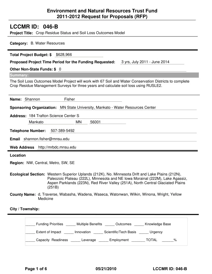
lccmr id 046 b
play

LCCMR ID: 046-B Project Title: Crop Residue Status and Soil Loss - PDF document

Environment and Natural Resources Trust Fund 2011-2012 Request for Proposals (RFP) LCCMR ID: 046-B Project Title: Crop Residue Status and Soil Loss Outcomes Model Category: B. Water Resources Total Project Budget: $ $628,966 Proposed


  1. Environment and Natural Resources Trust Fund 2011-2012 Request for Proposals (RFP) LCCMR ID: 046-B Project Title: Crop Residue Status and Soil Loss Outcomes Model Category: B. Water Resources Total Project Budget: $ $628,966 Proposed Project Time Period for the Funding Requested: 3 yrs, July 2011 - June 2014 Other Non-State Funds: $ 0 Summary: The Soil Loss Outcomes Model Project will work with 67 Soil and Water Conservation Districts to complete Crop Residue Management Surveys for three years and calculate soil loss using RUSLE2. Shannon Fisher Name: MN State University, Mankato - Water Resources Center Sponsoring Organization: 184 Trafton Science Center S Address: Mankato MN 56001 507-389-5492 Telephone Number: shannon.fisher@mnsu.edu Email http://mrbdc.mnsu.edu Web Address Location NW, Central, Metro, SW, SE Region: Ecological Section: Western Superior Uplands (212K), No. Minnesota Drift and Lake Plains (212N), Paleozoic Plateau (222L), Minnesota and NE Iowa Morainal (222M), Lake Agassiz, Aspen Parklands (223N), Red River Valley (251A), North Central Glaciated Plains (251B) d, Traverse, Wabasha, Wadena, Waseca, Watonwan, Wilkin, Winona, Wright, Yellow County Name: Medicine City / Township: _____ Funding Priorities _____ Multiple Benefits _____ Outcomes _____ Knowledge Base _____ Extent of Impact _____ Innovation _____ Scientific/Tech Basis _____ Urgency _____ Capacity Readiness _____ Leverage _____ Employment _______ TOTAL ______% Page 1 of 6 05/21/2010 LCCMR ID: 046-B

  2. PROJECT TITLE: Crop Residue Status and Soil Loss Outcomes Model I. PROJECT STATEMENT Keeping productive soil on the land and out of the water is one of Minnesota’s primary conservation goals. The counties, state and federal government administer a variety of programs that work together to help landowners reduce soil erosion to tolerable (“T”) levels or below. Many TMDL implementation plans also call for practices that reduce sediment transport; however, opportunities to evaluate outcomes and measure success are rare. Since the 1980s, landowners have made strides toward conserving productive soil on the land through the use of numerous soil conservation techniques. The transect survey is a statistical method for estimating cropland soil erosion based on a visual examination of field conditions. It is currently one of the few practices that can readily be assessed for soil loss reductions; however, the right evaluation tools and data collection protocols must be in place. The 2007 Tillage Transect Survey (TTS), also referred to as Crop Residue Management Surveys, represents the first electronically available resource for residue data in Minnesota and has facilitated the evaluation of residue data not only by county, but by watershed as well. The Tillage Transect Survey Project will work with 67 Soil and Water Conservation Districts (SWCD) and/or Watersheds to complete Tillage Transect Surveys of their counties for three consecutive years. Via modification of a Wisconsin–based model, the Water Resources Center is ready to finish program development (modification of Wisconsin Tillage Transect Program), work with SWCD’s and other local partners to obtain three consecutive years of data, and deliver credible outcomes that relate land use practices to water quality. The overall goal of this project is improve on previous tillage transect surveys and provide a better mechanism to conduct the survey as well as report the results of the survey quickly. The overall goal will be strengthened by the following project goals. 1. Track the crop residue management practices throughout Minnesota and determine if improved tillage practices have an effect on soil loss. 2. Collect Tillage Transect data for three consecutive seasons based on new parameters tied to the RUSLE2 program and be able to calculate soil loss for the 32,000 points. 3. Create repository for Transect Data that will allow for one central location to analyze the data over three years and for any future surveys completed after the project. 4. Assess and report on data to determine soil loss in Minnesota by county, watershed, basin and statewide as well as any other geographic region. The project will achieve these goals through the implementation of the new Minnesota WinTransect Program that will be used as a tool for collection of Tillage Transect data in the field. WinTransect is a program that utilizes soil data and climate zone data along with the transect information collected to calculate a soil loss component for each of the 32,000 stops. WinTransect allows for data collection in the field that is readily available. The point data is stored in one compact database and can be used yearly. Analysis and Reports are available immediately compared to many months to a year in previous tillage transect surveys. II. DESCRIPTION OF PROJECT ACTIVITIES Activity 1: WinTransect Development and Route Adjustment Budget: $36,313.00 Develop WinTransect Program and data collection protocols for new Tillage Transect Surveys and conduct GIS analysis/adjustment of transect routes to provide better survey coverage. Outcome Completion Date 1. Modify Wisconsin Program/GIS Route Analysis and Adjustment January 2012 Activity 2: Quality Control and Protocol Training Budget: $59,220.00 Develop and implement training sessions for viewers to provide quality control and overview protocols for consistent and standardized data across Minnesota- Page 2 of 6 05/21/2010 LCCMR ID: 046-B

  3. Outcome Completion Date 1. Coordinate and Implement Training Sessions for SWCD/Watersheds April 2012 Activity 3: Tillage Transect Survey Data Collection Budget: $448,595.00 Coordinate SWCD/Watershed Data Collection and manage data, including quality control and quality assurance checks over the three consecutive years. Outcome Completion Date 1. Completion of Tillage Transect Survey and Prepare Annual Report July 2012 2. Completion of Tillage Transect Survey and Prepare Annual Report July 2013 3. Completion of Tillage Transect Survey and Prepare Annual Report July 2014 Activity 4: Assessment of Soil Loss Data Results Budget: $46,467.00 Finalize Data and Assess Soil Loss Data Results on Several Scales, including an Assessment on Nutrient Relationships- Tillage Practices will be reported yearly following the survey. Outcome Completion Date 1. Assess Soil Loss Data Results and Analyze Data for Trends September 2014 Activity 5: Soil Loss Data Results and Report Budget: $38,371.00 Present Results to Interested Stakeholders and Government Staff, including Collection of Feedback from Participants as well as a Final Report- Outcome Completion Date 1. Prepare Report of Soil Loss from Data and Creation of Final Report. September 2014 III. PROJECT STRATEGY A. Project Team/Partners Water Resources Center Staff (Project Team) : Shannon Fisher, Director – project manager, develop protocol, deliver training sessions. Personnel - ($43,996 – 0.15 FTE for 3 years) Rick Moore, GIS Specialist – development of WinTransect Program, Route analysis and route adjustment, Collect data from supporting Soil and Water Conservation District’s (SWCD)/ Watersheds, analyze data. Personnel – ($131,526 – 0.5 FTE for three years) Office Support Staff – Other State $ being applied to Project ($3,000) – Secured from MSU - Mankato SWCD/Watershed Staff (Project Team) (67 counties with >30% cropland) – Attend preliminary and follow up Training Sessions – In-kind Services (67 people for 1 day each@$25/hr = $13,400), Viewer prep time in the office – In-kind Services (67 people for 1/2 day @$25/hr per year = $20,100), Conduct Tillage Transect Surveys each May/June – Contract Work - (67 SWCD - $2,100/year for 3 years = $422,100). Paul Kaarakka – University of Wisconsin Soils Science Software Programmer (Project Team) – WinTransect Program Development and Corresponding Soil and Climate Data Development. Contract Work – (2 months @ $7,500/month = $15,000) Minnesota River Board (Partner) – Pending Grant Application for Projects – ($3,000) – In-Kind Services – MN River Board Director Admin contributions (5 days/year at $527/day = $7,905) B. Timeline Requirements The data for the first two years would just show the tillage practices and crops. In the third year of the program, actual soil loss calculations would be able to be run. To calculate soil loss, RUSLE2 calculations are run for a single year with 2 years “lead-in” to avoid the effects of RUSLE2 starting it’s modeling from bare soil. Therefore, because of this requirement for RUSLE2, soil loss calculations would not be reported until year three. Transects will be completed in May/June of 2012, 2013, and 2014. Analysis of data would be ongoing and occur immediately after the last transect in 2014 with time needed to analyze and produce reports. C. Long-Term Strategy and Future Funding Needs The long term application of this project is evident as we try to assess our success in reducing sediment transport to our rivers, lakes and streams. If funded, this project would be an ongoing project to collect tillage transect data and report on tillage practices within the state. Page 3 of 6 05/21/2010 LCCMR ID: 046-B

Download Presentation
Download Policy: The content available on the website is offered to you 'AS IS' for your personal information and use only. It cannot be commercialized, licensed, or distributed on other websites without prior consent from the author. To download a presentation, simply click this link. If you encounter any difficulties during the download process, it's possible that the publisher has removed the file from their server.

Recommend


More recommend