Information Technology Group #2 Information Technology Group #2 IT - - PDF document

information technology group 2 information technology
SMART_READER_LITE
LIVE PREVIEW

Information Technology Group #2 Information Technology Group #2 IT - - PDF document

2/13/2012 Information Technology Group #2 Information Technology Group #2 IT GROUP #2--8 PROJECTS (30 Minutes) Leader: Ron Eguchi Japan & NZ US Caverlee, James Texas A&M University RAPID: Earthquake Damage Assessment from Social


slide-1
SLIDE 1

2/13/2012 1

Information Technology Group #2

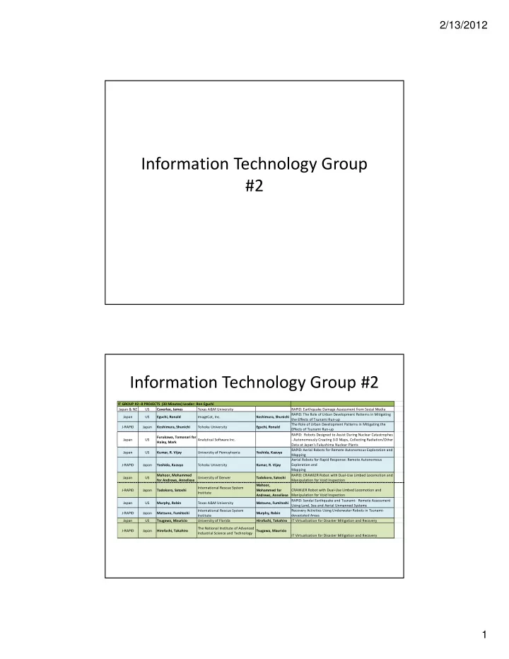
Japan & NZ US Caverlee, James Texas A&M University RAPID: Earthquake Damage Assessment from Social Media Japan US Eguchi, Ronald ImageCat, Inc. Koshimura, Shunichi RAPID: The Role of Urban Development Patterns in Mitigating the Effects of Tsunami Run-up J-RAPID Japan Koshimura, Shunichi Tohoku University Eguchi, Ronald The Role of Urban Development Patterns in Mitigating the Effects of Tsunami Run-up Japan US Furukawa, Tomonari for Haley, Mark Analytical Software Inc. RAPID: Robots Designed to Assist During Nuclear Catastrophes

  • Autonomously Creating 3-D Maps, Collecting Radiation/Other

Data at Japan's Fukushima Nuclear Plants Japan US Kumar, R. Vijay University of Pennsylvania Yoshida, Kazuya RAPID: Aerial Robots for Remote Autonomous Exploration and Mapping J-RAPID Japan Yoshida, Kazuya Tohoku University Kumar, R. Vijay Aerial Robots for Rapid Response: Remote Autonomous Exploration and Mapping Japan US Mahoor, Mohammed for Andrews, Anneliese University of Denver Tadokoro, Satoshi RAPID: CRAWLER Robot with Dual-Use Limbed Locomotion and Manipulation for Void Inspection J-RAPID Japan Tadokoro, Satoshi International Rescue System Institute Mahoor, Mohammed for Andrews, Anneliese CRAWLER Robot with Dual-Use Limbed Locomotion and Manipulation for Void Inspection Japan US Murphy, Robin Texas A&M University Matsuno, Fumitoshi RAPID: Sendai Earthquake and Tsunami- Remote Assessment Using Land, Sea and Aerial Unmanned Systems J-RAPID Japan Matsuno, Fumitoshi International Rescue System Institute Murphy, Robin Recovery Activities Using Underwater Robots in Tsunami- devastated Areas Japan US Tsugawa, Mauricio University of Florida Hirofuchi, Takahiro IT Virtualization for Disaster Mitigation and Recovery J-RAPID Japan Hirofuchi, Takahiro The National Institute of Advanced Industrial Science and Technology Tsugawa, Mauricio IT Virtualization for Disaster Mitigation and Recovery IT GROUP #2--8 PROJECTS (30 Minutes) Leader: Ron Eguchi

Information Technology Group #2

slide-2
SLIDE 2

2/13/2012 2

Situational Awareness

Emergency Response Community Damage Assessment Remote Sensing Crowdsourcing Social Media Robust Communications Virtual Machines Situational Awareness under Hazardous Conditions Robotics Unmanned Vehicles

Community Damage Assessment

Emergency Response Community Damage Assessment Remote Sensing Crowdsourcing Social Media Robust Communications Virtual Machines Damage Analysis under Hazardous Conditions Robotics Unmanned Vehicles

  • Caverlee, TAMU – Earthquake

Damage Assessment from Social Media

  • Eguchi, ImageCat & Koshimura,

Tohoku University – The Role of Urban Development Patterns in Mitigating the Effects of Tsunami Run-up

slide-3
SLIDE 3

2/13/2012 3

Earthquake Damage Assessment from Social Media

Japan and NZ Earthquakes RAPID and Research Needs Workshop Arlington, VA Feb 9 and 10, 2012

  • Objective: Assess,

characterize, and model earthquake damage using GPS-labeled social media posted in the minutes and hours post- emergency James Caverlee (Computer Science) John Mander (Civil Engineering) Texas A&M University

Twitter-based “intensity”

Key Findings

  • Spatial density of all social media posts is consistent

with shaking intensity trend (compared to isoseismal map)

  • Surprisingly, density of social media posts including

photos is highest in seriously-damaged areas, indicating capacity of images for rapid damage assessment

Japan and NZ Earthquakes RAPID and Research Needs Workshop Arlington, VA Feb 9 and 10, 2012

slide-4
SLIDE 4

2/13/2012 4

The Role of Urban Development Patterns in Mitigating the Effects of Tsunami Run-up

Japan and NZ Earthquakes RAPID and Research Needs Workshop Arlington, VA Feb 9 and 10, 2012

Purpose of RAPID Grant: to understand the relationship between urban development patterns and the extent of physical damage caused by widespread tsunami run-up. Technologies & data used:

  • Remote-sensing image analysis of pre & post-

earthquake data

  • Crowdsourcing techniques for scalable analysis
  • f the large imagery datasets
  • Tsunami simulation models to scale community

results to larger areas or regions.

  • Interaction of demographic and social

characteristics with the built environment to produce safety or mortality in the earthquake and tsunami.

  • US

– Ronald T. Eguchi – John Bevington – Albert Lin – James D. Goltz, Consultant

  • Japan

– Fumio Yamazaki – Shunichi Koshimura – Masashi Matsuoka

Key Findings

The data collected so far indicates

that certain neighborhood configurations can offer some protection to community residents (e.g., parts of Ishinomaki that were located behind large, coastal wharf structures) while other configurations can actually enhance damage and impacts (e.g., Onagawa). Ground survey data are needed in

  • rder to fully characterize the extent
  • f building damage, i.e., much

damage is missed by only using remote sensing imagery.

Onagawa

Before After

Protected

Ishinomaki

Not Protected

Red - Destroyed

Japan and NZ Earthquakes RAPID and Research Needs Workshop Arlington, VA Feb 9 and 10, 2012

Community-based fragility curves have been developed

slide-5
SLIDE 5

2/13/2012 5

Situational Awareness under Hazardous Conditions

Emergency Response Community Damage Assessment Remote Sensing Crowdsourcing Social Media Robust Communications Virtual Machines Situation Awareness under Hazardous Conditions Robotics Unmanned Vehicles

  • Furukawa, Analytical Software, Inc. – Robots

Designed to Assist during Nuclear Catastrophes – Autonomously creating 3-D Maps, Collecting Radiation/Other Data at Japan’s Fukushima Nuclear Plants

  • Kumar, University of Pennsylvania & Yoshida,

Tohoku University – Aerial Robots for Remote Autonomous Exploration and Mapping

  • Mahoor, University of Denver & Tadokoro,

International Rescue System Institute, Crawler Robot with Dual-Use Limbed Locomotion and Manipulation for Void Inspection

  • Murphy, Texas A&M & Matsuno - Sendai

Earthquake and Tsunami – Remote Assessment using Land, Sea and Aerial Unmanned Systems; Recovery Activities using Underwater Robots in Tsunami-devastated Areas

Enhanced capabilities for Fukushima-type Rescue Robots

Japan and NZ Earthquakes RAPID and Research Needs Workshop Arlington, VA Feb 9 and 10, 2012

– RAPID Title: Robots designed to assist during Nuclear Catastrophes - Autonomously creating 3- D Maps, Collecting Radiation/other data at Nuclear Power Plants such as at Fukushima – Mark Haley, President, Analytical Software Inc., TX – Professor Kenzo Nonami and Professor Mark Haley, Chiba University, Japan – Added autonomous capabilities for iRobot’s Packbot, main robot currently operating inside Fukushima

slide-6
SLIDE 6

2/13/2012 6

Key Findings

  • Autonomous Capabilities are key for Fukushima-

type rescue robots - Real-time 3D SLAM and other technologies which reduce manual operations are crucial for rescue robots.

  • Research focused on adding capabilities to iRobot’s

Packbot, main robot currently operating inside

  • Fukushima. Japan. In high profile disasters it is

risky to use untested technology in the field.

Japan and NZ Earthquakes RAPID and Research Needs Workshop Arlington, VA Feb 9 and 10, 2012

RAPID: Aerial Robots for Remote Autonomous Exploration and Mapping

Japan and NZ Earthquakes RAPID and Research Needs Workshop Arlington, VA Feb 9 and 10, 2012

Vijay Kumar and Nathan Michael, University of Pennsylvania Kazuya Yoshida, Keiji Nagatani, Satoshi Tadokoro and Kazunori Ohno Tohoku University, Sendai Japan Objective: Consider 3D mapping and exploration of a multi-story earthquake- damaged building in Sendai, Japan via ground and aerial robots.

Aerial robot “Pelican” Ground robot “Quince”

slide-7
SLIDE 7

2/13/2012 7

Key Findings

Successfully mapped the 7th, 8th, and 9th floors of an

earthquake-damaged building via remotely operated ground robots from Tohoku and an aerial robot from UPenn.

Mapping results clearly show locations of structural

damage and environment layout.

Japan and NZ Earthquakes RAPID and Research Needs Workshop Arlington, VA Feb 9 and 10, 2012

9F 8F 7F

slide-8
SLIDE 8

2/13/2012 8

RAPID #1135848: Sendai Earthquake & Tsunami- Remote Assessment Using Land, Sea, & Aerial Unmanned Systems

Japan and NZ Earthquakes RAPID and Research Needs Workshop Arlington, VA Feb 9 and 10, 2012

Center for Robot-Assisted Search & Rescue (USA)

  • Prof. Robin Murphy, Director and Team Leader,

Texas A&M University

  • Dr. Eric Steimle, Deputy Team Leader, AEOS Inc.
  • Mr. Jesse Rodocker & Mr. Sean Newsome,

SeaBotix, Inc

  • Ms. Karen Dreger, University of South Florida

Center for Ocean Technology

  • Mr. Richard Smith, Texas A&M Corpus Christi
  • Mr. Brian Slaughter, General Dynamics

International Rescue System Institute (Japan)

  • Prof. Fumihito Matsuno, VP IRS and government

liaison, and Dr. Kazuyuki Kon, Kyoto University

  • Prof. Tetsuya Kimura, Field Team Leader, Nagaoka

University of Technology

  • Mr. Kenichi Makabe, Professional Firefighter
  • Prof. Satoshi Takokoro, Director IRS, Tohoku

University

  • Nobutoshi Hiro, Yudai Hasumi, graduate students

Objective: participatory research in

  • rder to understand human-robot

interaction, sensing for structural missions, multi-robot coordination, and GIS integration and reasoning Objective: participatory research in

  • rder to understand human-robot

interaction, sensing for structural missions, multi-robot coordination, and GIS integration and reasoning

slide-9
SLIDE 9

2/13/2012 9

Key Findings

  • Unmanned marine vehicle performance is superior to manual

divers in mission time, coverage, accuracy

  • 4 remotely operated underwater vehicles, 1 autonomous underwater vehicle
  • In 6 hours found 104 major submerged objects polluting fishing waters (leaking

cars, boats) or interfering with nets (building debris) in areas searched manually over 6 months and declared clear

  • Averaged 212m2/min of underwater area inspection
  • Re-opened Minamisanriku Port for fishing boats
  • Assisted Japanese Coast Guard with victim recovery operations in shallow

water and under islands of flotsam

  • Research in human-robot interaction, autonomy, and multi-robot

coordination is needed

  • “Human error” due to poor interface/interaction
  • Significant number of distributed “consumers” of robot information
  • Image enhancement improved recognition but did not take advantage of

advances in computer vision

  • Under-actuated systems prevent accurate position control and station-keeping
  • Active sonars add a new dimension for coordination of coverage for multiple

robots

Japan and NZ Earthquakes RAPID and Research Needs Workshop Arlington, VA Feb 9 and 10, 2012

Robust Communications

Emergency Response Community Damage Assessment Remote Sensing Crowdsourcing Social Media Robust Communications Virtual Machines Damage Analysis under Hazardous Conditions Robotics Unmanned Vehicles

  • Tsugawa, University of Florida &

Hirofuchi, The National Institute of Advanced Industrial Science and Technology – IT Virtualization for Disaster Mitigation and Recovery

slide-10
SLIDE 10

2/13/2012 10

1139707: IT Virtualization for Disaster Mitigation and Recovery

Japan and NZ Earthquakes RAPID and Research Needs Workshop Arlington, VA Feb 9 and 10, 2012

This project studies the effectiveness of movable virtualized datacenters in keeping IT services alive during and after a disaster by 1) analyzing real data and events associated with damaged IT services due to the Great East-Japan Earthquake and 2) investigating the joint usage of VM migration (live or using checkpoints), virtual networking, and shared/replicated storage for VM images.

  • US

– Maurício Tsugawa – Renato Figueiredo – José Fortes

  • Japan

– Takahiro Hirofuchi – Hidemoto Nakada – Ryousei Takano

Key Findings

  • The data collected from several institutions indicate that

despite the extreme intensity of the earthquake, reported damages suffered by IT equipments were minimal.

  • In many datacenters affected by the earthquake, there

was a 30 to 60 minutes window, in which power and network services were available to move virtualized systems from a disaster site to a safe location.

Japan and NZ Earthquakes RAPID and Research Needs Workshop Arlington, VA Feb 9 and 10, 2012

slide-11
SLIDE 11

2/13/2012 11

Opportunities for Future Research

  • Community Damage Assessment.
  • Situational Awareness under Hazardous Conditions
  • Robust Communications

Japan and NZ Earthquakes RAPID and Research Needs Workshop Arlington, VA Feb 9 and 10, 2012

Opportunities for Future Research

  • Community Damage Assessment:

i. Use of social networks to enhance traditional damage assessment methods ii. Use of high-resolution satellite and aerial images (pre- and post-event) to quantify tsunami inundation zones and destroyed building counts

  • iii. Use of crowdsourcing to perform rapid damage

assessments

  • Challenges:

i. Accessibility to datasets ii. Validation and scaling of results

  • iii. Translation into actionable information

Japan and NZ Earthquakes RAPID and Research Needs Workshop Arlington, VA Feb 9 and 10, 2012

slide-12
SLIDE 12

2/13/2012 12

Opportunities for Future Research

  • Situational Awareness:

i. Use of autonomous robots to collect real-time, geo- spatial information (3D mapping, radiation levels) under extreme conditions. ii. Use of autonomous, independent aerial robots that can enter hazardous environments to explore and map a critical facility.

  • iii. Use of rugged robots for void inspection in

collapsed buildings

  • Challenges:

i. Creation of robust units ii. For USAR applications, timely deployments

  • iii. Accurate interpretation of damage conditions from

imagery (Lidar, photos)

Japan and NZ Earthquakes RAPID and Research Needs Workshop Arlington, VA Feb 9 and 10, 2012

Opportunities for Future Research

  • Robust Communications:

i. Quantifying the vulnerability of communication networks to shaking and tsunami effects. ii. Creating resilient backbone systems from which to attach virtual networks.

  • iii. Modeling inter-lifeline dependencies.
  • Challenges:

i. Understanding all critical inter-dependencies that affect communication performance. ii. Robustness of movable units or systems.

Japan and NZ Earthquakes RAPID and Research Needs Workshop Arlington, VA Feb 9 and 10, 2012