Gate B Gate B Gate B Gate D Gate D Gate D Gate E Gate E Gate - - PowerPoint PPT Presentation

gate b gate b gate b gate d gate d gate d gate e gate e
SMART_READER_LITE
LIVE PREVIEW

Gate B Gate B Gate B Gate D Gate D Gate D Gate E Gate E Gate - - PowerPoint PPT Presentation

Novato | S a n Vallejo % ' & ( 29 780 Benicia P a b l o | Hercules B a y 101 | 4 San Rafael M A R I N Pinole | % ( ' & Martinez 242 Concord Richmond 80 Pleasant Hill % & ( ' Larkspur


slide-1
SLIDE 1

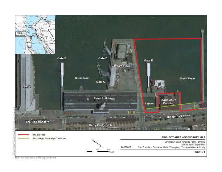
Pier 1 Pier 1 Pier 1 Gate B Gate B Gate C Gate C Gate D Gate D Gate E Gate E Ferry Plaza Ferry Plaza Ferry Plaza Ferry Building Ferry Building Agriculture Agriculture Building Building The Embarcadero The Embarcadero Harry Bridges Plaza Harry Bridges Plaza T h e E m b a r c a d e r

  • T

h e E m b a r c a d e r

  • Gate B

Gate C Gate D Gate E Ferry Building Agriculture Building The Embarcadero Harry Bridges Plaza T h e E m b a r c a d e r

  • North Basin

South Basin Lagoon

Pier 2 Pier 2 Pier 2

100 200 FEET

Source: Roma Design Group, et al, 2010, Google Earth Pro 2013.

28067812 Downtown San Francisco Ferry Terminal South Basin Expansion San Francisco Bay Area Water Emergency Transportation Authority

PROJECT AREA AND VICINITY MAP FIGURE 1

8/5/15 hk...T:\WETA\Permits 2015\July2015\Fig1_project_area_vicinity_map.ai

Project Area Mean High Water/High Tide Line

S a n F r a n c i s c o B a y S a n P a b l o B a y P a c i f i c O c e a n

" )

% & ' (

80

Project Location

A L A M E D A S A N M A T E O M A R I N C O N T R A C O S T A S A N F R A N C I S C O Orinda Pinole Novato Moraga Oakland Vallejo Hayward Alameda Concord Benicia Pacifica Piedmont Richmond Millbrae Brisbane Larkspur Martinez Hercules San Ramon Sausalito Lafayette Union City San Rafael Burlingame Emeryville San Leandro Mill Valley Walnut Creek San Francisco Pleasant Hill

% & ' (

680

% & ' (

580

% & ' (

238

% & ' (

80

% & ' (

880

% & ' (

780

% & ' (

280

% & ' (

980

% & ' (

380

% & ' (

238

% & ' (

580

% & ' (

580

| ÿ

1

| ÿ

92

| ÿ

4

| ÿ

101

| ÿ

112

| ÿ

35

| ÿ

123

| ÿ

13

| ÿ

185

| ÿ

131

| ÿ

84

| ÿ

242

| ÿ

29

| ÿ

84

slide-2
SLIDE 2

THE EMBARCADERO FERRY BUILDING

SOUTH BASIN

EXISTING GATE E TO BE RELOCATED AND EXTENDED GATE F GATE G AGRICULTURE BUILDING FERRY PLAZA THE EMBARCADERO FERRY BUILDING EAST BAYSIDE PROMENADE PIER 14 BREAKWATER INTERIM ACCESS STRUCTURE GATE C GATE D GATE B EMBARCADERO EMBARCADERO PLAZA PLAZA AGRICULTURE BUILDING

Downtown San Francisco Ferry Terminal South Basin Expansion San Francisco Bay Area Water Emergency Transportation Authority 28067812

10/08/15 hk T:\WETA\Permits 2015\BCDC_Sept15\Figs_WETA_BCDC_Sept15.indd Source: Roma Design Group, et al, 2015

FIGURE 2 SOUTH BASIN IMPROVEMENTS PLAN VIEW

FEET

Source: Roma Design Group, et al, 2015

75 150

Existing Elements New Project Improvements Mean High Water/High Tide Line

slide-3
SLIDE 3

S E A W A L L MAINTAIN AND PROTECT MAINTAIN FENDERING GATE E PIER 2 MAINTAIN AND PROTECT

DEMOLISH AND REMOVE

10/8/15 hk...T:\WETA\Permits 2015\BCDC_Sept15\Fig3_demo_repair.ai

50 100 FEET

SOUTH BASIN

Source: Roma Design Group, et al, 2011

Demolish and Remove Maintain and Protect

Notes:

  • 1. The America's Cup project will remove the building

located on Pier 2 prior to project construction.

  • 2. Portions of Pier 2 will be replaced.

28067812 Downtown San Francisco Ferry Terminal South Basin Expansion San Francisco Bay Area Water Emergency Transportation Authority

AREAS PROPOSED FOR DEMOLITON AND REPAIR

FIGURE 3

slide-4
SLIDE 4

EXISTING GATE E TO BE RELOCATED AND EXTENDED ADAPT EXISTING STRUCTURE TO NEW GRADE

NEW BERTHING STRUCTURES

GATE F GATE G NEW FENDERING NEW FENDERING INTERIM ACCESS STRUCTURE NEW DECK AND PILES EAST BAYSIDE PROMENADE EMBARCADERO EMBARCADERO PLAZA PLAZA

Downtown San Francisco Ferry Terminal South Basin Expansion San Francisco Bay Area Water Emergency Transportation Authority 28067812

10/08/15 hk T:\WETA\Permits 2015\BCDC_Sept15\Figs_WETA_BCDC_Sept15.indd Source: Roma Design Group, et al, 2015

FIGURE 4 AREAS PROPOSED FOR IMPROVEMENT

Source: Roma Design Group, et al, 2015

50 100

New Deck and Piles Relocated Float and Gangway New Berthing Structures and Fendering Interim Access Structure Existing Areas to be Adapted to the New Grade

slide-5
SLIDE 5

U.S. Army Corps of Engineers, Department of Army Permit Application • Prepared for the Water Emergency Transportation Authority by ROMA Design Group • July 22, 2015

Gangway Guide Piles Float Entry Portal

Downtown San Francisco Ferry Terminal South Basin Expansion San Francisco Bay Area Water Emergency Transportation Authority 28067812

07/27/15 hk T:\WETA\Permits 2015\July_2015\Figs_WETA_Jul15.indd Source: Roma Design Group, et al, 2015

FIGURE 5 SIMULATED VIEW OF BERTHING FACILITIES

slide-6
SLIDE 6

Downtown San Francisco Ferry Terminal South Basin Expansion San Francisco Bay Area Water Emergency Transportation Authority 28067812

10/08/15 hk T:\WETA\Permits 2015\BCDC_Sept15\Figs_WETA_BCDC_Sept15.indd Source: Roma Design Group, et al, 2015

FIGURE 6 SITE PLAN

Source: Roma Design Group, et al, 2015

slide-7
SLIDE 7

U.S. Army Corps of Engineers, Department of Army Permit Application • Prepared for the Water Emergency Transportation Authority by ROMA Design Group • July 22, 2015 Downtown San Francisco Ferry Terminal South Basin Expansion San Francisco Bay Area Water Emergency Transportation Authority 28067812

07/27/15 hk T:\WETA\Permits 2015\July_2015\Figs_WETA_Jul15.indd Source: Roma Design Group, et al, 2015

FIGURE 7 MODEL VIEW OF EMBARCADERO PLAZA AND PROMENADE

slide-8
SLIDE 8

U.S. Army Corps of Engineers, Department of Army Permit Application • Prepared for the Water Emergency Transportation Authority by ROMA Design Group • July 22, 2015 GATES E, F & G FERRY TERMINAL ENTRANCES EAST BAYSIDE PROMENADE EXTENSION NEW EMBARCADERO PLAZA EXISTING SEAWALL EXISTING EMBARCADERO PROMENADE

Downtown San Francisco Ferry Terminal South Basin Expansion San Francisco Bay Area Water Emergency Transportation Authority 28067812

07/27/15 hk T:\WETA\Permits 2015\July_2015\Figs_WETA_Jul15.indd Source: Roma Design Group, et al, 2015

FIGURE 8 TYPICAL CROSS-SECTION VIEW FROM SAN FRANCISCO BAY TO EMBARCADERO

16 32 FEET

slide-9
SLIDE 9

Seawall

Downtown San Francisco Ferry Terminal South Basin Expansion San Francisco Bay Area Water Emergency Transportation Authority 28067812

09/09/15 hk T:\WETA\Permits 2015\BCDC_Sept15\Figs_WETA_BCDC_Sept15.indd Source: Google Earth Pro., 2015

FIGURE 10 VIEWS OF THE EXISTING PROJECT AREA The Embarcadero View Point

slide-10
SLIDE 10

EDGE OF BART PLATFORM EXISTING 90 L.F. OF PERIMETER ACCESS TO BAY & 50 FT WIDE VIEW CORRIDOR TO BAY & BERTHING ACTIVITIES PORT OF SF SOUTH BAYSIDE PROMENADE (NOT PART OF PROJECT) 220 L.F. OF NEW PERIMETER ACCESS TO BAY & 140 FT WIDE VIEW CORRIDOR TO BAY & BERTHING ACTIVITIES 220 L.F. OF NEW PERIMETER ACCESS TO BAY & 140 FT WIDE VIEW CORRIDOR TO BAY & BERTHING ACTIVITIES 200 L.F. OF NEW PERIMETER ACCESS TO BAY & A 180˚ VISTA TO PIER 14, DOWNCOAST ALONG EMBARCADERO PROMENADE TO RINCON PARK, BOW & ARROW SCULPTURE, BAY BRIDGE & BACK TO CITY SKYLINE 40 FT 140 FT 27 FT 27 FT 140 FT 50 FT 210 FT WINDOW 145 FT 1 1 F T 100 FT X 130 FT

TOTAL PUBLIC ACCESS AREA = 36,000 SF

EMBARCADERO PROMENADE PUBLIC ACCESS 50 YEAR SLR ELEVATION (29,100 SF ) (5,300 SF ) PUBLIC ACCESS TRANSITION AREA INTERIM INFILL AREA AT EXISTING GRADE OF AGRICULTURE BUILDING APRONS (2,500 SF)

PROMENADE PROMENADE PLAZA

PIER 14 AGRICULTURE BUILDING FERRY BUILDING LIMIT OF PROJECT WORK INTERIM ACCESS STRUCTURE (1,600 SF) 40 FT 40 FT

Downtown San Francisco Ferry Terminal South Basin Expansion San Francisco Bay Area Water Emergency Transportation Authority 28067812

10/12/15 hk T:\WETA\Permits 2015\BCDC_Sept15\Figs_WETA_BCDC_Sept15.indd Source: Roma Design Group, et al, 2015

FIGURE 11 PUBLIC ACCESS PLAN

Source: Roma Design Group, et al, 2015

40 80

Perimeter Access View Corridors Public Access (50 year sea level rise elevation) Public Access (transition grade)

slide-11
SLIDE 11

U.S. Army Corps of Engineers, Department of Army Permit Application • Prepared for the Water Emergency Transportation Authority by ROMA Design Group • August 10, 2015

GATE E GATE F GATE G

DREDGE VOLUMES GATE F GATE G TOTAL Area (AC) 0.78 1.64 2.42 Cut Volume (CY) 3,600 9,549 13,149 2’ Overdredge (CY) 2,406 4,924 7,330 Total Cut Volume (CY) 6,006 14,473 20,479

Downtown San Francisco Ferry Terminal South Basin Expansion San Francisco Bay Area Water Emergency Transportation Authority 28067812

09/28/15 hk T:\WETA\Permits 2015\BCDC_Sept15\Figs_WETA_BCDC_Sept15.indd Source: Roma Design Group, et al, 2015

FIGURE 12 AREAS REQUIRING DREDGING DURING CONSTRUCTION

Source: Roma Design Group, et al, 2015

100 200 FEET